From Arthur's Pass township to Arthur's Pass...
Woo-hoo, I have finished study for 2015 so time to do some.....tramping!
I went for a tramp on the first day of the Labour Weekend break, just a day trip as we had plans to watch theWorld Cup All Blacks vs South Africa rugbygame on Sunday morning.
My original plan was for a trip up to Carrol Hut near Otira, but when I arrived at the car park at the base of the track I was meet with the still smouldering wreck of a car that had been set on fire. After reporting it to the Police, I decided that maybe this was not such an awesome place to park my car for 5-6 hours.
 |
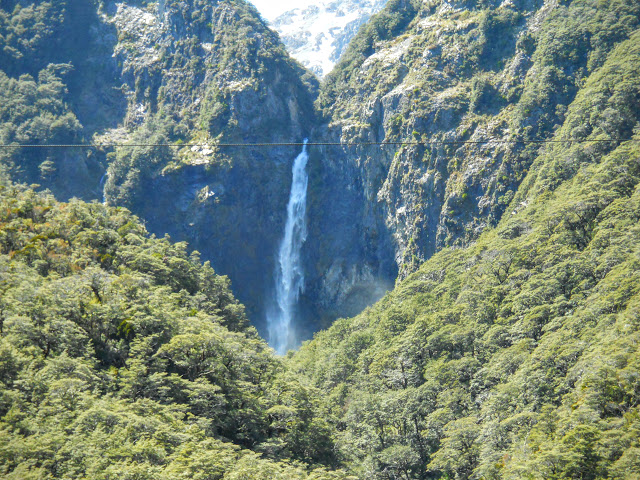
| Punchbowl Falls from the Arthur's Pass Walking Track car park |
Instead I went back to Arthur's Pass and walked the new track from the Devils Punchbowl Falls car park to the pass. I've been wanting to do it for a while and this was the perfect opportunity.
Arthurs Pass Walking Track
The Arthur's Pass Walking Track follows the path taken by Arthur Dobson an early surveyor and the first European to cross the Pass between the Bealey and Otira rivers back in the 1880's.
 |
| Car park at the start of the Arthurs Pass Walking Track |
 |
| Arthurs Pass Walking Track |
There are a series of information panels near the car park laying out the various tracks at this end of the valley. This is the starting point for tracks to Punchbowl Falls, Arthur's Pass, Avalanche Peak, Cons Track and Mt Aicken.
 |
| Arthurs Pass Walking Track: information board at car park |
As you can see nice clear details and the required warning information for tourists, it is a busy spot. Thousands if not tens of thousands of people must walk up to Punchbowl Falls each year while travelling through Arthur's Pass.
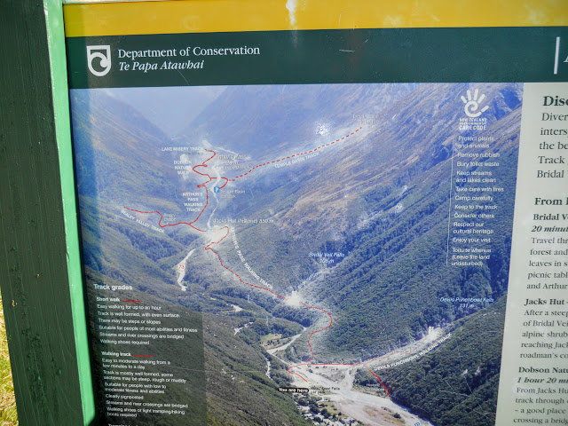 |
| Arthurs Pass Walking Track: details of the board |
The start of the track is very clear, nice signage throughout its length.
 |
| Track junction for Punchbowl Falls and Arthurs Pass Walking Track |
The track quality is excellent, Great Walk standard really, and it stays
at this level all the way to the pass. It certainly makes the track a
lot easier to walk, years ago the previous rough basic track took
about 2.5 hours to the pass, it is now an hour and a half.
 |
| Walkin' Great Walk styles....on the Arthurs Pass Walking Track |
There are plenty of stairs and board walks along the trail here is a shot of the first of many for the day....
 |
| Arthurs Pass Walking Track: First of MANY steps! |
The bush to each side of the track is very dense, Arthur's Pass gets a lot of rain, over 2 meters most years and it actually holds the NZ record for the highest amount of rain in a 24 hour period (it was 2.4 meters, that's 39 inches or 7.8 feet) back in the 1960's.
 |
| Dense bush to side of Arthur's Pass Walking Track |
There are a series of well constructed bridges along the track, they remind me a lot of the ones I've encountered on the Wharfedale and St James tracks. Standard DOC bridge design? Bridge, pedestrians, Mark I.....
 |
| Arthur's Pass Walking Track: example of the bridges en route |
 |
| Jon on one of the bridges, Arthurs Pass Walking Track |
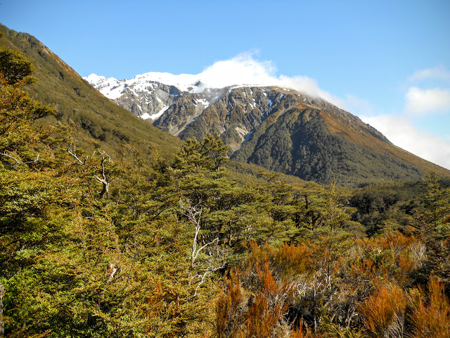
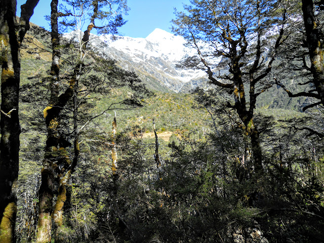
Periodically the far southern side of the valley becomes visible, nice views of Mt Avalanche, Mt Bealey and Mt Rolleston as you climb towards the pass.
 |
| Mt Rolleston and Mt Bealey from Arthurs Pass Walking Track |
 |
| Waterfall on the south side of the Bealey Valley |
The photo below shows the flank of Mt Avalanche as well as the distant and tiny looking buildings of Arthurs Pass township far below. This is a view from a scenic lookout about 30 minutes up the trail, it has a seat and picnic table.
 |
| Flanks of Mt Avalanche from Arthur's Pass Walking Track |
You pass many small side streams on this track, all of them are bridged making this is an all weather track.
 |
| Arthur's Pass Walking Track: nice looking side stream |
I passed a number of Dracophyllum traversii on the way, these are sometimes called "Dr Seuss" trees as they look exactly like the ones in The Lorax. We really have some weird and wonderful plants in New Zealand.
 |
| Dracophyllum traversii tree near Arthur's Pass |
The track follows the route of a high tension power line for most of the way up the valley. The last time I walked this track back in the early 90's it was a rocky and wet experience as no formal track existed. The track was the cut back route of the power line. You still pass under the pylons every now and then on the new track.
 |
| Track passing under the power pylons |
At one point you need to descend and then ascend a series of steps to get around a small gorge, the track has been well routed using a couple of handy gully's either side of the stream crossing.
 |
| Arthurs Pass Walking Track : a stairway to heaven.....? |
 |
| "Goblin" forest on the Arthurs Pass Walking Track |
 |
| View north west towards Mt Rolleston, Bealey Valley |
Eventually you reach Jacks Hut, former home of a well known road man of the early 1900's. Up till the 1980's it was a private bach or holiday home. It must have been some experience living here full time over the winter as the road sometimes gets up to 3 meters of snow in a big storm. Cool!
 |
| Historic Jacks Hut, SH 73 near Arthurs Pass |
Near Jacks Hut the track crosses State Highway SH73, to the south side of the valley and continues up to the Pass. Take care crossing the road as it is very busy and has blind corners in both directions.
 |
| Arthurs Pass Walking Track: there be the track......! |
 |
| Arthurs Pass Walking Track, approaching the tarns on the pass |
 |
| Mt Rolleston and Bealey Valley from the Arthurs Pass Walking Track |
You eventually breakout of the bush after 15minutes past Jacks Hut, the rest of the track is on board walk over a series of classic alpine bog's. There are stunning views in all directions.
 |
| Start of the alpine bog-lands looking down valley, Arthur's Pass |
 |
| Arthurs Pass Walking Track : alpine bog-lands looking up valley |
 |
| Arthurs Pass - Highway 73 looking east or down valley |
There are a series of excellent interpretive panels along the track explaining the flora and fauna, history and topography of the surrounding area.
 |
| Interpretive panel- Alpine plants near Arthurs Pass Tarns |
 |
| No name falls near Temple Basin ski field from the Arthurs Pass Walking Track |
During the last ice age this valley was home to a massive glacier that was 200 meters higher than the existing pass. It stretched all the way to the Canterbury Plains and as far west as Lake Kaniere. That is nearly 100 km's!!!
The whole of Arthur's Pass National Park has been shaped by ice, wind and water.
 |
| Glacial moraine field near Arthurs Pass |
As you can see I have my fleece on, even with the sun it was cold due to the wind from the Otira Valley. I could see steam from my breath as I was walking, too windy for a hat so I got a bit wind burnt on the face.
 |
| Jon standing on Arthur's Pass |
Below is a selection of photos taken as I walked around the short nature walk at the Pass. If you are ever heading for the West Coast stop and have a look, it is fascinating and very beautiful in a stark, rugged kind of way.
 |
| Series of tarns on Arthurs Pass |
 |
| Looking East towards Otira Valley |
Below is a classic kiwi tramping track leading off from the nature walk, this heads to the Otira Valley. This is more like the mess of rock, mud and roots we have come to expect and love on a DOC track.
 |
| A more basic DOC track heading to Otira Valley |
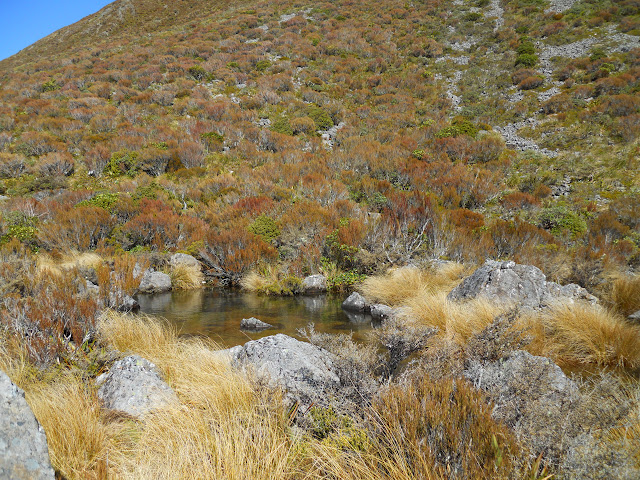 |
| One of the small tarns on Arthurs Pass |
The Arthur Dobson Memorial marks the crest of Arthur's Pass. On the east side is Canterbury, on the west side it is the West Coast. You have just crossed the Southern Alps!
 |
| Arthur Dobson Memorial from the Arthurs Pass Walking Track |
 |
| Arthurs Pass: one of the interpretive panels- glacial action |
 |
| View west towards the West Coast from Arthur's Pass tarns |
 |
| One of the many bridges on the Arthurs Pass Walking Track |
 |
| View towards Mt Bealey from alpine bog lands |
After 20 minutes walking around the nature walk at the tarns I headed back down towards the village.
Below is a view of Jacks Hut from the opposite (southern) side of SH73. There are tracks from this point to the "Chasm" (a point where the Bealey River goes underground) and the Bealey Valley Track both of which are worth a look.
 |
| Jacks Hut from far side of SH73, Arthur's Pass |
 |
| Arthurs Pass Walking Track : one of the picturesque side streams |
I stopped about half way back to the village and sat on a log for a break for 5 minutes listening to the forest, river gurgle and birdsong.
 |
| Stopped for a snack on the Arthurs Pass Walking Track |
 |
| Arthurs Pass Walking Track : new stairs to climb and descend a gully |
 |
| Young Dracophyllum traversii alpine tree |
The scene below will be familiar to anyone who has visited Arthur's Pass, these are the Punchbowl Falls close to the village. They are 112 metres high and come from an ice field on the saddle between Mt Cassidy and Mt Aicken.
I am told that DOC have up graded the track to the falls and they now a wonder of board walk and platforms, I will have to visit sometime to confirm this.
 |
| Punchbowl Falls from near the Arthur's Pass Walking Track car park |
 |
| Close-up of Punchbowl Falls from the car park |
 |
| View up Bealey Valley towards Arthurs Pass |
It was a good days tramping and while not the trip I had planned it still worked out very nicely. It was excellent weather for a walk, dry but not too hot. Even though this is a popular track I only saw four other people on the track. It was surprising but Spring has only just started so possibly there aren't many tourists around yet.
Access: The track starts at the car park for the Punchbowl Falls, this is at the western end of Arthur's Pass township, look for the sign on the Bealey River side of SH73.
Track times: 1.5-2 hours to Arthur's Pass, same return.
Miscellaneous: All weather track, all streams bridged. Take water as all side streams along this track are contaminated. Watch for traffic on SH73 as you cross at Jacks Hut.


No comments:
Post a Comment