A visit to Travis Wetlands following the Christchurch 360 Trail
Over the weekend I completed another short section of the Christchurch 360 Trail. As I've previously said the Christchurch 360 is a series of urban trails that encircle Christchurch. It is approximately 130 km in length and encompasses urban tracks as well as the Port Hills, the beach and Waimakiriri River banks.
The section I walked on Saturday was from Burwood Road, through Travis Wetlands and then down to Waimairi Beach skirting Bottle Lake Forest Park.
 |
| The Port Hills from Travis Wetlands, near Marahau Road |
Bower Avenue to Travis Wetland entrance, Travis Road
This section is approximately 6 km's long, about two fairly easy walking hours in total. Because the ends of the section are so far apart it makes sense to use the local bus services to get yourself down to the Travis Road entrance to Travis Wetlands.
 |
| Map: Travis Wetlands to Bottle Lake Forest. Circles denote other entrances to wetlands |
The start of this section is at Travis Wetlands so I jumped on the Orange Line bus at Bower Ave park and rode it to the intersection of Burwood Road and Travis Road. It is a short 5-10 minute walk east along Travis Road to get to the entrance to Travis Wetlands.
 |
| Orange line bus waiting at the Bower Avenue Park stop |
 |
| Waking up Burwood Road to the entrance to Travis Wetlands, Christchurch 360 Trail |
I jumped off the bus early so I could walk past Newhaven Street. This is the first street I lived in when we came to New Zealand from the US back in 1974. The original house is long gone, destroyed by the 2010 Earthquake (like so many others on this eastern side of Christchurch).
 |
| The first street I lived in when I came to New Zealand |
 |
| Passing Waitakiri School on the way to Travis Wetlands...my first primary school |
At the end of Burwood Road you take a left turn and walk down Travis Road for about a kilometre to the entrance to Travis Wetlands.
 |
| Start of Travis Road heading to the Travis Wetlands entrance |
 |
| Jon walking down Travis Road to the start of the track |
To those non Kiwis amongst you, we have a national election being held in the last week of September so we are being bombarded with election hoardings from the various parties. I don't know why they bother really as 90% of people will have decided who they are voting for long before they are allowed to erect the signs.
 |
| Election hoardings along Travis Road |
Into Travis Wetlands
The first part of the trail is through
Travis Wetlands, a regenerating Raupo/Kahikatea swamp on the eastern boundary of the city. There was a historic swamp forest in this area which was cut down in the mid 1880's to build houses in the Christchurch CBD.
 |
| Map: Travis Wetlands tracks and access points |
I decided to enter Travis Wetlands from the Travis Road entrance to the area. This is not the official Christchurch 360 track entrance but in fact gives a much nicer introduction to this wetland park.
 |
| Travis Wetlands entrance on Travis Road |
 |
| Travis wetlands: I didn't see any machinery...must be working during the week |
 |
| A small mire or swamp lake in Travis Wetlands, Christchurch 360 Trail |
 |
| Private properties adjoining Travis Wetlands, Christchurch 360 Trail |
 |
| Nice pebble track, Travis Wetlands, Christchurch 360 Trail |
Travis Wetlands is a nature reserve and an area of native swamp regeneration. Christchurch originally consisted of a series of Raupo/Kahikatea swamps that reached from just behind the beach all the way to Riccarton Bush about 12 km's inland. As the city was built up the land was drained and used for residential housing and farms.
Back in the late 1980's this old farmland was retired and a concerted effort made to return it to the type of swamp it would have been prior to European settlement. This is a long term programme which will take 50 odd years to complete.
 |
| A view out over Travis Wetlands, Christchurch 360 Trail |
 |
| One of the public parks incorporated into Travis Wetlands |
 |
| Alternate entry point to Travis Wetlands, Christchurch 360 Trail |
 |
| Native cabbage trees, flaxes and Miro trees, Travis Wetlands |
As you can see the
City Council and the
Travis Wetlands trust charged with this regeneration have been planting native trees in the area. Eventually this will constitute a three tier Kahikatea Forest with trees ranging from 30 metres high to swamp tussocks and sedges. As a mature Kahikatea tree needs 300-400 years to grow this process is only just starting.
 |
| Fence to stop animals entering the wetlands, Travis Wetlands, Christchurch 360 Trail |
The old willows that once clothed this swamp are slowly being removed as native trees mature enough to cope without their protective presence. Eventually this will be an all native swamp forest.
 |
| Old Willow trees being removed from Travis Wetlands, Christchurch 360 Trail |
 |
| The viewing platform which overlooks Travis Wetlands, Christchurch 360 Trail |
 |
| View from the top of the tower towards the Beach Road entrance point, Travis Wetlands |
It is difficult to see but there are a multitude of Kahikatea trees growing out on this old pasture land. Kahikatea are a type of swamp pine...they like wet, sandy soil with regular inundation and will thrive in this area.
 |
| Old pasture gradually regenerating into swamp, Travis Wetlands, Christchurch 360 Trail |
 |
| The effect they are trying to create...Kahikatea Swamp near Franz Josef, Westland |
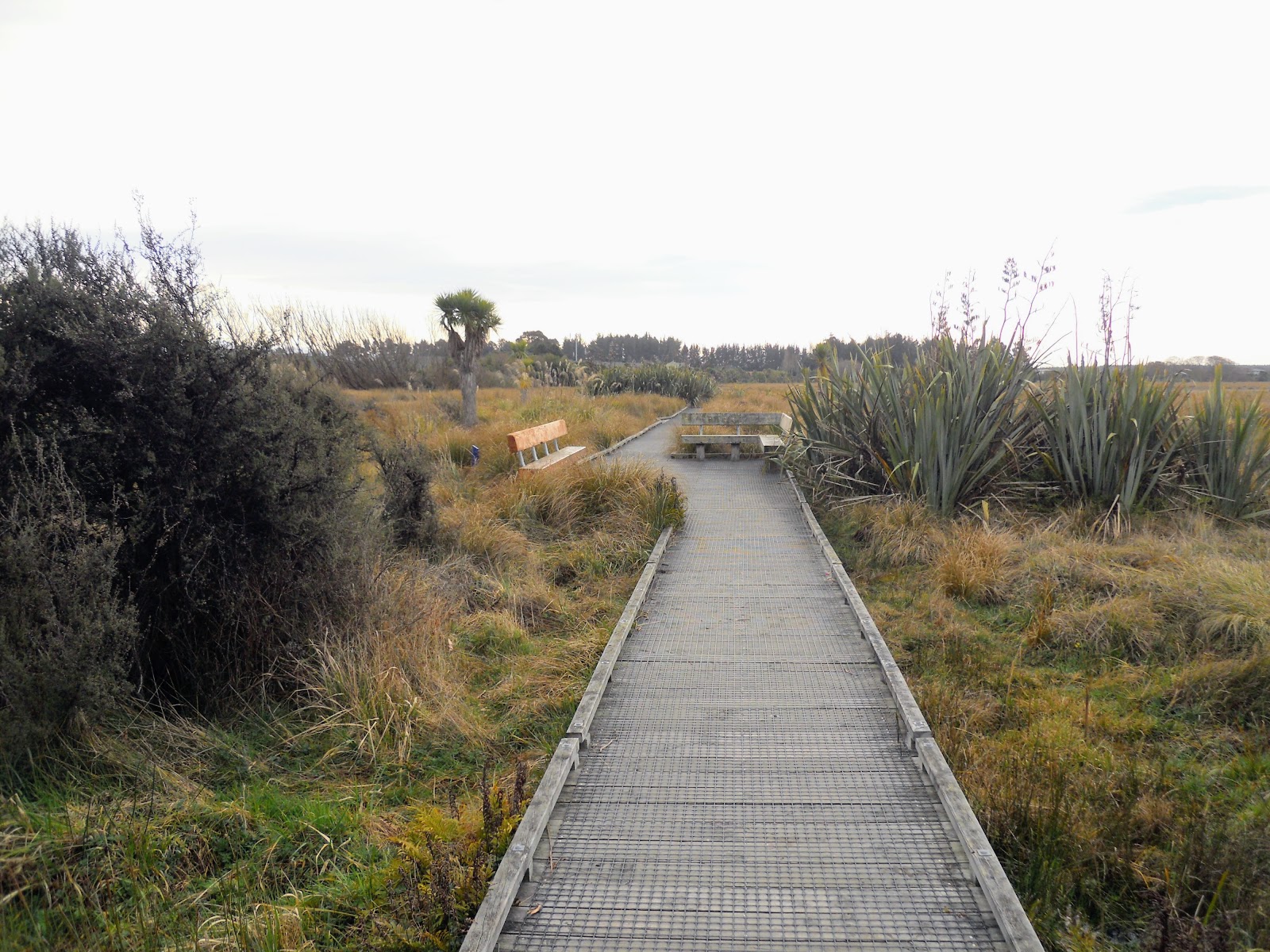
 |
| Nice board walks above Travis Wetlands, Christchurch 360 Trail |
As well as the forest there are a lot of small lakes and ponds for waterfowl to use. At present there are Pukeko, Swans, Herons, Cormorrants, Mallard Ducks and Geese living in the reserve. Once the forest grows there will also be Fantails, Wood Pigeons, Bellbird and Tui as all these types of birds live in Kahikatea forest.
 |
| Beach Road entrance and Information Centre in the distance, Travis Wetlands, Christchurch 360 Trail |
 |
| More of the board walks in Travis Wetlands, Christchurch 360 Trail |
Below is a juvenile Kahikatea tree, these are about five years old which shows you how slowly they grow. If it survives this tree will eventually be 2-4 metres around the trunk and 30-40 metres high or 100-140 feet tall!
 |
| What it is all about...a Kahaketea Tree, Travis Wetlands, Christchurch 360 Trail |
 |
| Close up of juvenile Kahaketea Tree |
There are wide expansive vistas over the Wetlands, eventually these will be constricted as the tree planting progresses further into the swamp. There are a number of connecting tracks through the swamp- more are planned but as this is a volunteer effort progress is slow.
 |
| Travis Wetlands, Christchurch 360 Trail...the beach is about 5 kms in that direction! |
 |
| Jon on trail in the centre of Travis Wetlands, Christchurch 360 Trail |
As you can see from this photo, the Port Hills dominate the Christchurch skyline...you can see them from as far as 60 kilometres inland. I know I'm home when I see that oh so familiar sight...
 |
| The Port Hills from the Travis Wetlands, Christchurch 360 Trail |
 |
| Exit onto Marahau Road, Travis Wetlands |
 |
| Native Pukeko dwelling in Travis Wetlands, Christchurch 360 Trail |
 |
| Pukeko from behind... |
 |
| ...and Pukeko from the front! |
I would never do so, but you can hunt Pukeko at certain times of the year. It is around the same time as duck hunting season. How do they taste? There is a well known recipe that goes in part...
"...catch your Pukeko, place this along with an old leather boot in a large pot of boiling water. Cook for 6-8 hours, remove Pukeko and eat boot..."
 |
| The Information Centre is right next to the trees centre left, Travis Wetlands, Christchurch 360 Trail |
 |
| Travis Wetland information board |
 |
| The Christchurch 360 trail continues alongside Marahau road |
 |
| Example of the grass-wetland margin at Travis Wetlands |
 |
| Another Pukeko at Travis Wetlands, Christchurch 360 Trail |
 |
| Old willows protecting Kahikatea, Cabbage Trees, flaxes and sedges in Travis Wetlands, Christchurch 360 Trail |
f
 |
| View back towards the Travis Road entrance to Travis Wetlands, Christchurch 360 Trail |
 |
| Travis Wetlands car park on Marahau Road |
 |
| Near the end of the Travis Wetlands section of the Christchurch 360 |
At the end of this pathway you cross Marahau Road and start the walk up Putake Drive, Parklands.
Other access points to Travis Wetlands
There are entry points to Travis Wetlands on Travis Road, Beach Road and in two separate places along Marahau Road.
 |
| Marahau road entrance to Travis Wetlands |
 |
| Nice appropriate planting around the car parks at Travis Wetlands |
Through Parklands to Bottle Lake Forest
The next part of the section is a walk up Putake Drive to the edge of Bottle Lake Forest Park. Once at Bottle Lake Forest the trail skirts the edge of the trees for about 2.5 kilometres to Bower Avenue Park near Waimairi Beach. This is both road walking and forest trails.
 |
| Waking along Marahau road to Putake Drive and Bottle Lake Forest |
 |
| Turn right into Putake Drive for the Christchurch 360 Trail |
 |
| Putake Drive, Parklands, on the Christchurch 360 Trail |
There is not a lot of trail marking along this section, you see the odd Christchurch 360 symbol on the track maps and the occasional marker like the one below. This is on one of the lamp posts along Putake Drive.
 |
| Christchurch 360 trail maker on Putake Drive |
 |
| Nice planting along the pathway, Putake Drive, Christchurch 360 Trail |
 |
| Approaching Bottle Lake Forest, Christchurch 360 Trail |
When you get to the end of Putake Drive you turn right and head along the walking/MTB track running along close to the houses. Just keep heading to the east and eventually you will reach the beach and Bower Avenue Park.
 |
| Christchurch 360 marker at end of Putake Drive... |
 |
| ...and from the other side looking back along Putake Drive |
 |
| Close up of the Christchurch 360 logo...arrows denote change of direction. |
 |
| Christchurch 360 Trail, the pathway skirting Bottle Lake Forest |
Along the edge of Bottle Lake Forest
The land
Bottle Lake Forest sits on is owned by the City of Christchurch. Unfortunately the trees belong to Matiriki, a Nga Tahui owned forestry company. The forest is in the process of being harvested which is a god-damn shame because it is a magnificent recreational resource...but who ever let that stand in the way of making some cold hard cash...sorry, I digress.
 |
| Bottle Lake Forest sign, Christchurch 360 Trail |
 |
| Turn left to follow the Christchurch 360 Trail |
 |
| Timber felling under-way in Bottle Lake Forest |
We are not able to access the actual course of the Christchurch 360 trail while the timber felling is under-way. As you can see in the photo below the official track goes north past this block of forest and then follows 23rd Ave all the way out to the beach at Waimairi.
 |
| The Christchurch 360 Trail track goes that way...we cannot! |
All of these forestry roads have military names: they are either named after WWII infantry battalions (18th/22nd/21st...all Canterbury units) or letters of the phonetic alphabet (Victor/Uniform/Juliet). At the end of WWII/Korean War most of the NZFS forest rangers who managed this forest were ex-servicemen. The rangers worked in the forest right up till the changes to the NZFS in the early 1980's.
One of my uncles who served in the Korean War worked here for nearly 30 years.
 |
| Christchurch 360 Trail, keep skirting the Bottle Lake Forest all the way to the beach |
 |
| Christchurch 360 Trail, easy to follow road along Bottle Lake forest |
This empty swathe between the forest and houses is a fire break, it used to be about 20 meters wide but after several fires they made it 40-100 meters wide.
 |
| The suburb of Parklands as seen from the Christchurch 360 Trail near Bottle Lake forest |
 |
| Better to just follow the walkway to the beach and not the Christchurch 360 Trail |
 |
| Last part of Bottle Lake Forest before the end of the section at Bower Ave park |
 |
| The beach is 10 minutes walk that direction... |
The actual Christchurch 360 trail follows 22nd/23rd/29th Avenues through the forest, it crosses the road shown below about a kilometre north of this point. This then joins onto the Southern Pegasus Walkway which continues out to Brooklands.
 |
| The actual Christchurch 360 Trail route is down there somewhere...near Bower Ave park |
I parked my car on the far side of Bower Ave park, there is a bus stop on the corner of Bower Avenue and Parklands Drive which can take you to Travis Road. Please note: they play club rugby at this park on Saturday morning...there is little to no parking from about 8am to 11am most Saturdays.
 |
| Bower Avenue, Parklands...end of this section of the Christchurch 360 Trail |
 |
| Bower Ave park and the toilet block there... |
 |
| The Port Hills from Bower Ave park..Mt Herbert just visible in centre of photo |
Too be quite frank, I would just follow the
gravel pathway all the way from Putake Drive to Bower Park, at least until they finish harvesting the forest. It is easier to walk on and takes you to almost exactly the same place without the need to dodge exclusion zones.
 |
| Bottle Lake Forest Park sign/map |
The map below is wrong...there is actually a road between 23rd Ave and 29th Ave so you don't have to go bush bashing.
The exclusion zones on these maps are where the earthquake debris from the Christchurch CBD are partially buried. When they are finished in 2020 or so there will be two massive hills about 200 metres high and 2 kilometres long. They plan to cover them with soil and plant trees on them.
 |
| Bottle Lake Forest, Christchurch 360 Trail..the actual 23rd-29th Ave connector track! |
 |
| Close up of the Bottle Lake Forest Park sign/map |
 |
| Orange Line bus waiting for custom...Bower Ave Park...that is Mt Herbert in the middle far distance |
 |
| Bower Ave Park: Orange Line bus and start/end point of trip |
 |
| Orange Line bus stop at Bower Ave park. 'Silver surfer' parked in the background to right |
One more section knocked off the Christchurch 360 trail, I'm slowly getting closer to the finish line, then I'll need to think of something else to do for weekend fitness walks.
Access: Multiple access points to Travis Wetlands. This trip involved a bus ride from Bower Ave to Burwood Road, I walked up to and through Travis Wetland, along Putake Drive to Bottle Lake Forest. From there follow the trail east to Bower Ave park and Waimairi Beach.
Track Times: From Burwood Road to Bower Avenue park is about 2 hours walk, or approximately 6 kilometers.
Miscellaneous: No toilets and no potable water along this track section. Be careful around traffic as you cross several busy roads. The track is a all weather route.