Day walking in Arthur's Pass, part two...
After finishing the Bealey Valley Track, I jumped into the car and drove down to the Devils Punchbowl Falls on the western edge of Arthur's Pass Village. The Falls are the third highest in Arthur's Pass National Park and are particularly impressive if it has been raining in the last 2-3 days.
 |
| The Devils Punchbowl Falls, Arthur's Pass from the track |
This track is probably one of the most visited sites in the country as it is a short and not overly difficult track to a really gorgeous 112 meter waterfall. It features in Lonely Planet so a lot of international visitors stop here on their way over Arthur's Pass.
On the Devils Punchbowl Falls Track, 1 hour return
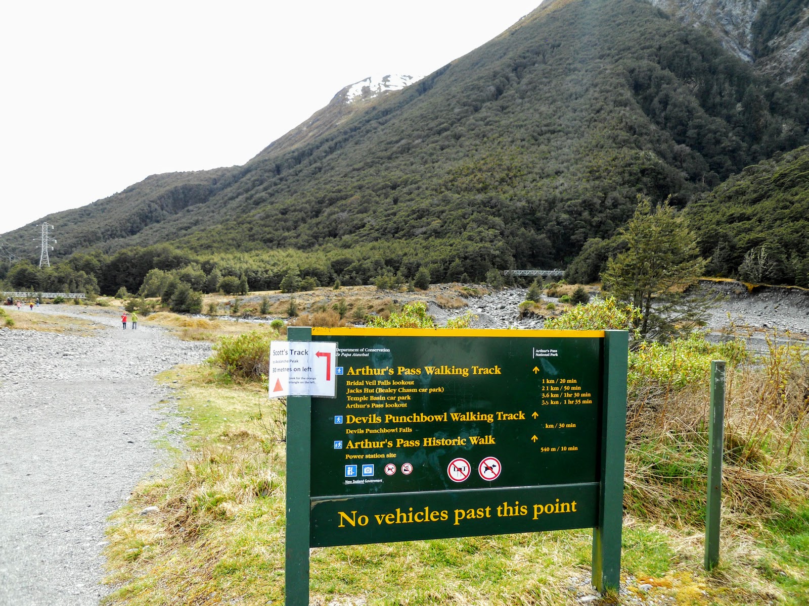
You can walk to the start of this track from anywhere in Arthur's Pass Village but there is a large car-park situated right near the start of the track. It sits right out on the western edge of Arthur's Pass, and is the last gravel roadway on the right as you drive towards the Pass.
 |
| Entrance to car park for The Devils Punchbowl Falls, Arthur's Pass and Arthur's Pass Walking Track |
 |
| Map: Track network around Arthur's Pass village |
 |
| DOC sign at end of Arthur's Pass Village |
The car-park will hold about 30-40 cars, it was 12 noon when I got here so it was totally full. The car park is the starting point for a number of tracks:
Cons Track to the top of Mt Cassidy
Scott's Track to the summit of Avalanche Peak
Mt Aicken Track
Devils Punchbowl Falls Track
Arthur's Pass Historic Walk
Arthur's Pass Walking Track
 |
| Track sign at the Devils Punchbowl Falls, Arthur's Pass car park |
 |
| Start of The Devils Punchbowl Falls, Arthur's Pass and Arthur's Pass Walking Track |
You can see the Falls and the bridge over Devils Punchbowl Falls Creek from the car-park, you can also see Mt Cassidy in the photo below, the object of a future tramp in the park...
 |
| Mt Cassidy from near the start of Devils Punchbowl Falls and Arthur's Pass Walking Track |
There is an interesting stone hut just before you reach the bridge over the Bealey River, I think it belongs to the New Zealand Alpine Club (NZAC)..there are a number of similar huts in the village belonging to various schools, tramping clubs, alpine clubs and private individuals.
 |
| An interesting stone house, next to the Arthur's Pass Walking Track |
The bridge across the Bealey river was built in the 1970's prior to that there was a swing bridge across the river. This solid bridge has been here since I was a child, I must have walked over it 40 odd times over the years while visiting the National Park. There is a nice interpretative panel on the far side of the bridge...
 |
| Bridge over the Bealey River, Arthur's Pass Village |
 |
| The Devils Punchbowl Falls, Arthur's Pass |
Once on the true left of the Bealey you just follow the nice track up to the second bridge over Devils Punchbowl Falls Creek. At the track junction you can go two ways...right is the Arthur's Pass Walking Track and right is the Devils Punchbowl Falls Track.
The side track to Mt Cassidy, Cons Track starts about 20 meters away from the Devils Punchbowl Falls Creek bridge. Con was the name of one of the legendary NZFS park rangers who worked in the area in the 1960-1980's.
 |
| Track Junction: left for the track to Otira, right to The Devils Punchbowl Falls |
 |
| Arthur's Pass Village from the Devils Punchbowl Falls Track, Arthur's Pass |
 |
| The bridge over the Devils Punchbowl Creek |
 |
| The Bridge over Devils Punchbowl Creek |
 |
| the Devils Punchbowl Falls Track, Arthur's Pass at the head of the creek |
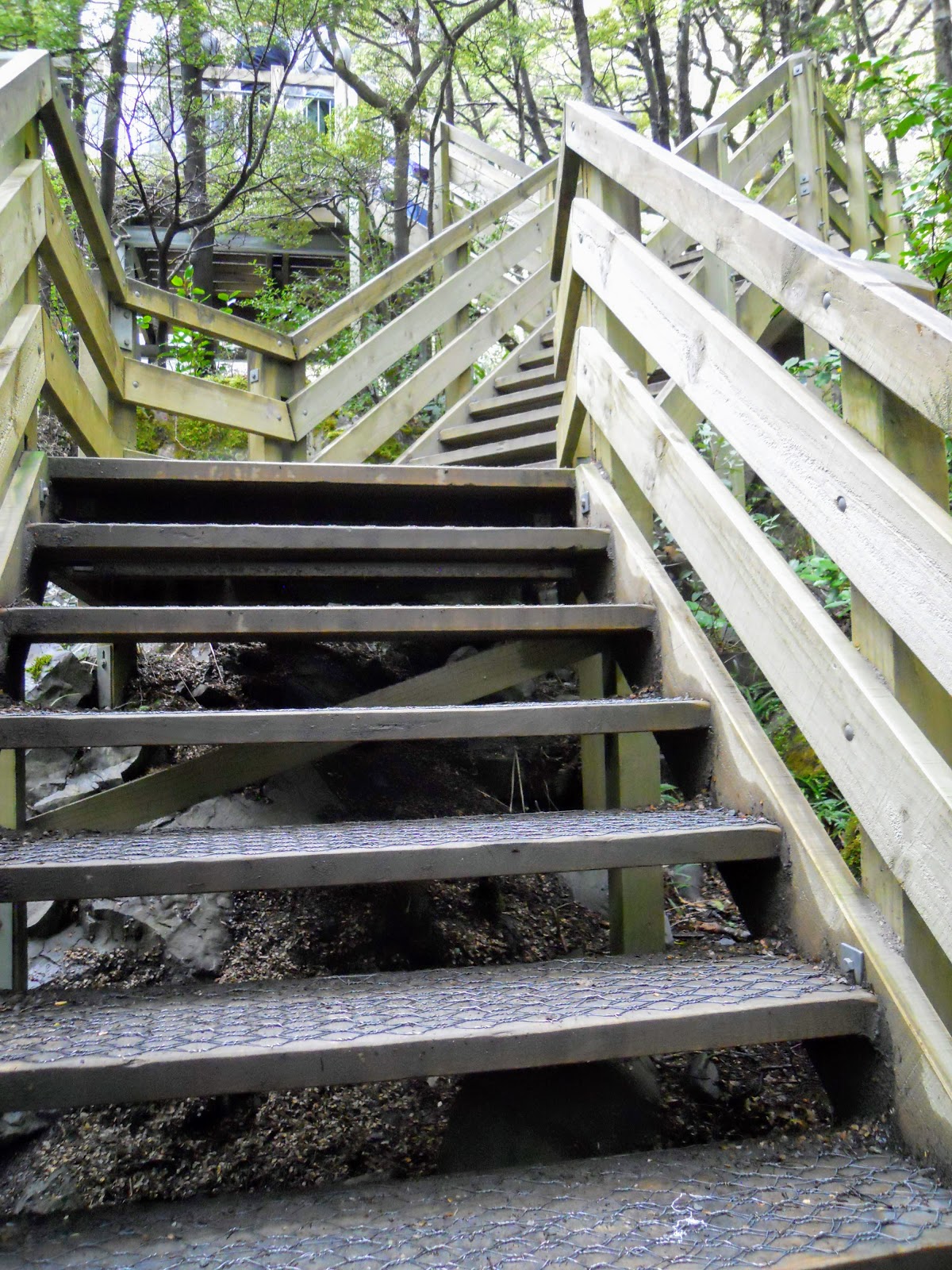
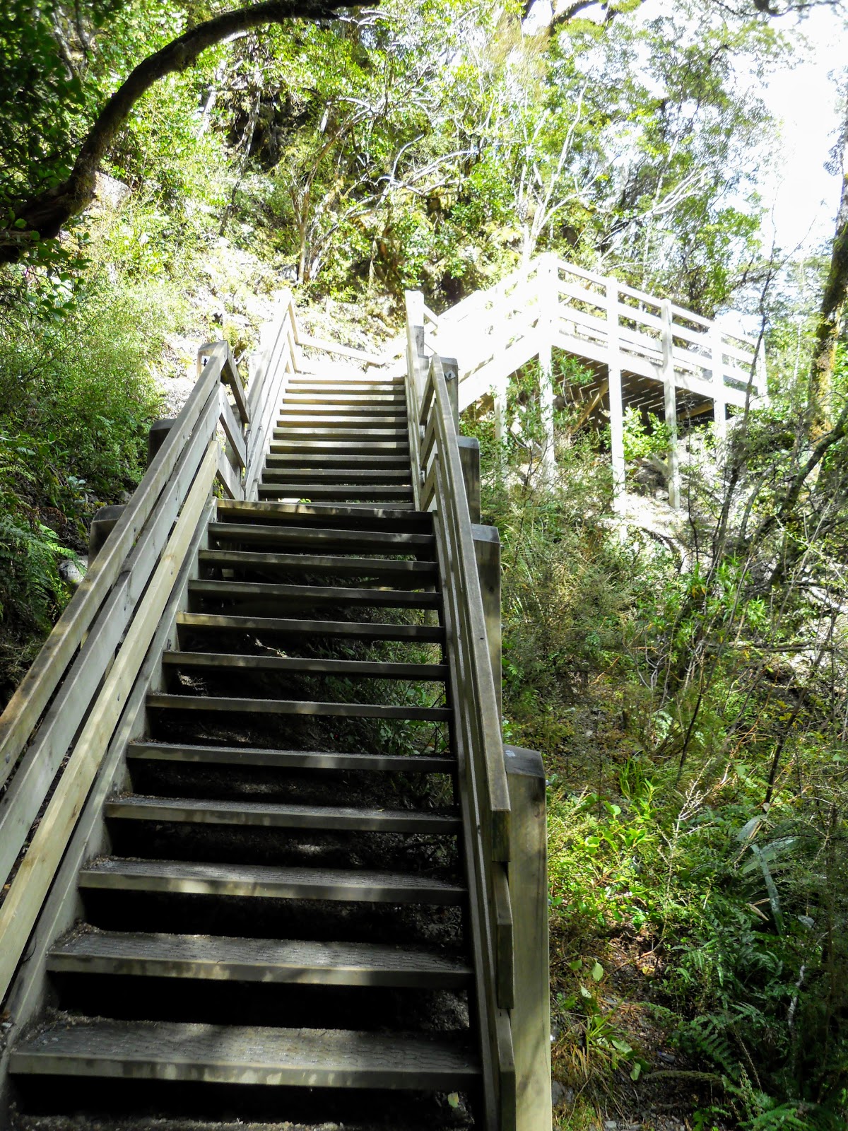
Once over the second bridge the Devils Punchbowl Falls Track starts proper, it is flat at first then turns into a long series of stairways which take you up the side of Mt Aicken.
Once you get to about 100 meters it sidles along the side on Mt Aicken and into the valley holding Devils Punchbowl Falls Creek.
 |
| Start of the the Devils Punchbowl Falls Track, Arthur's Pass |
 |
| Turn off for the Arthur's Pass Historic Track |
Here is the first of many, many staircases you will climb on this track...
 |
| Lots of stairs on the Devils Punchbowl Falls Track, Arthur's Pass |
 |
| the Devils Punchbowl Falls Track, Arthur's Pass....even more stairs |
 |
| View West from the Devils Punchbowl Falls Track, Arthur's Pass |
Up until the mid 2000's this was a very basic dirt track running up and along the side of Mt Aicken, but once mass tourism hit New Zealand DOC built this new track to control erosion and increase visitor safety margins.
On the old track there were two hairy arsed spots where you could fall 30-50 meters off the side of the hill, not ideal terrain for your average middle aged foreign tourist!!!
 |
| Even more stairs on the Devils Punchbowl Falls Track, Arthur's Pass |
 |
| Close up of the stair structure: the Devils Punchbowl Falls Track, Arthur's Pass |
Once you reach the apex of the track you lose all that altitude gain as the track descends right down to the creek bed. On the old track you stayed on the side of Mt Aicken right to edge of the Falls, back then you could look down into the cauldron where the falls land.
The old track had a better view but it was way, way more dangerous...
 |
| Descending down to the Falls, the Devils Punchbowl Falls Track, Arthur's Pass |
 |
| The track sidles along the flank of Mt Aicken: the Devils Punchbowl Falls Track |
 |
| An attempt at a track border, the Devils Punchbowl Falls Track, Arthur's Pass |
 |
| A beautifully formed track...the Devils Punchbowl Falls Track |
 |
| Descending to the viewing platform, the Devils Punchbowl Falls Track, Arthur's Pass |
Once down in the creek bed you climb up onto a new platform which gives you a very nice view of the falls. It was quite busy on the day I was there so I had to wait for about 10 minutes so I could get some shots of the falls without a crowd in front of me.
 |
| Climbing to the viewing platform, the Devils Punchbowl Falls Track |
 |
| Climbing to the viewing platform, the Devils Punchbowl Falls Track |
 |
| Climbing to the viewing platform, the Devils Punchbowl Falls Track |
The Devils Punchbowl Falls flow right throughout the year but they are most impressive if you come up here when it has been raining for a couple of days. Then they are a ferocious, thundering monster with dense clouds of mist flowing down the creek bed.
This is an all weather track but obviously don't come up here if the Bealey River is lapping around the bridge as it is wont to do on occasion. Arthur's Pass gets 8 meters of rain a year (twice as much as Fiordland), the river valleys are narrow, the rivers flood...you get the idea!!!
 |
| The Devils Punchbowl Falls (112 meters) |
 |
| Interpretive panel at The Devils Punchbowl Falls |
 |
| The Devils Punchbowl Falls |
 |
| View down the creek from the platform for the The Devils Punchbowl Falls |
 |
| The Devils Punchbowl Falls |
After sitting for awhile and taking a few photos I headed back down the track to the car-park. It takes about 30 minutes to get to the falls from the car park and about 25 to get back so give yourself 1-1.5 hours to walk the Devils Punchbowl Falls Track and enjoy the scenery.
 |
| On the way back to the car-park, The Devils Punchbowl Falls Track |
 |
| Climbing up to the apex of the The Devils Punchbowl Falls Track |
The trip out is the exact opposite of the trip in....just follow the same track back to the car park.
 |
| Almost at the apex.....The Devils Punchbowl Falls Track |
Just past the high point on the Devils Punchbowl Falls Track there is a side track to the top of Mt Aicken. This is a very steep, exposed track which takes about 3 hours to get to a point directly opposite Avalanche Peak.
I plan to come back and walk this track some time in the near future, if you decide to head up there make sure you are fully prepared for alpine conditions and do not go up the track in the avalanche season as it can be very dangerous.
 |
| The rough and ready track to Mt Aicken, from the The Devils Punchbowl Falls Track |
 |
| Climbing back down the stairs...The Devils Punchbowl Falls Track |
 |
| Heavy forest around the head of the Devils Punchbowl Falls Creek |
 |
| The bridge over Devils Punchbowl Creek from the Devils Punchbowl Falls Track |
I turned off the track and went along the Arthur's Pass Historic Track for a change of scene, I will be writing a post about this some time in the near future. Suffice it to say just walk back over the Bealey River bridge or if the river is low and you are keen why not try an easy crossing of the Bealey River.
 |
| Last view of The Devils Punchbowl Falls, true right of the Bealey |
So another fine day walk in Arthur's Pass, I thoroughly recommend it to anyone passing over the pass, take the time to stop and enjoy some fine alpine scenery if you are ever in the vicinity.
Access: Turn
off SH 73 gravel road, right hand side, on the western edge of Arthur's Pass township. The
track starts next to the car-park. The first 500 meters are on the
Arthur's Pass Walking Track, then turn off to the Devils Punchbowl Falls Track
Track times: 1-1.5 hours return if time is spent admiring the falls from the viewing platform
Miscellaneous: Do not leave the track or attempt to approach the Punchbowl Falls as the area is prone to rock fall and is wet and slippery at all times. No toilets at
any point along this track.Do not drink the water out of Punchbowl Falls Creek as it has Giardia in it from time to time.