...more St James Walkway adventures...
Continuing on from the start of my tramp on the St James Walkway lets look at day four of my trip. At the end of the previous post I was having a pit day at Christopher Hut due to bad weather.
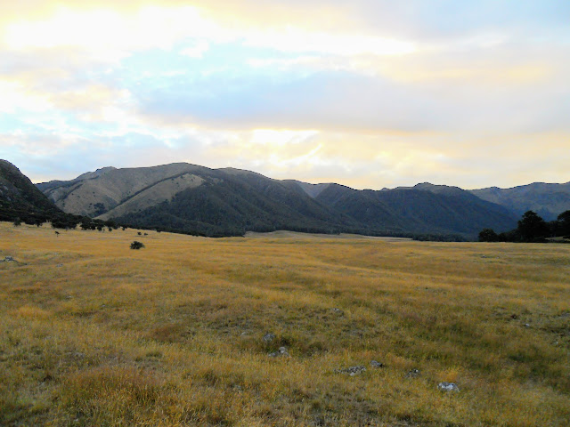
 |
| On the approach to Anne Hut on Day four |
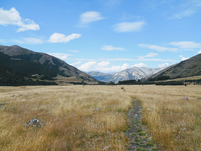
On day four I set out from Christopher Hut on the 4-5 hour trip to Anne Hut further along the walkway. It is by far the easiest day of the track as you are walking across flat grassy plains for most of the way. The only difficult part of this trip was a bit of a dodgy track on the true right of the Henry River where a section of track had collapsed into the river.
Day 4: Christopher Hut to Anne Hut
The weather on day four of my trip was much better so I was able to continue my trip. I set off from the hut at 8.00 am on the 13 km, 5 hour trek to Anne Hut on the far side of Mt Federation. The whole day was valley travel so most of the walking was across flat grassy ground.
 |
| Tucking into a brew on the morning of Day 4...Christopher Hut |
It was still cloudy and a little cold as I started walking and the cloud at the far end of the valley looked a bit menacing but in the event it was a fairly pleasant walk. The Spencer Mountains had a good coating of snow on them from the weather the previous day. I could see the occasional avalanche track running down the snow slopes especially on the Faerie Queene.
 |
| The Faerie Queene was well covered with snow |
 |
| Snow on the Faerie Queene emphasizes the size of the peak |
There was a dusting of snow down the valley on the Glenrae Hills around Lake Guyon. Anyone coming in over Fowler Pass would have had a slippery and cold journey.
 |
| Looking down the Ada Valley from in front of Christopher Hut |
I was pleased to be on the move once again but sad to leave my refuge at Christopher Hut. It had been a great place to spend a couple of days and I hope I get to visit it once again. I will have to find some reason to come back up here...maybe a trip up the Christopher River.
 |
| Christopher Hut, St James Walkway |
The first part of the day was walking across the river flats to the bottom of Mt Federation near Ada Homestead. This part of the track was easy walking as it is just flat ground covered with scattered grass, tussock and some Matagouri trees.
 |
| I prepare to set off to Anne Hut, St James Walkway |
If you are lucky you will see some of the wild St James horses near here...they often congregate on the bush edge close to Christopher Hut. These are descendants of farm animals released in the early 20th century to provide a supply of hardy animals for St James Station.
It must be a hard life up here for them in winter as they sometimes get three meter snowfalls in this area. Unfortunately I did not see any this trip although the hunters said they had been active before the bad weather arrived. One of the
Kiwi vloggers I follow had multiple interactions with them when he visited last week so I was just unlucky this time around.
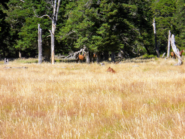 |
| St James Walkway: wild St James Horses from 2015 |
As I said the start of the day is easy travel across expansive grasslands this then turns into a miserable rocky, swampy grovel around the lower slopes of Mt Federation. The track is hemmed in between the Ada River and Mt Federation making for a lot of climbing and descending spurs. This is never good terrain for a track but at least it only takes an hour to get past this section.
 |
| Heading towards Mt Federation on the St James Walkway |
 |
| Faerie Queene from further down the Ada Valley |
 |
| Looking east towards the distant Ada Homestead |
The walk down the Ada Valley is through a mixture of Matagouri and tussock. I could see a lot of wild pig sign around here as well as obvious tracks from the wild horses. The track is well marked with snow poles but the ground path is really obvious and easy to follow.
 |
| Matagouri trees in the Ada Valley, St James Walkway |
 |
| Faerie Queene from near Ada Homestead, St James Walkway |
 |
| End of the Ada River flats near Mt Federation |
Mt Federation juts down to the edge of the Ada River as you make your way past Ada Homestead. The river flats shrink from about 3 kilometers wide to less than 500 meters. From the flank of Mt Federation to the rivers edge would only be 20-40 meters wide at the narrowest point.
 |
| Northern side of Mt Federation (1612) from the St James Walkway |
This is the end of the easy travel for the next hour or so: from this point the track is irritating. It runs up and down the lower slopes of Mt Federation, you are never more than 100 meters from the river but because it is swampy you cannot walk on the river terraces. It is also over grown in a number of spots.
As we say in Kiwiland...noice!!!
 |
| The river flats contract as you start to round Mt Federation, Ada Valley |
 |
| Indistinct track around Mt Federation, St James Walkway |
 |
| Geese on the banks of the Ada River near Ada Homestead |
That is Ada Homestead in the distance on the true left of the river. This area once housed a working sheep and cattle station on leased DOC land between the Spencer Mountains and
St James Conservation Area. It is usually un-occupied only being used when DOC teams have work to do up these valleys.
 |
| Distant view of Ada Homestead, St James Walkway |
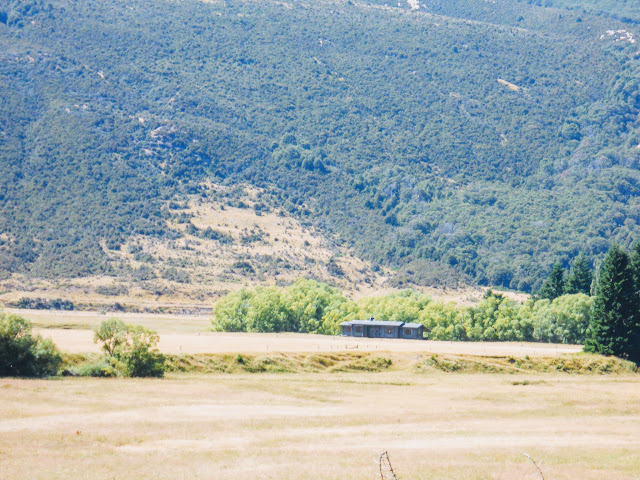 |
| Close up of the Ada Homestead from the St James Walkway (2015) |
There is a limited view up the Waiau River Valley from near Ada Homestead. You can see up the valley towards Waiau Pass and the north eastern edge of Nelson Lakes NP. This is the route the Te Araroa Trail follows so this section of the St James Walkway is very busy over the summer months.
 |
| View up the Waiau River Valley from the St James Walkway |
 |
| View up the Waiau River Valley from beyond Ada Homestead |
You have to climb up the flank of Mt Federation near the Waiau-Ada confluence to avoid swampy terrain. The track weaves in and out of some Matagouri and low scrub. There are a couple of small slips where the track has washed away. I just about fell off the track as it crumbled away beneath me so watch your footing.
 |
| St James Walkway sidles along the bottom of Mt Federation |
 |
| View east along the Waiau River Valley towards McArthur Bridge |
 |
| Last section of the Ada River heading towards Waiau Confluence |
The track from Waiau Pass joins the St James Walkway near Ada Homestead. Te Araroa walkers often need to walk some distance up the Christopher Valley to cross the river. As you can imagine the combined flow from the Ada, Christopher and Waiau Rivers can be substantial at times.
 |
| Another view up the Upper Waiau Valley...route of Te Araroa Trail |
 |
| View down the Waiau Valley towards McArthur Bridge |
 |
| Turning into the Henry Valley from the Ada Valley |
Once around Mt Federation there is a 2-3 hour walk up the Henry River Valley to contend with. In summer take LOT'S of water with you from Christopher Hut/Anne Hut as this section is exposed, hot and bone dry: there is no potable water at all. There are huge numbers of Geese in the Waiau, Ada and Henry Valleys so any river water there is suspect.
This is a massive valley, the far side would be 4-5 km's away at this point.
 |
| On the St James Walkway heading into the Henry Valley |
It was cold and cloudy the day I walked to Anne Hut and the sun did not appear until late in the day. Luckily the worst of the weather was finished so I managed to make it around to the hut without too many difficulties.
 |
| Mt Jervios (1862) lurks under cloud, St James Conservation Area |
 |
| View down the Waiau towards Glenrae Range and McArthur Bridge |
As you make your way up the Henry Valley you cross a succession of low ridges. These look like moraine walls from some ancient glacier. There are a lot of glacial erratic's around...rocks left behind by some retreating glacier. This whole valley is at around 1000 meters so it is very likely there were big glaciers here during the last ice age.
 |
| Old glacial moraine terraces in the Henry Valley |
 |
| View east towards Mt Jervois...St James Walkway |
 |
| Boardwalk over a marsh area...St James Walkway |
The walking through here is easy but tedious as hell...it is up and down over the small ridges with low swampy grasslands in between the ridges. I was happy to climb over the last ridge onto a plateau which stretches from here all the way to the Henry Suspension Bridge.
 |
| The last ridge before the Henry Swing Bridge |
 |
| Looking across a small plateau down towards the Henry River |
 |
| Track markers along the St James Walkway route |
Eventually you connect with an old 4 W/D track half way up the valley- you follow this for the rest the way to the hut and it makes for much faster travel.
 |
| St James Walkway: sign on edge of 4 W/D track in Henry Valley |
Apparently there is a side track connecting the St James Walkway with this 4 W/D track near the Waiau River but I didn't see it. If you can find it use it as it would probably save you 30-40 min's walking time.
 |
| On the Henry Valley 4 W/D track enroute to Anne Hut |
 |
| The 4 W/D track goes all the way to Anne Hut |
You get to a point where a side track veers off the main 4 W/D track and heads towards the patch of Beech forest near the Henry River Swingbridge. It is sign posted but suffice to say look for the junction as it is usually very difficult to ford the Henry River except in sustained dry weather.
 |
| Beech trees mark the location of the Henry River Swingbridge |
 |
| Descending down to the Henry River Swingbridge |
Eventually you reach the Henry Swing bridge...it was quite sporty crossing it. The wind had come up and it was swaying back and forth alarmingly as the wires need tightening. You need to cross this bridge as the 4 W/D ford further up the valley looked deep and swift. The bridge was built because people have died trying to cross the Henry River.
Far better to play it safe and follow the track instead.
 |
| Swing-bridge over the Henry River, St James Walkway |
 |
| Henry River Swingbridge is about 100 meters across |
 |
| View back over the Henry River Swingbridge |
The track on the far side of the Henry Swingbridge is bloody dodgy...a slip has taken away a section and you have to climb over a couple of gaps in the track. A fall would not be good as you are about 20 meters above the river here. I stopped to talk to some DOC workers near here and they said a couple of guys were coming in to blast a new track as it was so dangerous.
 |
| View down the Henry River from the swingbridge |
 |
| Dodgy cliff side track near the Henry Swingbridge, St James Walkway |
After the swing-bridge you walk across some river flats to the 4 W/D track leading up to Anne Hut. The track meanders along the river and then crosses a couple of side streams before emerging near the ford over the Henry River. It is about 1.5 kilometers from the bridge to the 4 W/D track...
 |
| Walking along the Henry River towards the 4 W/D track |
You ascend one last hill on the 4 W/D track onto a flat plateau...it is then a flat 2 km walk to Anne Hut sitting temptingly out on an open plain.
 |
| On the 4 W/D track coming up from the Henry River |
 |
| On the plateau Anne Hut sits on...St James Walkway |
On a hot sunny day it takes an age to cover those last kilometers but with the cloudy conditions it was quite a pleasant stretch on the way to the hut. I could see smoke coming from the chimney and a guy outside chopping wood so I knew there were people in residence.
 |
| First and distant view to Anne Hut, St James Walkway |
 |
| Anne Hut sits on a wide open plateau above the Henry River |
 |
| ...nearly at Anne Hut on the St James Walkway... |
Anne Hut is a total cracker...it is fairly new and nicely repositioned from its old shaded location closer to the Henry River. The old hut was down by the river and in the shade of some tall hills so it was cold and damp. It is a lovely hut and is very popular as the St James Walkway, St James Cycleway and Te Araroa Trail all pass by here.
 |
Anne Hut in the St James Conservation Area
|
There was a new intentions book in the hut left there in late January and it already had 10 pages of visitors marked in it. That is how busy it is over the summer months...
 |
| Anne Hut: interior tables and benches... |
 |
| St James Walkway: Anne Hut...one of the bunkrooms |
 |
| St James Walkway: Anne Hut cooking bench |
 |
Anne Hut: the wood burner is centrally located
|
 |
| St James Walkway: Anne Hut living space |
The hut was rebuilt in 2012 after the old Anne Hut burnt down. It is big: 24 bunks, warm (well insulated), spacious, well appointed with a big wood shed (but no damn wood) and multiple rain water tanks. Very, very nice.
 |
| Gear drying on the veranda at Anne Hut, St James Walkway |
Look at that view, awesome!
 |
| View down Henry River Valley from Anne Hut |
I noted with interest that the hut was connected to the ground with massive concrete piles, which leads me to believe that it must be bloody windy up here sometimes. It must get some shockingly deep snow as the hut is probably at 800-900 meters in the middle of a wide open semi alpine plateau. In the middle of a winter storm it probably has snow drifts up against it.
 |
| View up valley from Anne Hut to Opera Range |
I shared the hut that night with four hunters and a slightly eccentric English tramper. The hunters had had little success as DOC had recently shot most of the deer on the surrounding hills. Seems a bit crazy when the Roar was starting but it was probably some stack of money that had to be spent or lost.
The English guy had been in the country since the end of December and had just been tramping the whole time. He said he comes over every couple of years and spends three months tramping. He had been up most of the valleys on the West Coast including a pile that few Kiwi trampers visit. He had spent the previous night camped up near Anne Saddle.
 |
| Dusk at Anne Hut on the St James Walkway looking east towards St James Range |
 |
| Nightfall Anne Hut looking west towards Opera Range |
There was very limited firewood at the hut so we had a rather meagre fire that night. It was sufficient to warm the hut up and with six people in the hut breathing and cooking it kept it just warm enough overnight. Quite a pleasant night all around with me spending some time talk to the English dude and the hunters.
Come back soon for the conclusion of my St James Walkway adventures where I walk from Anne Hut to the Boyle Outdoor Education Center with a night at Boyle Flat Hut enroute.
Access: From SH 7 (Lewis Pass Highway), the track starts at Lewis Pass Tarns, southern terminus is at Boyle Village.
Track Times: Day one: From Lewis Pass- 2.5 hours to Cannibal Gorge Hut, another 1.5-2 hours to Ada Pass Hut: Day two: 3 hours to Ada Cullers Hut, another hour to Christopher Hut. Day three was a pit day! Day Four: 5 hours to Anne Hut from Christopher Hut
Hut Details: Cannibal Gorge Hut: serviced, 20 bunks, water tank, wood burner, toilets, wood shed: Ada Pass Hut: serviced, 14 bunks, water tank, wood burner, toilets, wood shed: Ada Cullers Hut: basic, 4 bunks, water from stream: Christopher Hut: serviced, 20 bunks, water tanks, wood burner, toilet, wood shed: Anne Hut: serviced, 24 bunks, water tanks, wood burner, toilets, wood shed
Miscellaneous: Severe avalanche risk in Winter/Spring, some un-bridged side streams. The walkway is in a high alpine area and as such is prone to extreme weather.


