On the Christchurch Coastal Pathway...
I revisited one of the Christchurch 360 Trail sections I last walked way back in September 2016. The section I walked was the Christchurch Coastal Pathway from Scarborough to Mt Pleasant. Back in 2016 I had no YouTube channel so I wanted to get some film for a vlog about this very nice trail section. I am in the process of doing this for all the 360 Trail sections I have previously covered.
 |
| Sumner Beach from atop Cave Rock |
This pathway is mostly on footpaths but it is actually quite nice as you have water right next to you for the whole length of the trip. Along the way you pass through Scarborough, Sumner, Moncks Bay, Redcliff's and Mt Pleasant all suburbs on this side of town.
 |
| Scotts Park at the base of Mt Pleasant |
 |
| Christchurch Coastal Pathway starts from here |
I parked my car at the Scott Park car park and set out for points east.....
I jumped on the No. 3 bus to Sumner from the bus stop about 100 meters away on the main road heading out to Redcliff's, Sumner and Scarborough. You can clearly see this from the carpark...the bus arrived about 10 minutes after I arrived so the wait was very short.
 |
| On the bus to Sumner to walk the Christchurch Coastal Pathway |
The bus can take you to the center of Sumner Village outside the shops. From here you engage shanks pony and walk down to the start of this Christchurch 360 section down by the Coast Guard Station at Scarborough.
There are several cafes in Sumner as well as a small supermarket, a bakery, takeaways, toilets etc. I stopped at the supermarket to get some eats for the walk and a cold drink.
 |
| In the center of Sumner Village on Marriner Road |
 |
| Walking along the Esplanade towards Scarborough |
This section starts at Scarborough near the Coast Guard Station. From here you can walk back to the carpark at Scott Park, catch a bus (in Sumner township) to Mt Pleasant or continue along the next section of the 360 Trail to Taylors Mistake.
 |
| Christchurch 360 logo down at Sumner Bay |
 |
| Looking across to Cave Rock from Heberden Road Scarborough |
The tide was out and it was super calm at Sumner Bay on the day I walked the pathway. Normally there is a stiff breeze blowing which is why it is a good surf beach. You are walking down Heberden Avenue towards Scarborough Fare which is the restaurant on this end of the Esplanade.
There are a couple of Christchurch 360 information panels/maps next to Scarborough Fare but they are not so easy to see as they are right next to an overgrown tree. They are directly above the kids waterpark....
 |
| Scarborough Fare is on the Esplanade at Scarborough |
 |
| Godley Cliffs map for Christchurch 360 Trail |
 |
| Estuary-Marshes map for Christchurch 360 Trail |
The Esplanade runs from Scarborough right down to Sumner and its elevated location atop the seawall means you have excellent views out to Pegasus Bay. It was a clear day with a gentle breeze blowing in off the sea...perfect conditions for a walk.
 |
| Sumner Bay shimmers in the afternoon sun |
 |
| On the Esplanade looking to Cave Rock |
From the seawall you can see down to Cave Rock at Sumner and also back to the hillside suburb of Scarborough. Looking out to sea there are excellent views along the beaches of Pegasus Bay right out to the horizon.
 |
| It was low tide at Sumner Bay, Sumner |
 |
| Park land backing the seawall along the Esplanade, Sumner |
Cave Rock has been out of bounds for quite a long time due to earthquake damage and rock fall risks. I was pleased to see it is now open for visitors. Go up to the top for the awesome views of the surrounding area...
 |
| Cave Rock is an ancient volcanic outflow |
There is a short but fairly steep path up to the top of Cave Rock ( it is surprisingly high on top of that chonk of rock) from where you have vistas in all directions. Back down the Esplanade to Scarborough and across Sumner Beach to Gallen's Point. You can also see up to Evans Pass at the head of Sumner Valley and right along the coast.
 |
| Signaling tower on the top of Cave Rock |
 |
| View along the Esplanade from Cave Rock |
There was a solitary seagull taking station on the top of Cave Rock warily looking around....
 |
| A solitary seagull watches from the top of Cave Rock |
 |
| Sumner Beach stretching out to Gallen's Point |
There is a historic signaling tower on the top of Cave Rock which was used to control coastal shipping in the 1800's. Sailing ships and small steamers would often anchor in Moncks Bay to unload passengers and cargo. Bear in mind that the entrance to the Avon-Heathcote Estuary used to be 3-4 times wider and deeper than it now is...
 |
| View along Southshore Spit from the top of Cave Rock |
 |
| Closer detail of the signal tower on Cave Rock |
 |
| Memorial plaque on the signal tower at Cave Rock |
 |
| The climb up Cave Rock is steep and rocky...take care!!! |
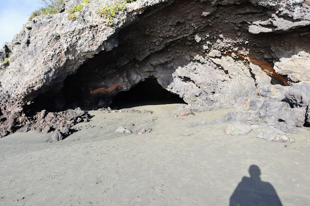
You can now walk through the cavern inside Cave Rock once again. It was closed for a long time as large chunks of rock fell off the roof during the Christchurch Earthquakes. Someone must have decided that the risk is now passed...
 |
| Cavern running through Cave Rock at Sumner |
 |
| Side portal for the Cave Rock cavern |
From Cave Rock you are heading along the side of Main Road into Sumner back around the bays to Mt Pleasant. You walk past the Beach Bar on the edge of Sumner Beach and along the footpath heading towards the Sumner Surf Lifesaving Club.
FYI: There is a takeaway shop opposite Beach Bar that sells American style hotdogs with all the trimmings. Karen and I often come here for lunch when we are visiting the beach. I loves me an American style hot dog in a steamed bun with relish, mustard and a side of salty chips...
 |
| Beach Bar is a café at Sumner Beach |
There was a wedding going on at Sumner Beach...I passed the groomsmen on the beach and the bride walked past me as I headed out of Sumner. She was wearing a traditional Chinese wedding dress in bright red for good luck, happiness and prosperity...
 |
| A Chinese bride goes to meet her groom at Sumner Beach |
Continue along the Esplanade past the surf club and walk down towards Gallen's Point and Shag Rock. Along the way you will pass a series of memorial light posts with the names of famous battles Kiwis fought in during WWI. Messines, Somme, Falkland Islands, Passchendaele and Beersheba were some of them...
 |
| Memorial light post along the Esplanade at Sumner Beach |
There is a set of public toilets at the Sumner Surf Lifesaving Clubrooms...the next are down at Barnett Park in Redcliff's.
 |
| Toilets at the new Sumner Surf Lifesaving Clubrooms |
 |
| Christchurch Coastal Pathway sign in Sumner |
The new Surf Lifesaving Club at Sumner looks flash! I really like the shape and use of wooden cladding as it fits in well with the local environment...I wish more new buildings were like this.
 |
| The newish Sumner Surf Lifesaving Clubrooms |
The ridge between Sumner and Moncks Bay is known as Gallen's Point...it marks the boundary between the two suburbs. There is a set of seats on the point where you can look out over Sumner Beach and the mouth of the Avon-Heathcote Estuary.
 |
| Seating area near Gallen's Point with views of Sumner |
 |
| Last view along Sumner Beach to Scarborough |
You can see why there have been various schemes over the years to build a bridge from Sumner to Southshore. The mouth of the Estuary is only about 40 meters wide at low tide. Unfortunately it is about the same depth with a changeable channel so any bridge would be awesomely expensive. It is unlikely to be built in my lifetime.
 |
| First view of Shag Rock from the Christchurch Coastal Pathway |
As you round Gallen's Point you pass Shag Rock which was a rock pillar just off the coast. It used to rise about 10-15 meters from the beach and was surrounded by water at high tide. Now it is just a pile of rubble as it was destroyed in the 2010/2011 earthquakes. We in Christchurch have cheekily taken to calling it "Shagged Rock".
Its gallows humor really as it is actually quite sad to lose such a beloved landmark!
 |
| Closer view of Shag Rock from the Christchurch Coastal Pathway |
 |
| On the Christchurch Coastal Pathway looking to Moncks Bay |
Not all parts of the Coastal Pathway are completed as the section between Moncks Bay and Redcliff's is still under construction. There isn't a whole lot of space along here so they are building a seawall from near the Yacht Club to Shag Rock and the pathway will run across the top of it...
 |
| You must cross to the opposite side of Main Road |
 |
| Succulent plant along Main road in Moncks Bay |
 |
| View of the Avon-Heathcote Estuary from Moncks Bay |
Here is one of the new seawall sections under construction right next to the Moncks Bay Yacht Club. They have built a coffer dam and are infilling the space behind it. This will add about 2-3 meters of space right around to Shag Rock. This will allow for separation of the walking and cycling track from the road.
 |
| New seawall under construction at Moncks Bay |
I stopped for a filled wrap and drink just past the Moncks Bay Yacht Club at Barrett Park in Redcliff's. There are a couple of spots along here where you can stop for a rest with views out over the estuary. My roast beef wraps were from the supermarket in Sumner...they were yum BTW!!!
 |
| Main Road in the suburb of Redcliff's |
 |
| ...lunch time at Barnett Park in Redcliff's |
I have fond childhood memories of Barnett Park as we often went there for picnics and day trips. It has a playground and a area of thick native planting we used to run through. There is a very nice walk up the nearby valley to a cave that almost became the Christchurch portal for the Lyttelton Road Tunnel. It takes about 1.5 hours return to walk to the cave and has some awesome views...
 |
| Barnett Park in the suburb of Redcliff's |
The 360 Trail goes back out onto the main road for a couple of hundred meters taking you through the shops at Redcliff's. There are two convenience shops, two cafes and a couple of other specialty shops here if you need anything. From the Redcliff's shops you turn right down Beachville Road to walk alongside the Estuary.
 |
| ...in Redcliff's turn right into Beachville Road... |
 |
| Heading down Beachville Road to the Estuary |
 |
| Beachville Reserve at Redcliff's is a good lunch spot |
You can look out at Moncks Bay, Avon-Heathcote Estuary and over to Southshore and Shag Rock as you walk along Beachville Road.
 |
| Moncks Bay from Beachville Reserve |
The Coastal Pathway runs along the top of a seawall built to protect Redcliff's from erosion by the tides. I would love to live out here with those views but you would have to think seriously about buying any home this close to the ocean. It will probably be under water within the next 20 years.
 |
| Christchurch Coastal Pathway along Beachville Road |
 |
| ...distant Southshore from the Beachville Road seawall... |
 |
| Clifton Spur rises above Moncks Bay |
 |
| ...the end of the Southshore Spit from Beachville Road... |
 |
| Heathcote-Avon Estuary from the Beachville Road seawall |
Beachville Road runs right around the outside of this suburb and eventually ends up back on the McCormack's Bay Causeway. On the way there you pass the new Redcliff's school that was shifted after the Earthquakes. You also pass a short jetty that goes out into the Estuary.
 |
| Small jetty to Estuary opposite Redcliff's School |
 |
| Looking southwest across the Heathcote-Avon Estuary |
 |
| Redcliff's School in the suburb of Redcliff's |
The Estuary down here is much wider and Southshore, South Brighton and Brighton are just visible a couple of kilometers away on the other side of the mudflats. The Estuary is full of wetland birds and you will see many different species wading about the edges. It would be a great location for bird watchers...
 |
| Wetland birds wading on the shore of the Estuary |
 |
| Pathway out to the McCormack's Bay Causeway |
The penultimate section of this walk is across the McCormack's Bay Causeway from the edge of Redcliff's to the bottom of Mt Pleasant Road. The route is along a cycleway/walking path with the road on one side and the Estuary on the other. You are on the last 1.5 kilometers of your trip...
 |
| McCormack's Bay Causeway links Redcliff's to Mt Pleasant |
 |
| Christchurch 360 logo on pole at McCormack's Bay |
There are a series of information panels along the pathway with historical information and notes about future developments envisioned for the estuary such as bird watching hides. They have been there since 2016 so I assume progress on the project has stalled...good olde Covid again!!!
 |
| Information panel along McCormack's Bay Causeway |
I spotted a few birds along this area...shags, herons, ducks, geese and seagulls mostly and also some shoals of fish swimming around just off shore. The tide was coming in so the estuary was slowly filling with water and the mudflats and sandbars disappeared under the water...
 |
| Shag drying his wings at McCormack's Bay |
 |
| Tidal sub estuary at McCormack's Bay |
There are bus stops at the bottom of Mt Pleasant Road so this can be a good spot to jump on/off. There are a closer set of stops about 100 meters from the Scott Park carpark.
 |
| Christchurch Coastal Pathway at Mt Pleasant Road |
 |
| ...there are bus stops opposite each other on this route... |
 |
| Group of Shags in the sun at Mt Pleasant |
It takes a long time for the tide to reach the head of the estuary so as you can see in the photo below there were still mudflats visible. By the time the water has reached this end of the Estuary the rest will be filled to the brim.
 |
| Upper Heathcote Estuary near Ferrymead...mid tide! |
All up it took me about two hours to take the bus to Sumner, walk down to Scarborough and then walk back to my car at Mt Pleasant. This could be covered more quickly if you ride a bike as it is a dual cycle/walking track in which case it would take about an hour.
 |
| The closest bus stop to Scott Park is at The Brae |
 |
| ...last 100 meters to Scott Park at Mt Pleasant... |
 |
| Silver Surfer parked at the Scott Park car parking area |
I have previously walked out to Scarborough and then back to Mt Pleasant and it was an enjoyable if long day. If you don't fancy the idea of walking all the way to Scarborough and back then just jump on the No.3 Sumner to Airport bus and only walk one way. The bus comes through every 15 minutes and will cost $2.00-$3.50 depending on your age.
 |
| Toilet block at Scott Park where I parked my car |
The Coastal Pathway is a very nice trip...how many times have you driven this way but never actually walked it? I recommend everyone get out there and give it a go, just pick a lovely sunny day like I did. Take sunscreen as there is zero cover the whole way and warm clothing as it can be a bit cold in the wind.
Christchurch 360 section details: Mt Pleasant to Scarborough
Access: Start at the Mt Pleasant Yacht Club, ends at the Scarborough Surf Club
Track Times: Approximately 7 km's, 1-2 hours one way
Miscellaneous: No.3 Sumner-Airport bus covers this whole section if you want to park at one end and catch the bus back to your car. There are toilets at both ends of the section and at Barnett Park. There are shops right along this route.
Christchurch 360 Trail: Taylors Mistake to Scarborough-Coastal Walkway: Mt Pleasant to Scarborough - Mt Pleasant to Travis Wetlands Section


