Back into the Nina Valley
I have wanted to get back up the Nina Valley for some time now, the last time I was in the area was back in 2016 nearly 6 years ago. I wanted to travel up the valley to make a vlog of the track and to revisit the excellent Nina Hut.
 |
| Nina Hut, Lake Sumner Forest Park |
 |
| Beech forest in the mid reaches of Nina Valley |
Looking back through the blog the last time I was here was in 2016 so it has been nearly six years since I visited this valley. That is too long to miss this lovely terrain but I just have so many tracks to walk it is sometimes difficult to revisit locations.
 |
| NZDA Palmer Lodge on SH 7, Lewis Pass |
I headed up early on Friday to try to avoid the crowds of the weekend and arrived at the NZDA Palmer Lodge around 9 in the morning. This is a moderately safe place to leave your car, and the closest parking area to the Nina Valley Track. The New Zealand Deerstalkers Association have a number of huts around the country and they can be used by members and visitors for a modest fee.
 |
| ...Palmer Lodge is the start point for the Nina Valley... |
There is a large flat area at Palmer Lodge for parking vehicles but be aware that car break ins and thefts are common all along this highway. The safest parking would be at the
Boyle Outdoor Education Centre and either get them to drive you to the track end or hitch to this point. I have never had any problems as I think the presence of Palmer Lodge might put off the the vandals.
 |
| Mt Norma from near Palmer Lodge |
The interior of Palmer Lodge reminds me of old Kiwi Bach's I have stayed in...old furniture, a wood burner, bunk beds and a minimal level of comfort. It would provide shelter from a storm so it is doing the business...
 |
The interior of Palmer Lodge
|
There is some good Red Deer, Chamois and Thar hunting to be had in the area and the Lodge will be busy and occupied especially during the roar when hunters flock to these hills.
Heading to the Lewis River swing bridge
The Nina Valley track starts from the Lewis River swing bridge, it is across SH7 and 100 meters up the road from Palmer Lodge. Take care crossing the road as there is a lot of fast traffic on this road at all times of the day and night.
 |
| Another vehicle parked opposite the Nina Valley |
 |
| Start of the Nina Valley Track on SH7 |
There is a sign on SH7 the start of the track there is a more informative notice just inside the bush edge showing all of the tracks and huts in the area.
 |
| The track leads down to the Lewis River |
 |
| Looking up SH 7 towards Lewis Pass |
There is a swingbridge within 50 meters of the start of the track across the Lewis River and the true start of the Nina Valley Track is on the true right of the bridge.
 |
| Lewis River swingbridge, Lake Sumner Forest Park |
 |
| Crossing the Lewis River swingbridge |
 |
| DOC maps and intention kiosk next to Lewis River |
Stop on the far side of the bridge and adjust your gear before setting off along the track.
On the Nina Valley Track
The Nina Valley track gives you access to various locations up this valley including Nina Hut, Lucretia Stream, the Devils Den route, Mt Norma and Mt Boscawen. Generally it is a good track but it can be very muddy if there has been any significant rain.
 |
| Map of this section of Lake Sumner Forest Park |
On the far side of Lewis River are a couple of information boards and an intentions kiosk check the intentions book to see how many people are visiting the hut. Nina Hut is a 10 bunker, a flick through the hut book showed multiple occasions when there were up to 20 people staying there....
If it is busy take a tent or go somewhere else...I suggest Manson-Nichols Hut at Lake Daniell over Lewis Pass or Cannibal Creek Hut the first hut on the St James Walkway.
 |
| Intentions kiosk and information panels at Lewis River |
 |
| My trekking poles at the Nina Valley Track |
There is a board about the DOC/Hurunui College/Forest and Bird joint kiwi/kaka/whio recovery in the valley...they run a very successful pest trapping program. The number of native birds in the valley has increased significantly including nearly 20 introduced kiwi.
Damn fine work they are doing!
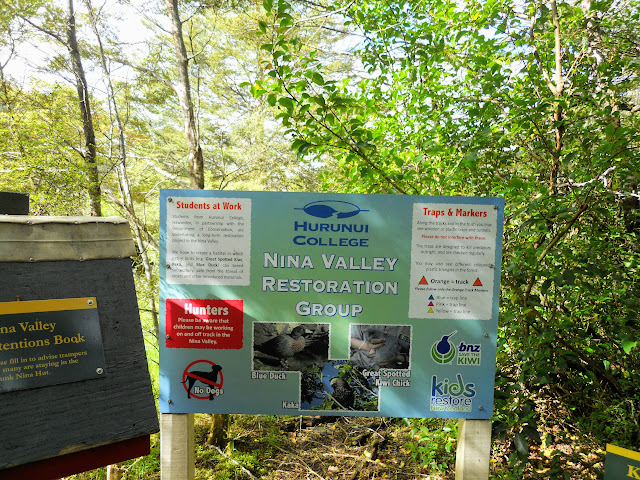 |
Hurunui College information board in Nina Valley
|
To start the track runs over an old river terrace through nice beech forest which is well marked and easy to follow.
 |
| General condition of the Nina Valley Track |
 |
| Walking across a Beech covered river terrace, Lake Sumner Forest Park |
Further along the track there is a heavy layer of moss on the ground which is very attractive.
 |
| Start of the first climb on the Nina Valley Track |
You have a great view down to the Lewis River from about 600 meters along the track. The bush is open at this point with several detours to avoid places where the track has fallen into the river. You would be about 30 meters above the river at this point.
 |
| Lewis River from the Nina Valley Track |
 |
| Nina Valley Track heads away from the river |
The forest is a mix of Beech species with Red Beech, Black Beech and Mountain Beech the main types.
 |
| Mixed type Beech forest, Nina Valley Track |
 |
| Goblin forest along the Nina Valley Track |
It was very dry the day I visited but I did slip off a log along a shallow stream and sank up above my ankle into the mud. It was quite difficult to get free and I had to take my pack off and throw it to dry ground to get up. I had to wash my leg and foot off in a nearby stream...
 |
| ..muddy foot after slipping off a log... |
About 15 minutes down the track you climb up and over an ancient rock slip, now clothed in forest. The rock have come down off nearby Mt Norma and there is a side track to the top of this 1600 meter peak. There are patches of moss covered goblin forest in this area.
 |
| Climbing over the old rock slip, Nina Valley Track |
 |
| You climb over this spur...Nina Valley Track |
 |
| The Nina Valley Track is stony and full of roots |
The track then descends to an large river terrace this is by far the wettest and muddiest section of the track...if it has been raining expect to get dirty. Lucky for me the West Coast has been dry for about a month now so it was relatively easy walking.
 |
| Side stream along the Nina Valley Track |
 |
| Heading onto the old river terrace...Nina Valley Track |
There is an open stretch of Beech Forest for the next two kilometers and this is the only place where you can make good time on this track. The ground is mossy and the track meanders through the trees on its way to the Nina River.
 |
| More open forest on the terrace, Nina Valley Track |
There are areas of the track through this muddy section covered in what the Americans would call corduroy. This consists of old logs laid side to side through the worst mud which people walk on top of. It is a cheap and effective way to maintain a track.
 |
| Track corrugation along the Nina Valley Track |
 |
| ...the Nina Valley Track is indistinct here... |
 |
| On the western edge of the old terrace, Nina Valley Track |
There is a turn off near the southern end of this river terrace to the Sylvia Tops Route. The route goes from Devilskin Bivouac along the Sylvia Tops and then drops down to the Lewis-Nina River confluence. I have seen vlogs of the route and it looks awesome...on my 'to do ' list for some time now...
 |
| Turn off for the Sylvia Tops Route, Nina Valley Track |
Past the mud you head back into beech forest, Red Beech in this case, the rest of the track is either forest or open river flats. You get a few glimpse of the Nina River but mostly you are several hundred meters away from it as you head to the Nina River swing bridge.
 |
| Nina Valley Track near Pt. 628 |
Be aware that you need to cross eight side streams to get to the hut, a problem if heavy rain is coming as 3-4 of them could flood enough to trap you up valley. If you cannot cross the first stream then head back to the start of the track as there are larger side streams further up the valley.
 |
| One of several side streams on the Nina Valley Track |
 |
| ...this stream comes down off Mt Norma... |
 |
| ...it was shady amongst the trees, Nina Valley Track... |
After about an hour you get your first view of the Nina River as it flows past the track heading down to the confluence with the Lewis River.
 |
| First view of the Nina River from the track |
 |
| Heading down to the first river flat...Nina Valley Track |
At one point the track drops down to the river for a short while. There is an official backcountry campsite marked on the Topo map fat this site. There are loads of great camping spots in this valley if that was your interest.
This is a very basic back country camp-site: i.e.. no toilets, no fire pit or other structures....just open space for your tent!
 |
| First river flat on the Nina Valley Track |
 |
| An excellent swimming pool in the Nina River |
There is a bridge over the Nina Valley about an hour into the journey. While the bridge itself is impressive the deep emerald green river pools are spectacular. The rest of the journey to Nina Hut is on the opposite or 'true right" side of the Nina River.
 |
| Nina River Bridge, Nina Valley Track |
 |
| The bridge has a solid base...Nina River Bridge |
 |
| Looking to the far bank at the Nina River Bridge |
There is a track from the swing bridge to Lucretia Stream which goes up the true left side on the Nina River. Lots of good camping on the river flats about 30 minutes up that track. This will probably be my next trip destination in the valley.
 |
| Track marker for Lucretia Track to rear of sign |
I stopped at the track junction at the suspension bridge over the Nina for a 10 minute break. From here you turn right and cross the bridge for Nina Hut. If you stay on this side of the river you will continue to the Lucretia Valley Track and the
Upper Nina Biv (2 person) at the head of the valley.
 |
| It is 2.5 hours to Nina Hut from here |
The track to the Upper Nina Valley is a lot rougher, with three un-bridged stream crossings it does not get the same amount of traffic as the track to Nina Hut. The best way to access it is to follow the Nina Hut Track and then cross the Nina River up by the hut.
 |
| My Osprey 50 AG at the Nina River Bridge |
The suspension bridge over the Nina is in a lovely spot with very deep (and I'm informed really cold pools under it). The bridge is relatively new (2002), previously travel to the Nina Hut or points up valley would have required a river crossing higher up the river.
 |
| View from the true right of Nina River Bridge |
 |
| Cable stay on the Nina River Bridge |
 |
| Mt Norma rises behind the Nina River Bridge |
The track from here to the hut sidles the side of the Sylvia Tops ridge...it is about 1.5 to 2 hours to the hut from the bridge. Most of this track looked familiar but there are many places where the track has been re routed away from the river. This is to avoid the eroding river bank but some areas look like attempts to avoid the legendary mud on the old route.
 |
| Nina Valley Track from the bridge |
 |
| The Nina River is off to the right of the track |
 |
| Western end of the Nina River Gorge |
 |
| The Nina Valley Track heads away from the river |
Below is a photo of one of the re routed track sections, this one is long, it must go for about a kilometer and is about 100 meters further away from the river than it used to be. The old track had a lot of river bank erosion along it which I imagine is why it has been re routed.
 |
| On the newer section of the Nina Valley Track |
 |
| The Nina Valley Track sidles along the Sylvia Tops Range |
 |
| Looking back along the Nina Valley Track |
There are a few of these wide grassy terraces which would make ideal camp sites. The track starts to gradually climb up the ridge on which the hut sits. From the flats you are about 2 km away from the hut although it seems further.
 |
| River flats along the Nina Valley Track |
 |
| Lucretia Stream is opposite the Nina River flats |
 |
| View back down the Nina Valley |
The river flats are interspaced with fingers of Beech trees which would provide shelter from wind and firewood.
 |
| Bush fingers interspace the river flats...Nina Valley |
I stopped for a snack about 45 minutes up valley and enjoyed my favorite tramping snack; a box of raisins...yum! I like a sweet/savory snack mix so I favor raisins/steak bars/snickers/salted peanuts/M&M's and cheese sticks.
I'm not big on muesli bars (they taste like sawdust to me) the only ones I can eat are the Flemings ones with yogurt on them.
 |
| Resting spot along the Nina Valley Track |
There are a couple of good flowing streams along the side of the track which can be used to resupply with water if required. I would treat/filter it as a lot of people walk up and down this valley.
 |
| Stream crossing the Nina Valley Track |
 |
| ...this stream comes down off the Sylvia Tops... |
This likely looking fellow swooped down to check me out when I stopped for a drink and boot adjustment. You often have companionable Bush Robins visit you in New Zealand beech forest they are after the bugs you disturb as you walk along.
 |
| South Island Robin investigates my pack |
 |
| South Island Robin in the Nina Valley |
There is one last side stream crossing the track at the base of the last climb of the day...from here you are climbing up the sided of a knob to the hut. Get water here for the climb as it is the last source till the hut itself...there are water tanks at the hut.
 |
| Cascade along the Nina Valley Track |
 |
| Last stream before climbing to Nina Hut |
 |
| ...this stream can flood in heavy rain... |
Nina Hut sits on a knob 3/4 of the way up the valley, it was an inspired spot as it is so sunny. The last kilometer to the hut is a gentle climb to the flat area the hut occupies and is characterised by moss draped 'goblin forest".
 |
| Gentle start to the climb to Nina Hut |
 |
| Nearing the top of the knob Nina Hut occupies |
Once you reach the top of the knob you have to walk along the crest for a hundred meters to the clearing the hut sits in.
 |
| Walking along the knob to Nina Hut |
I finally reached the hut after 3.5 hours which was good progress given the muddy state of the track.
 |
| First view of Nina Hut from the edge of the track |
Eventually you arrive at
Nina Hut which is perched on the crest of a small outlier knob in a natural clearing. This hut was built in 2002 to replace the old and cold hut on the other side of the river. Apart from the resident sand-flies it is a fantastic spot; warm, sunny with views to all the surrounding mountain ranges.
 |
| Nina Hut, Lake Sumner Forest Park |
 |
| Someone is in residence at Nina Hut...boots!!! |
 |
| Nina Hut: the wrap around veranda |
 |
| Looking back down the Nina Valley past the hut |
I ended up sharing the hut with only three other people which is unusual for this hut as it gets a lot of use. I imagine the sketchy rain forecast put a lot of people off - it was supposed to rain that night but in the event it was fine, dry and warm. They were a father with his two children at the end of a week long traverse of the Lewis Pass Tops and Sylvia Tops.
 |
| There is a wheelbarrow for moving firewood |
The interior of the hut is in excellent condition given the number of people who visit. There are no bunks in this hut, instead there are two sleeping platforms to maximise capacity. The hut will sleep 10, with a couple more on the floor if needed. I took my usual position, up against a wall so that I can lean against it as I read my book.
 |
| Nina Hut: the sleeping platforms |
First order of business, as always, was a brew of tea. This is always the first thing I do when I get to a hut...good old tea revives on both hot and cold days.
While the water was boiling I set up my pit for the night ahead.
 |
| Nina Hut: the steel cooking bench |
You can see how sunny the hut clearing is, the old Nina Hut was on the true left of the Nina River just before Duchess Stream so it was cold, damp and miserable for much of the year.
This is so much better.
 |
| Nina Hut is a standard 10 bunker |
 |
| Good view of veranda at Nina Hut |
 |
| Nina Hut: view from the west |
There are some excellent views of the surrounding mountains from Nina Hut. You can see up to Devilskin Saddle and the Sylvia Tops, up the valley towards Mt Boscawen and across to Duchess Stream and the Lewis Pass Tops.
 |
| View up to Devilskin Saddle, Nina Valley |
 |
| Mt Hatless (1660) from Nina Hut |
 |
| View up Duchess Stream to Lewis Pass Tops |
I spent the afternoon around the hut cutting up firewood, talking to my hut companions, drinking tea, reading and generally loafing about...
 |
| Nina Hut from the track to Devilskin Saddle |
Another view of the hut from the far end of the clearing, the views are very nice, unfortunately you are a fare distance from the Nina River, a trip to the river would require a moderately long trip. There is a side track at the back of the hut down to a ford over the Nina River and thence to the Upper Nina Valley.
Plenty of space for a tent if the hut was full but the sand-flies would eat you alive. I would always take a tent when visiting Nina Hut as it is one of the most well used in Canterbury and there may not be a bunk for you.
 |
| Space for camping around Nina Hut |
You can see right up Duchess Stream to the tops and this is a route many trampers use to gain access to the Lewis Pass Tops.
 |
| A good view up Duchess Stream |
 |
| Pt. 1622 on the Lewis Pass Tops |
There is a wood shed at the hut which is normally empty and a fire pit for the campers to use. No fires were required as it was so warm and there is a fire ban on in the Lake Sumner FP at the moment.
 |
| Firepit outside Nina Hut |
 |
| The woodshed at Nina Hut |
There was a fine selection of boots outside the hut and for once every one of us including the kids were wearing Lowa's. I have been using Lowa Ranger IIIs for about a decade now and I will be looking to buy another pair soon as the sole on my current boots are wearing down. I have been wearing this pair for five years now so that is not bad wear.
 |
| Many pairs of Lowa's lined up at Nina Hut |
 |
| The hut sign on the watertank at Nina Hut |
 |
| Nina Hut: the sink and water tap |
The hut toilet is just down the valley track from the hut and it is a classic longdrop. Not the most salubrious toilets but sturdy and functional.
 |
| Orange triangle on the Nina Valley Track |
 |
| Classic long drop toilet at Nina Hut |
I spent most of the afternoon reading my Kindle and because there were only four of us in the hut I had my 'pile o' mattresses' for extra comfort. It was a warm day so we didn't need the fire that evening.
It rained overnight but it was a very fine rain so it didn't do much more than fill the watertank a bit over night. I heard a couple of Ruru during the night but no Kiwi like the last time I was here.
Day Two: Return to Palmer Lodge
We all had a late start the next morning and i was not up and moving around until about 8 am which is very late for me. I had a leisurely breakfast and then we all chipped in to get the hut tidied up before we left. All of us were heading for the end of the track and home.
 |
| Mt Boscawen (1780) at the head of the Nina Valley |
The kids helped out with the clean up and it was great to see a family group out enjoying the backcountry with such obvious relish.
 |
| Cleaning Nina Hut before we leave |
 |
| Firewood for the next visitors to Nina Hut |
 |
| Nina Hut: benches stacked on the table |
Another view of the hut interior, good firebox (not required as it was 27 degrees) and the cooking bench/table. The big blue box contains Hurunui High School equipment: tools, traps, bait etc. for the trap lines they run up this valley.
 |
| Nina Hut: Woodburner and the bench space |
 |
| Nina Hut: tidy condition of the mattresses |
 |
| ...Last look inside Nina Hut... |
On the way back to the car I followed the exact same route as the previous day. Travel down valley was quick, it is just about all downhill on the way out of the Nina Valley.
 |
| Back on the Nina Valley Track to the road |
 |
| Sun dappled forest floor...Nina Valley Track |
 |
| Heading back along the knob Nina Hut occupies |
I had contemplated crossing the Nina River and following the old track out down the true left of the river but it was just too hot to contemplate any bush bashing involved. I was also unsure of the river crossing as it had rained a bit over night. I'm very cautious about river crossings, that is how most people come to grief in the NZ bush.
 |
| Heading back down the knob...Nina Valley Track |
 |
| Cool and shady amongst the trees...Nina Valley Track |
This stream is about 500 meters from the hut, if it was raining heavily this is the one that would stop you getting to the hut. It is shallow in this photo but has an obvious flood plain either side of it. I imagine in a really big deluge it could be a raging torrent.
 |
| Stream about a kilometer from Nina Hut |
 |
| Nina Valley Track continues past the stream |
 |
| A small cascade on the side stream...Nina Valley Track |
I was a case of following the track down valley with the occasion view down to the Nina River about 80-100 meters away. The track is just up hill from the river bed for most of the way back to the bridge.
 |
| View down to Nina River from the track |
 |
| Tree roots cross the Nina Valley Track |
 |
| You climb up this rock face...Nina Valley Track |
 |
| Moss covers many of the trees in mid reach of Nina Valley |
It is a bit hard to see but there is a South Island Robin on the trunk of the tree...I saw many Robins up the Nina Valley which is the positive result of the trapping program. Where there is a sustained pest trapping program the bird numbers start to grow.
 |
| South Island Robin on this Beech tree |
The side streams are your way points along the valley...there are four from the bridge to the hut. They are roughly one kilometer apart so you can judge your progress along your map by counting them.
 |
| The stream opposite the Lucretia Valley...Nina Valley |
 |
| Climbing up out of a stream on the way to the bridge |
Eventually I reached flat ground and a short section of forest heading for the grassy river flats just above the Nina River Gorge.
 |
| End of the sidle track along the Nina River Track |
 |
| Back on the flat ground above the Nina River Bridge |
I stopped for a 5 minute break on the edge of the flats and then got under way once I had a snack and some water. I had been walking for just over an hour at this point with another hour to get me to the big bridge over the Nina River.
 |
| Looking out to the river flats, Nina Valley |
 |
| The only muesli bars I can stomach...Flemings yogurt covered |
I passed a hunter heading up the valley just coming onto the flats and he was the first person I had seen since leaving the hut that morning.
 |
| One of the river flats along the Nina Valley Track |
 |
| In a tongue of beech in the Nina Valley |
 |
| Heading to the largest of the river flats...Nina Valley Track |
If you were going to camp on these river flats the best spot would be at either end of the largest flat at the end closest to the Nina River Bridge. There is an expanse of flat ground with trees for cover and the river along here is easily accessible. You are more or less opposite Lucretia Stream in the shadow of the Sylvia Tops.
 |
| Looking down the Nina Valley towards the Libretto Range |
 |
| Plenty of campsites along the Nina Valley Track |
 |
| One of the spurs off Mt Norma, Nina Valley |
There was a good covered camp site at the northern end of the river flats with a stack of firewood drying against a tree. The trees here are small and low so you are less likely to get squot by one falling on you.
 |
| Good sheltered campsite, Nina Valley Track |
Then it was onwards as I walked the last kilometer to the Nina Swingbridge.
 |
| ...on the last kilometer to the Nina River Bridge... |
The river is about 50-100 meters away from you all the way down to the bridge and you can hear it roaring away in the distance.
 |
| The Nina River is 50 meters that way |
 |
| Last slight climb up to Nina River swingbridge |
You are about 200 meters from the bridge when you pass an old rock formation between the track and the river...it is the start of the gorge of the Nina River.
 |
| ...200 meters to Nina swingbridge... |
 |
| Rock outcrop marks edge of Nina Valley Gorge |
 |
| River flats above Nina Swingbridge |
 |
| Classic DOC orange trail marker |
Back at the trusty suspension bridge, the return trip always seems to take a shorter amount of time, I suppose because you know how far you need to go.
 |
| Back at the Nina swingbridge |
I struck a group of four trampers here who were going up to the Devil Skin Saddle for a day trip. That is a heinous day trip as it is at least 5 hours from the bridge to the saddle and then 5 hours back to this point. Given it was already 12 noon they were going to be walking back in the dark...
 |
| Nina swingbridge from true right of river |
 |
| Crossing the Nina swingbridge |
 |
| Pools down stream of the Nina swingbridge |
I stopped for another break on the far side of the Nina swing bridge, just enough time for a drink, adjustment of gear and a "comfort" stop. As I was sitting here I got to thinking about the possibility of pack rafting or floating down the Nina River...it seems to me it would bear some investigation.
 |
| Rest spot next to Nina swingbridge |
From the bridge it is about four kilometers or 1.5 hours to the bridge over the Lewis River.
 |
| ...It is 1.5 hours back to SH7... |
 |
| Last view of the Nina Valley swingbridge |
I had a talk to the people heading up to Devilskin Biv and after they crossed the bridge I packed up my gear and start off along the last section of the track.
 |
| On the Nina Valley Track to the campsite |
The area below is a small river flat 10 minutes from the swing-bridge and is marked on the maps as Nina River Campsite...basic because there are not even any toilets here. I have seen trout fishers camped in the area before but the sand-flies must be murder.
 |
| This flat is a backcountry campsite on the Nina River |
 |
| Topo map with Nina Valley Campsite marked |
That pool in the Nina River looks so tempting but even on a 27 degree Celsius day I bet it is perishing cold!
 |
| Deep pool next to the Nina River Campsite |
 |
| Looking back up towards the Nina River Gorge |
 |
| Entry back onto the Nina Valley Track at the campsite |
You have to climb up and around a couple of spurs on the way to the flat ground near the end of the Nina Valley Track. It is not too bad as you only gain about 20-30 meters in total.
 |
| Climbing up off the Nina Valley Campsite |
Here is my final stream crossing about 3 km from the track end this is close to the re entry point off the flats that make up the Nina Valley Campsite. I stopped to talk to a party of older trampers here who were heading up to the hut for the night.
 |
| Last stream crossing on the way to SH 7 |
 |
| View up the stream on the Nina Valley Track |
It was a very hot day when I was visiting so it was hard work walking across the open area near the start of the track. The sun was really blazing down and I felt tired and lethargic walking along...
 |
| Start of the open forest...Nina Valley Track |
 |
| The trees provide very limited cover from the sun |
 |
| Sylvia Tops Route turn off on Nina Valley Track |
 |
| Easy walking through the trees |
It was a relief to finally cross the open forest and get back into thick Beech forest. It was probably 5+ degrees cooler under the trees.
 |
| Back in the forest at end of Nina Valley Track |
These trap markers are placed every 100 meters along the track so I knew I only had 1100 meters to the end of the track. The first trap is 100 meters from the Lewis River Swingbridge.
 |
| Trap marker 1100 meters from Lewis River, Nina Valley Track |
I climbed back over the hill about a kilometer from the start of the track and headed down onto the last river terrace leading out to the trail head.
 |
| Climbing over the last ridgeline...Nina Valley Track |
 |
| I stopped on the top for a 10 minute break |
 |
| I am about 800 meters from the end of the Nina Valley Track |
There is a lookout point down to the Lewis River and you can just make out the wires of the Lewis River bridge about 700 meters away.
 |
| Lewis River appears through the trees...Nina Valley Track |
There is a side track to the top of Mt Norma a couple of hundred meters from the Lewis River. I have added it to my 'to do' list as I bet there are awesome views from up there. It might be a day trip but there is also a small tarn at the top so I might be able to camp there overnight.
 |
| Turn off to the Mt Norma Track |
I was happy to finally see the swingbridge over the Lewis River come into view as I was tired after walking in the hot sun.
 |
| Lewis river swingbridge comes into view |
 |
| ...the end of the Nina Valley Track... |
 |
| Looking back across the Lewis River |
The Nina Valley is quite beautiful and I would recommend it to anyone as a great place to visit with a couple of caveats. My reservations: that you realise the track is a bit rough (expect mud and roots/rocky terrain). There are a couple of un-bridged stream crossings which were fine this trip but could be problematic if it was raining.
 |
| Sign for Nina Valley on SH7 |
From SH 7 is is only 50 odd meters back to Palmer Lodge...another excellent tramp finished!
 |
| Palmer Lodge is 50 odd meters down SH7 |
My next trip to Nina Valley will be for a visit to Upper Nina Biv or Lucretia Biv or a camping trip to the river flats. I also have a plan to do a multi day tramp from Windy Point to the Nina Valley crossing the intervening saddles; a distance of about 25 kilometers over 3-4 days.
Access: Nina Valley Track can be accessed from SH7 - Lewis Pass. Park at the NZDA Palmer Lodge and travel 70 meters up the river side of the road to the track entrance
Track Times: It is 1-1.5 hours to the Nina Swingbridge, then another 1.5-2 hours to Nina Hut. Total tramping time is 6 hours over two days
Hut Details: Nina Hut (10 bunks, standard, watertank, woodburner, woodshed)
Miscellaneous: Some un-bridged side streams, some flooding possible.


