...follow that straight olde line...
When I was writing my post about visiting the new hut at Lake Daniell it occurred to me that I should write a post about track markings here in New Zealand. Every country has its own way of marking backcountry tracks although you see a lot of similar approaches across different nations.
 |
| A DOC track sign at the start of the track to Lake Daniell |
Here in New Zealand most of the backcountry is managed by the Department of Conservation (DOC) so you generally find most tracks using their approved marking system. There are also regional parks, private walkways and forestry areas which feature tracks. While most will use the official DOC markers some have developed their own system which I discuss in this post.
 |
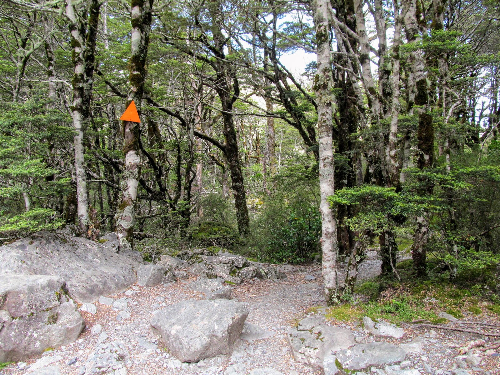
| Classic DOC orange triangle track marker in the Bealey Valley, Arthur's Pass NP |
Orange is the official DOC marking color and this is most commonly seen as orange triangles placed along the route of a track to show you the way to go. The triangles can be attached to anything really...trees, old downed logs, rocks, buildings, bridges..I have seen them on all of these.
In locations where there are no trees or other obvious bases to fix them to steel warratahs or fence supports are hammered into the ground and an orange sleeve is fixed over them. These are known as snow poles and can be seen in wide open valley flats, river beds and above the bushline across New Zealand.
 |
| A poled route marker on the track to Lake Emma Hut, Hakatere Conservation Area |
There are many other variations on this marking scheme so lets have a look at how tracks are marked in New Zealand.
Why mark tracks?
Tracks are marked for a number of reasons and people have been doing so for thousands of years. Ancient societies in Rome, Greece and China all had elaborate ways of marking their transport links and primitive societies have long used blazes on trees to mark paths through forest or jungle.
 |
| The Romans used milestones to mark their transport network |
The bush in New Zealand can be thick and difficult to travel through so over the years people have cut tracks to ease their passage through it. A cut track will very quickly return to its natural state (1-3 years on average...) when not in heavy use. People started marking their bush routes so they could find them after the bush had started to obscure the more obvious ground path.
 |
| Route finding in dense bush makes for slow, difficult travel... |
As New Zealand became a more civilised nation these ad-hoc marking methods were regulated and a number of standard marking options were used so people could easily follow tracks right across the country.
Track marking prior to the Department of Conservation (DOC):
Prior to 1987 there were a number of government departments and NGO's responsible for looking after backcountry areas in New Zealand. These included the Department of Internal Affairs, New Zealand Forest Service, Walkways Commission, Ministry of Defense and regional pest control boards.
 |
| Logo of the New Zealand Forest Service (NZFS) |
All of these groups marked backcountry tracks so it is worth looking at older systems of track marking as many of these markers are still in place.
Rock cairns:
One of the easiest and most well known track markers are piles of rocks called cairns. These have been in use for thousands of years around the globe as they are a quick, simple way of route marking that requires no supplies or special equipment. At a suitable spot on the route you just pile up some rocks to show others the way...
 |
| Classic rock cairn on the Travers Valley Track, Nelson Lakes NP |
One of the advantages of rock cairns is their longevity...rock does not deteriorate very quickly. There are remote places on the West Coast of the South Island where rock cairns built by early surveyors like Charlie Douglas and Julius Haast in the 1870's still exist. The downside is that they can be destroyed by floods, avalanches and rock slides while one rock pretty much looks the same as all the others.
 |
| A historic cairn built by explorer Charlie Douglas in the 1880's |
You are most likely to find rock cairns in high mountains and when crossing the bed of a river as supplies of stone for your cairn can be found in plenty. I often see cairns on the wide river flats of Canterbury and in places crossing mountain passes such as Fiordland and Nelson Lakes. Even the slight elevation offered by a pile of rock is visible for long distances in this type of terrain.
 |
| A cairn marking the track into the Upper Ahuriri River Valley |
 |
| Riverside cairns often mark fords in the river, creek or stream... |
A disturbing new fad is the building of rock cairns in scenic spots like beaches and river beds. I hate this...I see it as nothing but visual pollution and it breaks every tenet of the Leave No Trace practices. I have nothing against directional/navigational cairns but if I come across a field of cairns like those in the photo below I push them over and scatter the rocks.
 |
| Don't do this when you are tramping...visual pollution!!! |
Natural places are natural because humans have not impacted them to any degree..remember this the next time you are tempted to build some edifice to your everlasting self.
Tree blazes:
Tree blazes (slashes or cuts on the trunks of trees) are a widely used means of trail marking around the world and are especially well used in the United States. Some nations still use this as their primary track marking scheme although it has fallen out of favor as it damages the trees and makes them susceptible to disease and insect damage.
 |
| Classic tree blaze in the United States |
A variety of shapes and symbols can be transmitted using tree blazes and some locales have elaborate systems to pass the information to passing trampers. Here is a chart of common blaze symbols and their meaning as used by the US Forest Service in State and National Parks.
 |
| Chart showing the meaning of various blaze symbols |
Blazes were never well used in New Zealand although you still occasionally find them along old long established tracks like the Milford and they are also used by some of the private tracks and forestry parks around the country.
Wooden signs/posts:
Many of the older tracks and walkways around the country will be marked with carved wooden trail markers. These are a hold over from the days when the New Zealand Forest Service controlled many of these areas as this was one of their preferred marking methods. These are good markers...long lasting, simple to install and visible for some distance.
 |
| A wooden track sign, Arthur Range, Kahurangi National Park |
I have seen these kind of markers in a number of places around the country...Kahurangi National Park, Richmond Forest Park, the Tararua Ranges and on the central North Island in places like the Kaimaniwa's.
 |
| Wooden marker on the Holdsworth-Jumbo Track, Tararua Forest Park |
Originally most of these were painted white on brown but over the decades they have been repainted with the green/yellow scheme used by the Department of Conservation.
 |
| Wooden marker at Parkinson's Scenic Reserve, Kaituna Saddle, Banks Peninsula |
These wooden markers are gradually disappearing to be replaced by the virtually indestructible plastic and metal DOC signs...eventually they will only be a memory in the mind of olde timer trampers...
Metal track markers:
A variety of metal track markers have been used over the years and they tended to take the shape of discs in different colors and strip of permolat a reflective material used in venetian blind manufacturing.
Discs:
Both the Forest Service and the Department of Internal Affairs both used round stamped metal discs to mark their tracks. These came to be known as 'paint lid' markers as they resembled the lids used to seal tins of house paint. Incidentally metal paint tins were invented by a kiwi who licensed the patent and who's descendants are now fabulously wealthy as a result.
 |
| Classic metal paint tin... |
Paint lid markers were useful as they were relatively light weight so many of them could be carried at once and cheap and easy to manufacture. They were nailed to the trunks of standing and fallen trees, bolted to rocks and fence posts and buildings in much the same way orange triangles are now used.
 |
| Old style 'paint tin' track marker, Waimakiriri Flood Track, Arthur's Pass NP |
 |
| ...Waimakariri Flood Track: DOC triangle with permolat attached.... |
These markers were replaced over time with a new material called permolat.
Permolat:
In the late 1960's New Zealand developed an aluminium industry and one of the materials produced was a thin metal sheet used for Venetian blind making. Some bright spark decided it would make a good track marking material and so Permolat (the brand name) came to be the predominant marker material
 |
| White permolat track marker in the Sabine Valley, Nelson Lakes NP |
The usual color for permolat was a grey/white color which shows up well in most bush conditions in New Zealand. It was slightly reflective so would show up in a torch beam at night. Track makers would cut sections of permolat and attach it to the usual suspects...trees, posts, logs, buildings etc. The advantage of permolat was its light weight and ease of use...it could be cut with scissors and could be written on if required
The standard marker was a strip about 5-10 cm long cut at one end to denote track direction. I have also seen different sizes, crosses, squares, triangles and mixed colors..red on white, orange and red, orange and white etc.
 |
| Orange/white trial permolat marker... |
Trials were also undertaking using red and orange permolat as it was found the off white color did not stand out very well in some types of forest. White naturally occurs in nature while brilliant red and deep orange are uncommon. You will still see all colors of permolat along older tracks...in fact I struck some on the Lake Daniell Track just two weekends ago.
 |
| Orange permolat track marker, Lake Daniell Track, Lewis Pass Scenic Reserve |
Permolat was used from the late 1960's right up to the birth of the Department of Conservation but when that department was formed it was decided that a new and standardised track marking system was required.
Track marking under DOC:
The Department of Conservation was set up in 1987 with the idea of centralizing all of the various groups into one department with responsibility for all aspects of the outdoors. They absorbed many of the tasks, facilities and staff of other government departments especially the NZ Forest Service.
 |
| Standard Department of conservation track sign...St James Walkway |
 |
| ...you get the destination, walking time and distance... |
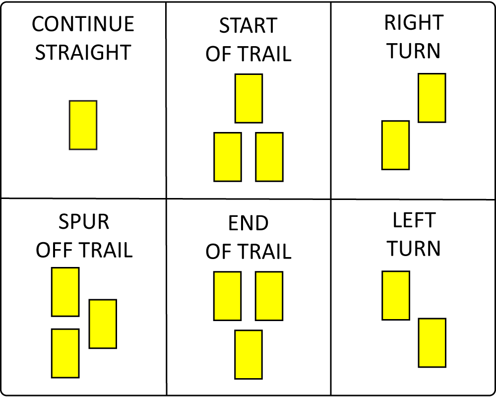
The official DOC marking system is orange plastic tags in a number of shapes and sizes to mark public track networks. These are usually an orange triangle with pre-drilled holes to make them easy to fix to trees, logs etc with nails. The apex of the triangle is used to denote direction; horizontal means straight ahead, angle to the left means go left, to the right go right etc.
 |
| DOC Orange triangle...visible in most bush types!! |
 |
| Orange track markers can be ground mounted is required... |
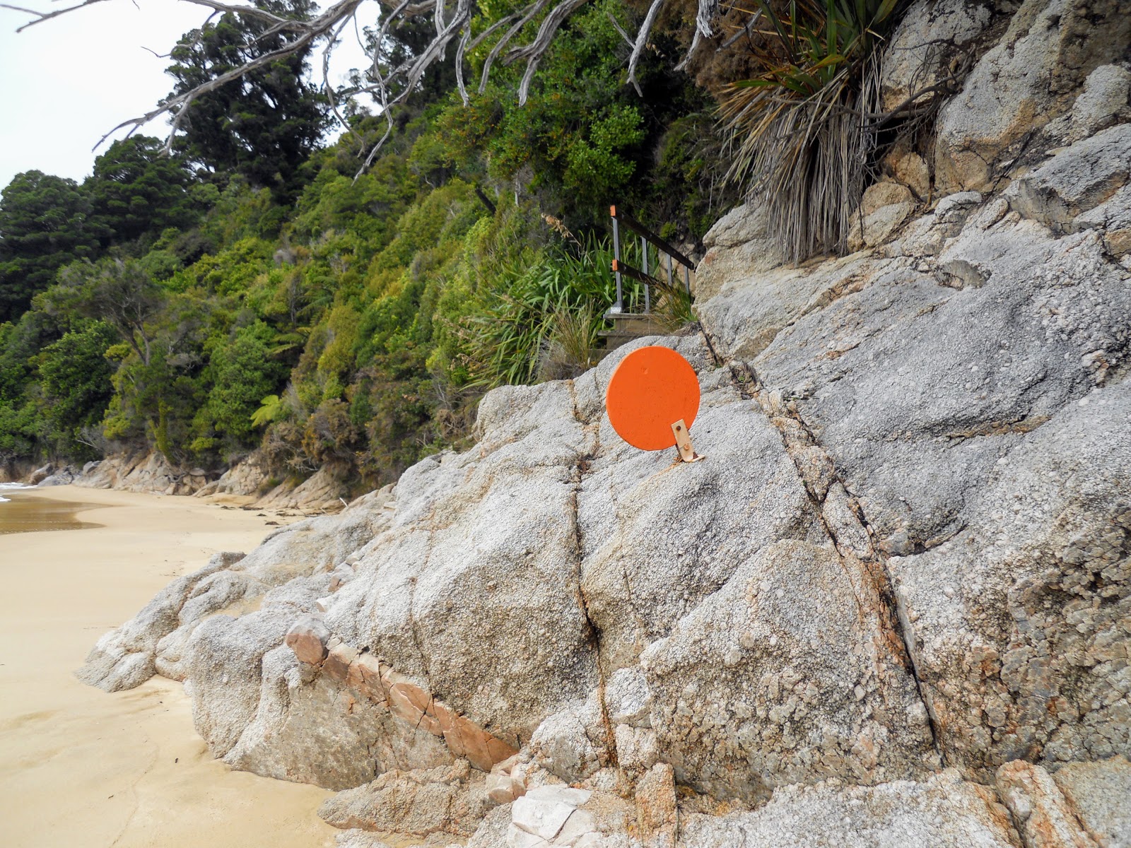
DOC track markers are not always triangles...I have seen squares, circles, strips and panels before as some types of terrain favor these shapes...
 |
| Not all DOC track markers are triangles... |
In areas where there is no vegetation to attach track markers snow poles are used. A snow pole is a metal fence strainer approximately a meter long which is hammered into the ground at regular intervals and a orange sleeve is fitted on the top to mark them clearly visible. They are called snow poles as they are often in places where snow may cover tracks in winter and they will often protrude out of the snow if it is not too deep.
Snow poles are most often found on flat grassy valley floors, riverbeds and mountain tops and are surprisingly effective as they are visible for a long distance. They will tend to be 20 meters apart but this is not a standard distance...I have seen them 3 meters apart in dense & tricky Matagouri country right out to 100 meters apart.
 |
| A snow pole on the Milford Track at McKinnon Pass |
 |
| ...snow poles are often found along the tops of ranges... |
A snow pole with a standard orange triangle attached denotes the point where the track is re entering the tree line so it is important to look out for these when heading down off the tops.
 |
| An orange triangle marks the descent into the forest below the tree line... |
 |
| Snow poles also work well in flat tussock valleys like these on the St James Walkway |
 |
| You should be able to see the next pole about 20 meters away... |
The standard orange DOC triangles and poles do not show up well in torch light at night as they tend to fade into the background. To aid travel in these situations they will often have strips of reflective material added to them so they are more visible. This works exceptionally well and I have seen it on markers right across the country.
 |
| Orange does not show well at night so.... |
 |
| ...reflective strip on a snow pole for night travel... |
You will sometimes see orange nylon flagging tape used to mark new or temporary tracks for example over active slips or where a track has been rerouted due to fallen trees etc. This is a temporary marking only and you should take care if following this type of marker so you do not get lost.
 |
| Orange tape will sometimes be used to mark temporary or new tracks... |
Department of Conservation markers are what you are going to encounter on a good 80% of the tracks you are walking so keep a close eye out for those orange triangles, circles, squares and snow poles.
Other agencies marking methods
The Department of Conservation is the main manager of backcountry areas but they are not the only agency which has this as a part of their work. There are many local, regional and private groups who also have wild tracks and need a marker scheme to show the route. Lets look a couple of these groups...
The Walkways Commission:
There was a short lived government led advocacy group called the Walkways Commission set up to promote the greater use of the outdoors within New Zealand in the 1970's till 1980's. They had a ton of great ideas but unfortunately they never had a large enough budget or paid staff to achieve very much.
 |
| Classic Walkways Commission sign for Waikakano Track.... |
 |
| The Summit Walkway was a CCC/Walkways Commission project... |
Some of their notable accomplishments are the St James Walkway, Summit Walkway and what would eventually become Te Ara Pataka here in Canterbury. They tended to build new tracks in previously un-tapped backcountry areas...a lot of their tracks were in virgin Forest Parks and unassigned land rather than National Parks.
 |
| The St James Walkway was one of their most successful tracks... |
 |
| Christopher Hut was built by the Walkways Commission... |
Any track you find yourself on which has 'Walkway' in the title would have been built or instigated under their tenure. Their work can be found from Northland all the way down to Bluff at the bottom of the South Island.
 |
| Old walkways track marker on the Orton Bradley-Mt Herbert Track, Banks Peninsula |
 |
| Walkways Commission post on Te Ara Pataka/Summit Walkway on Banks Peninsula |
The Walkways Commission used wooden posts with a yellow band painted around the top...they had a carved W on the top of the post as well. They also used carved wooden signs at huts, bridges and places of interest.
 |
| Another Walkways marker on the Orton Bradley-Mt Herbert Track, Banks Peninsula |
They had a square plastic tag similar to the DOC triangles with a prominent W in the middle these came in black and white and later white on orange.
 |
| Clear view of the Walkways markers on Te Ara Pataka track, Banks Peninsula |
The track and hut building work of the Walkways Commission was absorbed by DOC when it was set up in 1987 while the advocacy work of the defunct Commission is largely undertaken by the
NZ Walking Access Commission.
City Councils and Regional councils:
New Zealand towns and cities are a lot greener than their counterparts in other parts of the world. Most councils or regional councils will have a multitude of parks, reserves and wild areas within their boundaries and some of these are wild enough to warrant track markers. these bodies will often work with DOC as much council owned land will border Department of Conservation land.
 |
| Christchurch City Council track map at Travis Wetlands |
 |
| Typical CCC track marker in Travis Wetlands |
Here in Canterbury we have the Christchurch City Council and the Canterbury Regional Council both of whom manage wild areas around the city and on the Port Hills. They have a set of standardised track markers which you can see in the surrounding photos.
 |
| Council track marker in Bottle Lake Plantation |
 |
| Pedestrian only marker on the Harry Ell Track, Port Hills |
 |
| ...track name and destination but no distance or time... |
Here is a different take on a council track marking this is from the Kaikoura Clifftop Walkway in Kaikoura 10 km's to the north of Christchurch. This is a joint regional council/DOC/local Iwi initiative and as this locale has a rich Maori heritage the marker is denoted by the Koru design.
 |
| Basic track marker on the Kaikoura Clifftop Walkway |
Note on the Christchurch 360 Trail...
The
Christchurch 360 Trail is a 135 km long ring track that goes right around the outskirts of the city and takes in the beach, Bottle Lake Forest, the Waimakiriri River, the Port Hills and urban areas. It is made up of existing tracks which belong to a variety of landowners and can be completed as a run/walk/MTB ride or a combination of all three.
 |
| Map: Christchurch 360 Trail:Port Hills to Sumner section |
The Christchurch 360 Trail has its own trail marker...you are sure to have seen this marker if you enjoy the outdoors in Canterbury but perhaps you had no idea what it means. The colors and swirl are meant to encompass the idea that the trail is made up of different terrain types and encircles the city.
 |
| The Christchurch 360 Trail marker... |
Here are a couple of photos of sections of this track I have used over the years;
 |
| Christchurch 360 Trail: Travis Wetlands |
 |
| Christchurch 360 Trail: Godley Head, Port Hills |
 |
| Christchurch 360 Trail: an urban section in Parklands |
 |
| Christchurch 360 Trail: along the Christchurch Coastal Pathway in Redcliffs |
 |
| Christchurch 360 Trail: in Bottle Lake Forest Park |
I have only two sections of the Christchurch 360 Trail left to walk (Spencer Park to Brooklands & Godley Head to Taylors Mistake) and I will have completed the whole trail.
Private tracks:
Another type of track marking are those used on private tracks around the country. There are a number of tracks of this sort scattered around the country...while some use the standard DOC marking scheme some have developed their own designs using wooden signs, marker poles and track markers.
 |
| Track sign on the Kaikoura Coast Track |
A good example of this is the Rod Donald Track on Te Ara Pataka the DOC track from Hilltop Tavern to Gebbies Pass via Mt Herbert on Banks Peninsula. The Rod Donald Trust own and operate Rod Donald Hut and have built a side track from the main track to the hut. The Rod Donald Track is marked with their own version of the DOC green/yellow sign and has wooden track marker poles along its course.
 |
| Private walkways often have wooden signs...Rod Donald Track |
 |
| More wooden trail marking on the Rod Donald Hut Track |
Another local example is Orton Bradley Estate on the southern side of Lytellton Harbor. The trust have developed a series of excellent tracks on this land and have their own markers in place to show the route. In this case they use wooden signs in brown and white and wooden track poles painted blue at the top. They also use snow poles with a yellow sleeve on top to show they are tracks but not DOC tracks.
 |
| Wood track signs at the Orton Bradley Estate, Banks Peninsula |
 |
| Yellow snow poles at Orton Bradley Estate, Banks Peninsula |
Note the blue post marker in the forefront of the photo below but also the yellow/blue track marking on the fence as it heads further up the hill. you will often see multiple marking systems used along a track as multiple organisations have responsibility for that track.
 |
| Blue track marking along trail at Orton-Bradley Estate, Banks Peninsula |
Yet another example is the Queen Charlotte Track (QCT) in the Marlborough Sounds...they use a combination of standard DOC markers and white posts with blue QCT markers attached to the tops.
 |
| White posts with blue track signs on the Queen Charlotte Track, Marlborough |
 |
| Queen Charlotte Track, Marlborough: the track has distance markers... |
 |
| Standard DOC track marking on the QCT... |
They also use markers to denote the distance left to the end of the track and the entrance to private tracks & lodges (which are a feature of this walkway) and who have their own style of track marking as well.
 |
| QCT location marker for Shamrock Ridge |
 |
| Track marker to Madsens Camp, one of the private lodges on the QCT |
The QCT is probably the most successful of the many private tracks scattered around New Zealand an it is well used especially over the summer period from late September right through to April by both MTB riders and walkers. It is highly likely it will eventually become a Great Walk as it has been considered for that category several times now.
Here is a series of other private tracks and samples of their track markers...
 |
| Old Ghost Road on the West Coast , South Island |
 |
| The Humpridge Track, Southland |
 |
| Banks Track, Banks Peninsula, Canterbury |
 |
| On Four Peaks Track, South Canterbury |
As you can see similar methods are used to mark all of these varied tracks.
The Te Araroa Trail (TA):
The
Te Araroa Trail was set up in 2010 as a long distance trail from Cape Reinga in the north to Bluff in the South and is based on the long trails like the Appalachian Trail. PCT and Camino de Santiago. The TA has its own logo and its own style of track marker based on this logo.
 |
| The Te Araroa Trail logo.... |
The Trust has its own style of information panel as seen in the photo below...they look different to DOC signs and have different types of information on them. You will only see these on sections of track developed by the Te Araraoa Trail Trust.
 |
| Te Araroa Trail information panel near Huntley, Waikato |
Most of the tracks incorporated in the TA are existent DOC tracks strung together but their are some TA specific sections built by and maintained by the Te Araroa Trust.What you will usually see is a TA marker added to existing DOC trail markers, signs and information panels. Here are a couple of examples I have struck while out tramping...
 |
| The Te Araroa Trust also use DOC orange triangles... |
 |
| Te Araroa Trail logo added to standard DOC signs... |
There are also DOC signs which are specific to the Te Araroa Trail such as this example at Stirling Point which is the southern terminus of the whole Te Araroa Trail. This sign would not exist if not for the TA...
 |
| Specific Te Araroa Trail sign on a DOC track at Stirling Point, Bluff |
Keep an eye out for signs of the Te Araroa Trail when you are tramping as they are more common than you might expect.
Private forestry tracks:
Another place you will find track signs and markers are in forestry areas which allow public access...usually near holiday destinations. A good example is the privately owned Hanmer Forest Park in North Canterbury. This is a working forestry area with historic sections of forest criss-crossed with good walking trails from 20 minutes right up to 4 hours.
 |
| Matariki forestry sign at Hanmer forest |
The forest is owned by Matariki a subsidiary of the local Maori tribe Ngai Tahu. The Iwi own several parks of this type in Canterbury including Hanmer Forest Park, Bottle Lake Plantation and Balmoral Forest. All of these have tracks the public are allowed to use.
 |
| The Hanmer Forest signs have their own color palate... |
Forest parks often used the standard DOC track marking system but in the case of Hanmer Forest Matariki have trail signs and markers to their own design. This park uses tree blazes to mark some sections of track and orange and white wooden posts on others.
 |
| Hanmer Forest Trails are also marked with red/white poles... |
Bottle Lake Forest Park is a working forest on the northern outskirts of Christchurch owned by Matariki Forestry and the Christchurch City Council. It has a warren of tracks for walking, running, MTB riding and horse trekking and is well known and beloved by the people of Canterbury. They use their own signage and track markers through the forest....
 |
| Map showing track network in Bottle Lake Forest Park... |
They use white plastic trail markers in the forest park with the standard council track signs...a walking/running person, a MTB bike of a horse to denote track type. They also have wooden track signs and larger information panels showing the whole track network.
 |
| Bottle Lake Forest Park: track sign and white plastic markers... |
This is one of my favorite haunts and I am often out here either riding my bike or walking through the forest. One of my fitness walks is to use the Pegasus Walkway track to walk from Waimairi Beach to Spencer Park and back.
Pest control tracks:
It is worth mentioning one other type of track marking you are going to see in the bush..that is pest control line markers. New Zealand is over run with a variety of introduced pest species; rabbits, mice, rats, cats, stouts and possums are just a few of the worst pest species. Because they are introduced they have no predators which means numbers quickly get out of hand.
 |
| Possums are a major pest species in New Zealand |
Every backcountry area in New Zealand will have an ongoing pest control plan which will include poison air drops, trap lines and in some cases contract shooters. These pest lines are usually marked by different colored triangles (red/blue/white/pink/yellow) and or colored nylon tape to show the route of the trap line. These type of tracks are used by DOC, NGO's and private groups.
 |
| A yellow track marker for trap lines... |
You should never follow any of these markers when you are out in the bush as they usually head into the roughest, most dense bush you can imagine.
 |
| Pink triangle indicates a trap line at Lake Rotoiti, Nelson Lakes NP |
 |
| The pink triangles lead to a bait station off the track... |
These different marker colors are also used for other tasks such as marking tracks to bio diversity sites, new un-completed tracks or as a route to a DOC staff hut.
 |
| Different color track markers sometimes denote biodiversity huts... |
These tracks are made by people who spend a lot of time in the outdoors and who have good bush navigation skills. Trying to follow one of their poorly marked tracks is probably a damn fine way of getting yourself irretrievably lost!
 |
| Georgia checking a DOC trap at Parkinson's Scenic Reserve, Kaituna Pass, Banks Peninsula |
So there is a short potted history of track marking in New Zealand...Im sure I have forgotten to mention something but I will add it to the post if it occurs to me. Have a look at the track marking along the next track you happen to be walking along and see how effective they are in keeping you on the right course.
Follow the orange markers folks.....