From Anchorage to Marahau in the rain...
As I was saying in my last post...I managed to get onto an early watertaxi from Totaranui to Anchorage so instead of arriving at around 5 pm I was going to be on the beach and ready for lunch by 1.20 pm.
 |
| On the watertaxi heading away from Totaranui |
It was a bit rough on the watertaxi trip as the swell from the approaching storm had started to come in but it was crystal clear overhead. I could see Mt Taranaki way off to the horizon as we made our way up the coast. It was low tide when we arrived at Anchorage so I got wet boats as I had to wade ashore from the boat. It was good to be finished walking for the day...
 |
| Anchorage Beach, Abel Tasman NP |
There were hardly any people at anchorage which was very surprising but as the day progressed more and more day walkers arrived. Most of them were gone by 3 pm as multiple watertaxi's came to uplift people and take them back to Marahau and Kaiteriteri.
 |
| View west along Anchorage Beach, Abel Tasman NP |
 |
| Anchorage is surrounded by hills on three sides... |
 |
| Looking towards Pitt Head from Anchorage |
I headed up to the hut to get myself a bed...I was the first overnight visitor to arrive and by the end of the day we had about 25 people at the hut. The largest group was a couple of families who had just come for one night with a support boat carrying all their gear like some 19th Century imperial expedition to the Sudan to fight the Fuzzy Wuzzies...
Good idea though....
 |
| DOC sign next to Anchorage Hut |
 |
| Carved Maori warrior at Anchorage Hut |
Anchorage Hut is very nice but I also dislike the set up of the bunkrooms...they are eight bunk cells which is fine if every group is eight people strong but means you end up sharing with other people. I don't mind this but it does make it a bit awkward as you feel like you are imposing on them. If it is one big bunkroom there is more anonymity.
After dinner when everyone went to bed I went and grabbed my gear and slept under the table in the main living space. I had to sleep under the table because the solar lights work on a sensor and if you are out in the open they keep coming on all night..as I discovered!!!
 |
| Bunkrooms at Anchorage Hut, Abel Tasman NP |
It was calm and warm when I arrived but it got winder as the day progressed...I sat down on the beach for about an hour reading my Kindle before it start to get chilly. There were a lot of people waiting for their watertaxi and a small group of people camping at Anchorage were out swimming in the bay.
 |
| The wind picked up in the afternoon at Anchorage |
 |
| People waiting to board the watertaxi at Anchorage |
I passed a decent night at Anchorage and it was warm and cosy in the hut that night. I chomped my way through most of my remaining food so I didn't have to carry it the next day. I just left my lunch, snacks and some chocolate for the trip out.
Anchorage to Marahau in the rain...
Rain was due on the Sunday and sure enough about 4 am it started to absolutely piss down. It meant I would have a wet and windy walk out but I have the gear to allow this so it was no big concern to me. I didn't envy the various groups due to leave by boat as it was super rough in the Anchorage so it must have been stomach churning out to sea...
 |
| Setting out for Marahau on the Sunday... |
I was packed and ready to go by 7.30 am and I set out down to the beach to start my four hour trip out to the road end. It was lightly raining and windy but I was comfortable in my wet weather gear and so I just put my head down and started covering the kilometers...
 |
| Wind, rain and misty cloud over the Anchorage |
 |
| A small boat loading at Anchorage Beach..bugger that trip!!! |
The track heads off the beach about 300 meters from the hut and at first you are on a track running along the back of the beach. This turns and starts heading uphill along the Anchorage Access Track and you will be walking uphill for the next hour to get to the main track.
 |
| The Abel Tasman Coastal Track heads inland... |
It was more sheltered under the trees and while I was getting wet from the rain falling off the foliage the trees did protect me from the worst of the wind blowing off the ocean.
 |
| On the first section of the track behind Anchorage Beach |
 |
| Starting the climb up the Anchorage Access Track |
I takes about an hour to slog up to the main Abel Tasman Coastal Track and the best way to handle the climb is to just go slow and grind it out. It is steep to the lookout to Te Pukatea Bay but after that it levels out a lot...
 |
| Anchorage Access Track heads to the low point on the ridge... |
 |
| On the Anchorage Access Track..... |
The view inland was not good...the inland mountains were covered in thick cloud and you could see bands of rain falling. The wind grew in intensity as you got higher up the ridge and when you break out into the clay balds on the top of the ridge it was really howling...
 |
| View inland from the Anchorage Access Track, Abel Tasman NP |
 |
| ...top of the steepest section on the Anchorage Access Track... |
There is a great view down to Torrent Bay from near the lookout and it was looking dark and foreboding on this day...
 |
| View to Torrent Bay from the Anchorage Access Track |
I didn't a lot spend time looking at the scenery as I just wanted to get further up the ridge and into the cover of the bush. From the lookout to the junction with the Coastal Track you are in thick bush so most of the wind just shoots over your head...
 |
| It was windy and raining on the Access Track route |
 |
| Junction of Anchorage Access Track and Abel Tasman Coastal Track |
One of the groups from the previous night and I reached the main track at the same time and we kept leap frogging each other from here to near Apple Tree Bay before they motored off in the distance. They were the party using the boat top carry their gear and the walking party consisted of two women and about five kids. The rest of them were making the super rough trip in their boat...
 |
| Heading for Marahau on the Abel Tasman Coastal Track |
I didn't see any other trampers until I got past Tinline Stream as no fools were keen on walking into a backcountry hut in a big storm. I imagine Anchorage would have been very quiet that night as no watertaxis were running that day either...
 |
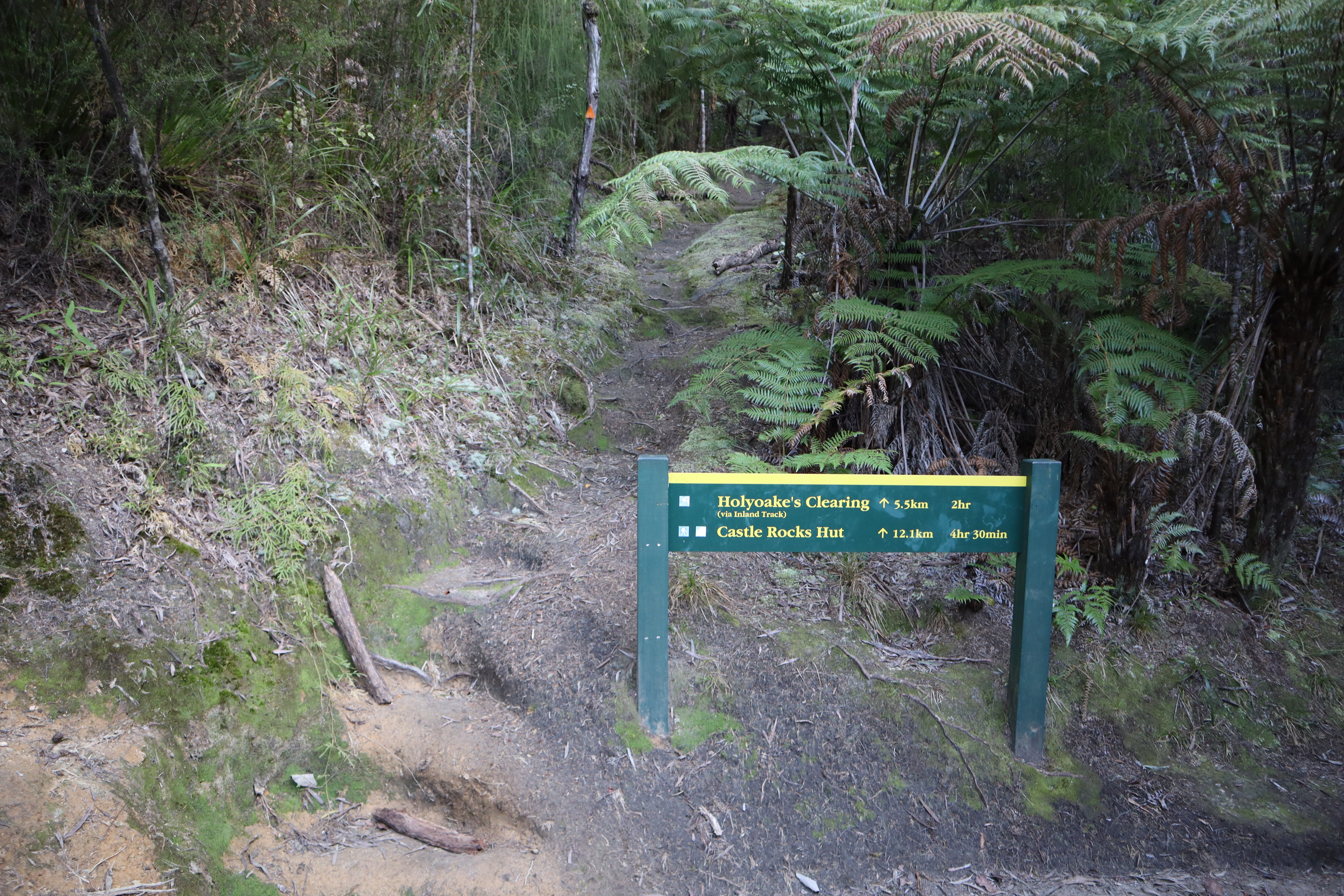
| Junction of Abel Tasman Coastal Track and Holyoake Clearing Track |
Just past the track to Holyoake Clearing you cross the first of the 31 bridges you go over on your way to Marahau. It was much nicer walking in the forest as it was all downhill and you were protected from the worst of the wind and rain by the trees.
 |
| First of 31 bridges between Anchorage and Marahau |
 |
| The Abel Tasman Coastal Track is benched clay and rock... |
 |
| Palm like ferns above Cyathea Cove, Abel Tasman Coastal Track |
I stopped at the track junction for Observation Beach for a drink and snack break but didn't stop again until Yellow Point Track as it was just too wet to contemplate and I wanted to get to the carpark. Normally I stop every 30 minutes for a couple of minutes and I was feeling a bit tired by the time I got down near Tinline campsite
 |
| Turn off to Observation Beach...Abel Tasman Coastal Track |
 |
| On the Abel Tasman Coastal Track heading for Akersten Bay |
You could just make out Adele Island off shore as there was so much rain falling in the Astrolabe Roadstead...it kept coming in and out of view in breaks in the clouds.
 |
| Adele Island just visible in the misty rain... |
 |
| Track cutting on the Abel Tasman Coastal Track |
 |
| Stillwell Bay just visible from the Abel Tasman Coastal Track |
There were a couple of larger sail boats anchored in the lee of Adele Island (it is one of the better anchorages in the area) but it must have been choppy out there...
 |
| The eastern end of Adele Island and the Astrolabe Roadstead |
 |
| Abel Tasman Coastal Track close to Yellow Point |
The party from the hut hared off down the Yellow Point Lookout track but I just kept walking as I went down there the last time I here in 2020. There would not be much to see with the low cloud and rain but good on them for the effort. The junction with Yellow Point is just under half way between Anchorage and Marahau so I was on the last two hours of my trip...
 |
| Turn off to Yellow Point and Akersten Bay, Abel Tasman NP |
 |
| Yellow Point is half way to Marahau...Abel Tasman Coastal Track |
 |
| Grove of Rimu trees high above Akersten Bay |
Before I knew it Stillwell Bay came into view and even with the rain I could still see how attractive it is. Stillwell is actually a private beach but the owners allow the public to come down and visit it. There is a very nice looking hut located there with a boat ramp and dock. Sea kayakers often stop here on their way along the coast and the last time I was here people were laying on the sandy beach...
 |
| Stillwell Bay comes into view...Abel Tasman Coastal Track |
 |
| There is one private hut at Stillwell Bay, Abel Tasman NP |
With all the rain the streams, creeks and waterfalls were all running...there were many small waterfalls running down the hillsides and across the track. Most of them are usually dry as the water quickly runs off this rocky clay soil...
 |
| On the approach to Lesson Creek, Abel Tasman NP |
 |
| Lesson Creek Bridge, Abel Tasman NP |
 |
| ...you can take drinking water from Lesson Creek... |
I stopped just past the turn off to Stillwell Bay under some trees for a drink and a snack as I had been on the go for 2.5 hours by that stage. It is 7 kilometers or two hours walk from Stillwell Bay to the DOC carpark at Marahau...
 |
| Turn off down to Stillwell Bay from Abel Tasman Coastal Track |
 |
| Adele Island disappears into the rain clouds... |
 |
| ...the wind was strong along the Abel Tasman Coastal Track... |
It started raining harder past Stillwell Bay and I was a little more exposed along the track as the forest is thin. I was ok in my jacket but I had decided to leave my wet weather pants at home and while I didn't get cold they would have stopped my shorts getting wet.
 |
| Cascade flowing down past the Abel Tasman Coastal Track |
I'm thinking about investing in a rain kilt as I find rain pants too constricting when walking. They are expensive as they only sell them overseas and they are made of Cuben Fibre. I have made kilts from a plastic bag and tape in the past and they do work but a commercial version might be better.
I will do some research about retailers...
 |
| Descending towards Apple Tree Bay, Abel Tasman Coastal Track |
As you can see it was wet..it was warm rain falling so I didn't get cold but yeah I was soaked. I have always enjoyed walking in the rain even in my Army days. It is O.K provided you have a positive attitude towards it.
As they say there is no bad weather just bad gear...
 |
| Jon was wet but having a good time... |
I just managed to see Fisherman Island off the coast when I walked past it...the cloud had lowered almost to sea level and it was teeming with rain out to sea.
 |
| Fisherman Island off Apple Tree Bay, Tasman Bay |
 |
| Protective fence above the Astrolabe Roadstead |
Before I knew it I was walking past the turn off to Apple Tree Bay and the ocean side campsite. Apple Tree Bay is a nice looking campsite located on a spit of land with a small lagoon behind it. It has a number of large trees for shade, toilets and fresh water from nearby Simonet Creek.
 |
| Turn off to Apple Tree Bay from the Abel Tasman Coastal Track |
 |
| The Apple Tree Bay campsite from Abel Tasman Coastal Track |
Just along the track from Apple Tree Bay is Simonet Creek which is the other permanent water source along the track. There is access down to the river from the track. You can take water from the creek but do filter or treat it before use. I usually stop here for a break on my way to Marahau but it was just too wet so I carried on...
 |
| Heading down towards Simonet Creek, Abel Tasman NP |
 |
| Simonet Creek Bridge, Abel Tasman Coastal Track |
 |
| Looking at Simonet Creek, Abel Tasman Coastal Track |
Just past Simonet Creek the heavens opened and it start to bucket down with rain...this was in keeping with the forecast which had heavy rain falling after 10 am. It was so wet that I had to stop filming and I took my camera off my hip belt and stashed it inside my pack. I didn't take any photos or vlog clips from here to just past Tinline Stream.
Here are some photos from 2020 to show you what I passed...
 |
| Coquille Bay from the Abel Tasman Coastal Track (2020) |
 |
| Fisherman Island from the Abel Tasman Coastal Track (2020) |
 |
| Track to Holyoake Clearing near Tinline Campsite (2020) |
 |
| Tinline Campsite, Abel Tasman Coastal Track (2020) |
 |
| Tinline Stream Bridge, Abel Tasman Coastal Track (2020) |
 |
| Sandy Bay and Marahau from the Abel Tasman Coastal Track (2020) |
The rain eased off slightly as I approached the causeway over Marahau estuary so I hauled the camera out to cover the end of the trip. It was still teeming with rain but I hid my camera down the front of my jacket to keep it dry and continued on my way.
 |
| On the track between Tinline Bay and Marahau |
There is a new carved Maori warrior at the start of the Abel Tasman Coastal Track...it has been installed sometime since October last year. There are now guardian figures at Wainui, Totaranui, Medlands Beach, Anchorage and Marahau. They could do with an interpretive panel explaining why they are there...
 |
| New carving at the start of the Marahau Causeway |
 |
| DOC sign at the Marahau end of Abel Tasman Coastal Track |
The last 600 meters of the track are across the Marahau Causeway and it has been substantially improved over the years as it kept being damaged in big storms. Heavy rain in the surrounding hills floods the Marahau River and the flow will easily top the bridges. Not a problem when I crossed over as it was low tide and the rain had just started that day.
 |
| On the Marahau Causeway...nearly finished!!! |
 |
| Last bridge along the Marahau Causeway, Abel Tasman Coastal Track |
There is a portal at the official end of the Abel Tasman coastal Track similar to the one at Wainui. There are carved portals on several of the Great Walks now including the Heaphy Track, Paparoa Track and Rakuira Track. This one is interesting in that it is facing the track end almost like it is welcoming you back into civilisation...
 |
| The carved portal at Marahau at the end of the track |
 |
| Final 50 meters to Abel Tasman Coastal Track carpark |
I stopped at the bus shelter to organise myself as it was raining very heavily and there is no shelter down at the Aquataxi carpark to find gear in your pack. I needed my keys near the top so I could quickly chuck my gear in the car when I got there.
The wind was whistling and howling down the valley and I was even getting hit by rain under the bus shelter. Looking out across the valley you could see horizontal rain falling and the roadside and pathways from here down to the car were all flooded. I had to walk down the middle of the road to avoid all the puddles.
 |
| ...taking cover at the Marahau bus shelter... |
That was the end of my three day adventure in Abel Tasman National Park with two beautiful sunny days and that last wet & windy day. I have now covered the full length of the Coastal Track on the blog and it only remains for me to do a trip to Harwoods Hole and Canaan Downs and I have covered most of the park. There is great tramping in Abel Tasman and I think my trip for 2022 (if there is one..) will have to be a camping expedition staying at the beach side campsites.
I cannot wait....
Access: From Marahau walk north to Anchorage on the Abel Tasman Coastal Track. Alternatively take a watertaxi to Anchorage and walk back out to Marahau.
Track Times: 12.5 km's or 4 hours from Anchorage to Marahau on the Coastal Track.
Hut Details: Anchorage Hut: Great Walk, 34 bunks, wood burner, filtered water tank, wood shed, flush toilets; DOC campsites at Te Pukatea Bay, Watering Cove, Observation Beach, Akersten Bay, Apple Tree Bay, Coquille Beach and Tinline campsite
Miscellaneous: All huts on the Abel Tasman Coastal Walk are on the DOC Great Walk booking system and must be booked for overnight visit. Hut Warden in residence from late November to 30th April each year. Campsites are located at most bays and must also be booked year round.