Waipapa Point Reserve...of lighthouses and ship wrecks...
On day five of our trip down to the Catlin's we started with a trip south down to Waipapa Point. This was the furthest south we went on this trip and our destination was the scenic reserve and lighthouse there. Waipapa Point is about 40 minutes drive south of Curio Bay and is the last significant point before leaving the Catlin's.
 |
| At the Waipapa Point Scenic Reserve in Southland |
Waipapa Point was the place the SS Tararua (a coastal steamer) wrecked in 1881 with the loss of 131 people. It remains to this day the worst maritime disaster in New Zealand waters. The great loss of live was the impetuous for the construction of a new lighthouse here to mark a series of reefs along this coast.
 |
| Waipapa Point Lighthouse with Rakuira in the distance |
There is still a working lighthouse here although it is now unmanned as the reefs still pose a navigation danger to ships heading into Foveaux Strait, Invercargill and Bluff.
 |
| Waipapa Point Lighthouse |
So...lets have a look at what you can expect if you ever head this far south.
At Waipapa Point Lighthouse:
Waipapa Point is in the southern end of the Catlins area and close to the town of Fortrose. There is a Scenic Reserve here, the lighthouse and several rocky reefs jutting out into the surround ocean. The track to the lighthouse starts and finishes at the Waipapa Point carpark at the end of Waipapa Lighthouse Road.
 |
| Waipapa Point Lighthouse from the carpark |
 |
| On the Waipapa Point Lighthouse track |
You head along the track with the lighthouse clearly visible right from the start as this area is flat barren pasture with a minimum of trees. The first point of interest is the site of the old Lighthouse Keepers cottage. Prior to automation in the 1980's there was a resident lighthouse keeper and they were provided with accommodation right next to the lighthouse.
 |
| Side track to the old lighthouse keepers cottage, Waipapa Point Scenic Reserve |
Lighthouse keeping was a harsh lonely job so the keepers were allowed to bring their families with them. Lighthouses of the time worked with oil so they required frequent maintenance to keep them in working order. Someone had to be here at all times incase of darkness, sea fog or stormy weather when the light would need to be lit and kept running.
 |
| Information about living at Waipapa Point |
Unfortunately the cottage here burnt down in the 1990's so that all that is left is the foundation of the house and the stand of Macrocarpa trees that once enclosed the cottage grounds. There is an information panel here which describes what was here and why.
 |
| Trees at keepers cottage site...Waipapa Point Scenic Reserve |
Continuing along the track you can see the Waipapa Lighthouse about 400 meters away and the track takes you over and around a series of old sandhills to the side of the lighthouse itself.
 |
| On the track to the lighthouse, Waipapa Point Scenic Reserve |
 |
| ...the track is an old gravel access road, Waipapa Point Lighthouse... |
 |
| Waipapa Point Lighthouse, Southland |
Waipapa Lighthouse was completed in 1882 after a massive outcry over the loss of life in the SS Tararua disaster. The locals had been asking for a lighthouse here for nearly 20 years prior to the sinking and as was the way of the times nothing was done until something dramatic happened...
 |
| ...the Waipapa Point Lighthouse is on a small hill... |
 |
| Waipapa Point Lighthouse...similar to Nugget Point Lighthouse |
 |
| Information about Waipapa Point Lighthouse |
The Lighthouse sits on a slightly raised sandhill with clear views out to the ocean around Foveaux Strait and the light can be seen from as far away as Invercargill, Bluff and even on Rakuira across the strait. The lighthouse was constructed from Kauri and Tawa wood which is why it is still in such excellent condition and it was recently restored and painted so it can continue to operate for some years to come.
 |
| Paving in front of Waipapa Point Lighthouse |
There are some awesome views from the lighthouse and you can clearly see Invercargill, Bluff and the surrounding coastline from the site. This is also the eastern entrance to Foveaux Strait which separates Rakuira/Stewart Island from the South Island.
 |
| View out to sea from Waipapa Point Lighthouse |
 |
| View west towards Bluff from Waipapa Point Lighthouse |
On a clear day you can clearly see Rakuira/Stewart Island in the distance...it is about 30 kilometers away due south of the Point. We could clearly see Rakuira from the Point especially as a thunderstorm was building over the hills in the center of the islands. Looking west you can also see the Titi Islands which dot the strait over on their western side.
 |
| Rakuira/Stewart Island from Waipapa Point Lighthouse |
 |
| Foveaux Strait and Titi Islands from Waipapa Point Lighthouse |
There are reefs on both the eastern and western side of Waipapa Point which are visible from its base and to the west a long curved sandy beach heads all the way around to distant Bluff.
 |
| Reef to west of Waipapa Point Lighthouse |
 |
| Foveaux Strait and Titi Islands from Waipapa Point Lighthouse |
 |
| Oceanside view of Waipapa Point Lighthouse |
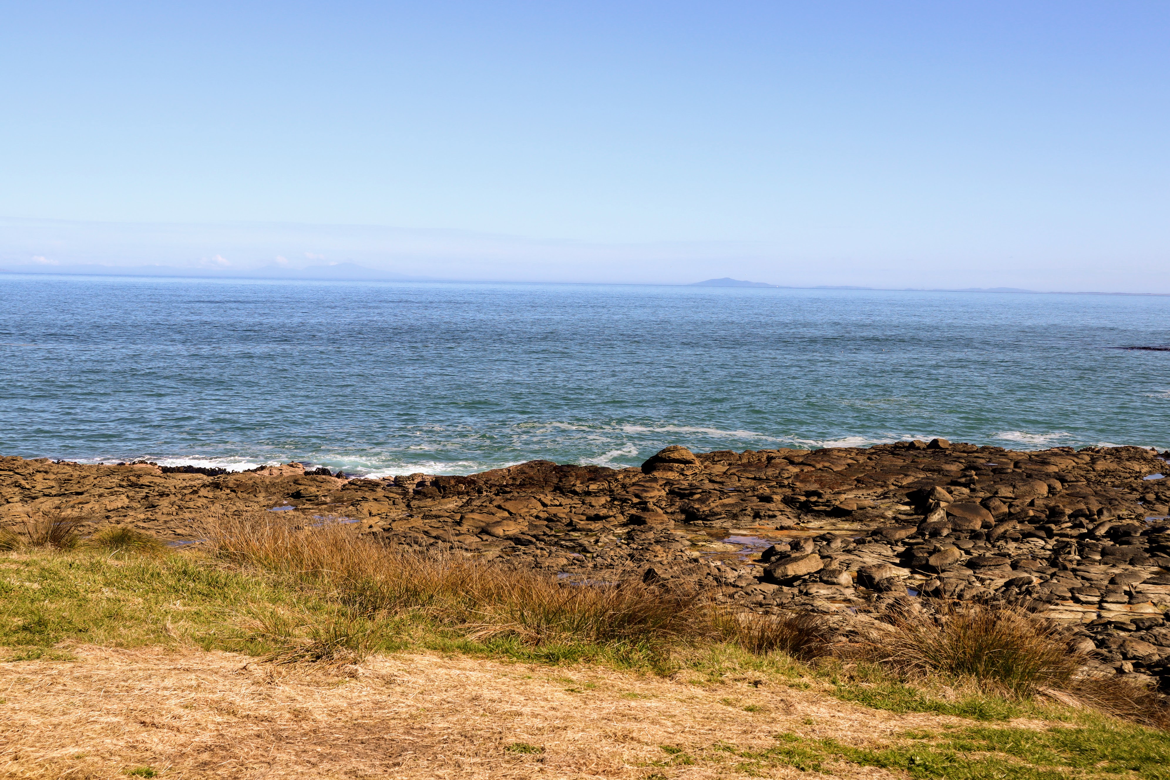
After ten minutes enjoying the view from the lighthouse we headed out onto the reef to the east of the point and had a look at the inlets and tidal pools which cover this reef. It is a flat area of mudstone which is slowly being eroded by the ocean. It really reminded me of the rocky coastline you get up near Kaikoura and other spots along the eastern cost of the South Island.
 |
| Reef to south of Waipapa Point Lighthouse |
We could see clouds out over Rakuira as a storm was due to arrive later that afternoon and these helped to highlight the extent of the landmass on that island chain.
 |
| Clouds gather over Rakuira/Stewart Island |
 |
| Looking north from near Waipapa Point Lighthouse |
While exploring the rocks we came across several petrified trees emerging from the base mudstone. This coast once boasted an extensive coastal podocarp forest and these fossils are the remains of some long ago coastal swamp. Fossils like this can be found right along the coast from here up to Curio Bay.
 |
| Fossilized tree at the Waipapa Point rocks |
There is a small sandy beach between Waipapa Point ant Otara Reef which is where the SS Tararua sank. You can walk over to and along the beach and at certain times of the year you will find Fur Seals and Sea Lions resident on the beach. There were none here at the time we visited but we did se the odd one on the rocks as we drove along the coast.
 |
| There is a sandy beach in front of Waipapa Point Lighthouse |
 |
| View north from in front of Waipapa Point Lighthouse |
There were a few people at Waipapa Point...certainly the most we saw the whole time we were down in the Catlins. It would be about 40 kilometers from Invercargill and I would imagine it would be a popular weekend drive for people living there.
 |
| People out exploring the reef at Waipapa Point Lighthouse |
There is a nice view of the lighthouse from down on the beach and you can really see how even the couple of extra meters of elevation the sandhills create helps the lighthouse do its job.
 |
| Waipapa Point Lighthouse is visible from four sides |
From the beach we followed the track back towards the carpark...there is a short loop of track which goes closer to the coast so we followed this for the views out to the ocean...
 |
| Heading back to the carpark from the Waipapa Point Lighthouse |
 |
| The hill at Waipapa Point is about 40 meters asl |
You can see the reef the SS Tararua hit in the photo below...Otara Ref is just to the north of Waipapa Point and submerged at high tide. The ship took nearly 20 hours to sink but unfortunately a heavy storm at the time made rescue impossible. I will discuss the Tararua disaster in more detail below...
 |
| Otara Reef the SS Tararua hit in 1881, Waipapa Point |
We left the lighthouse behind after one last fleeting look and made our way back towards the carpark.
 |
| Passing by Waipapa Point Lighthouse |
 |
| On the track from Waipapa Point Lighthouse |
You can see how quickly the storm over Rakuira was building from the clouds in the photo below. By the late afternoon it was raining along this coast but by then we were safely ensconced in the amenity block back at Curio Bay tucking into our dinner.
 |
| ...A big storm was gathering over Rakuira... |
 |
| View along the beach at Waipapa Point |
There are a couple of information panels dealing with the SS Tararua disaster up near the carpark and Karen and I took some time to go over and have a look at them. This is the closest spot to where the ship actually sank and you can see the reef just off the coast and stretching out to sea to ensnare any unwary coastal shipping.
 |
| Site of 1881 wreck of SS Tararua, Waipapa Point |
 |
| Information panel detailing SS Tararua wreck |
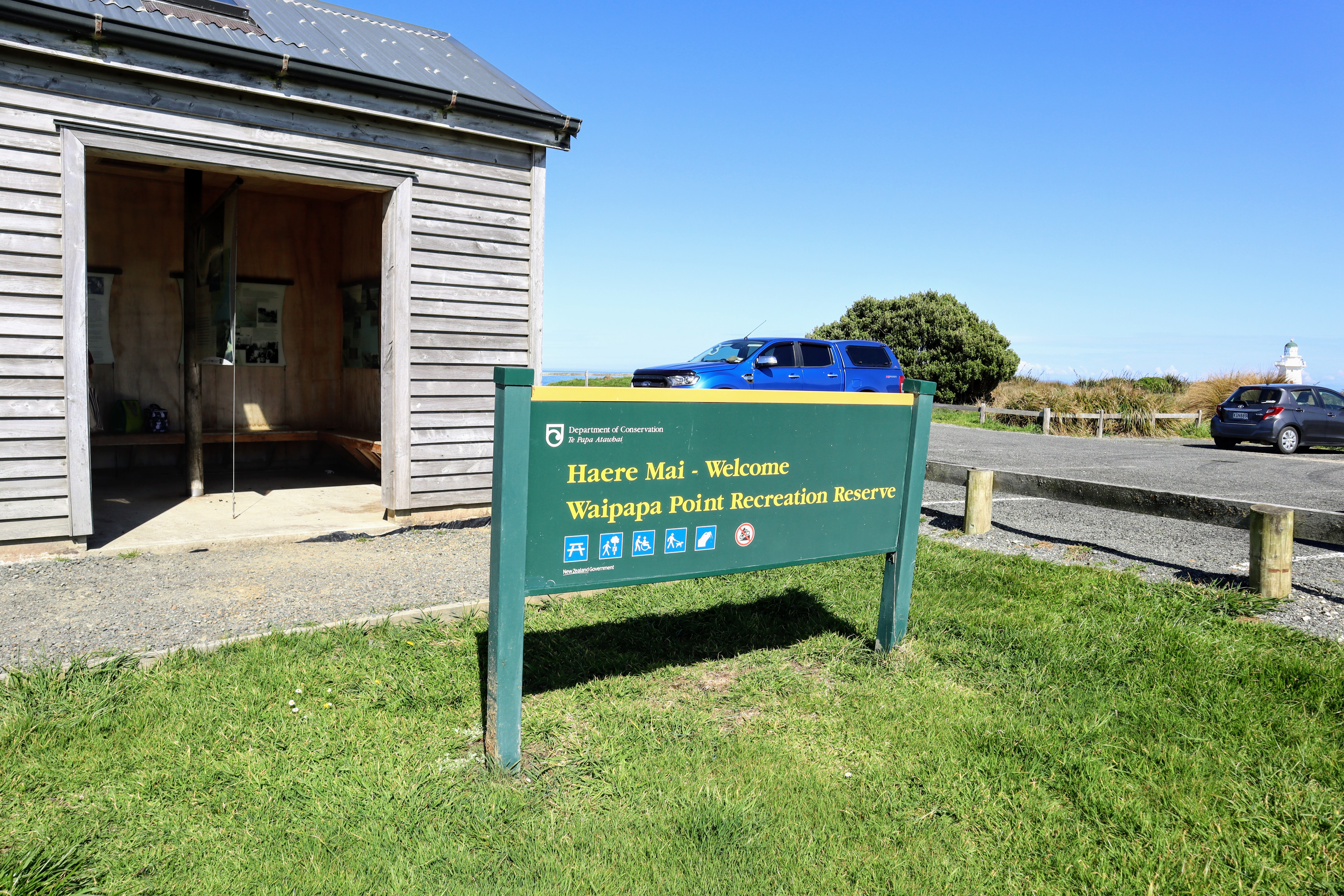
There is an excellent shelter and amenity block located next to the carpark. It would be an awesome spot to stop for a picnic before heading to other points.
 |
| Waipapa Point Shelter, Waipapa Point Recreation Reserve |
 |
| DOC sign at the Waipapa Point Shelter, |
The shelter offers a spot out of the wind and rain (not uncommon here) and there are a set of toilets with tank feed water taps and seating both inside and out for visitors. Freedom camping is not allowed here and there were a number of signs warning of fines for people who attempt to camp at the Point.
 |
| Waipapa Point Shelter: interior seating |
 |
| Waipapa Point Shelter...provides a covered lunch spot |
There are a number of excellent information panels on the walls of the shelter and they detail the local history (both Maori and European), flora and fauna of the Reserve.
 |
| Information panel inside Waipapa Point Shelter |
 |
| Waipapa Point Shelter,: history and animal visitors... |
 |
| More information about ship wrecks in Waipapa Point Shelter |
Waipapa Point was an interesting place to visit and it should be on the 'to do' list of anyone planning a trip to the Southern Catlin's.
The "Tararua Acre" cemetery:
After the SS Tararua disaster some of the victims were buried in a nearby field. Most of the people on board had no local family and this was a remote and difficult to access spot back in 1881. As was the custom at the time victims of disasters were buried locally unless a family member paid to have the person shipped elsewhere.
This field is known as the Tararua Acre Cemetery.
 |
| Sign at entrance to Tararua Acre Cemetery |
One hundred and thirty one people died when the SS Tararua sank in April 1881 while only 20 survived the wreck. The sinking of the SS Tararua remains to this day the worst maritime disaster in New Zealand history.
Those that survived were lucky as the ferocious storm blowing at the time made it impossible for a organised rescue to be staged. The mountainous seas gradually pounded the ship until it finally disintegrated 20 hours after hitting the Otara Reef.
 |
| Contemporary depiction of the wreck. Source: Papers Past |
There are about 55-67 victims buried here...no one is sure of the exact number as the burial was a hasty affair. The others were claimed by friends or family.
There are a couple of personalised headstones at the cemetery but most of the victims were buried in a mass grave. It would have been too costly and difficult to identify the individual bodies. There are a couple of memorial stones here to mark the spot and DOC have erected a couple of information panels to give context to the site.
 |
| Memorial headstone at Tararua Acre Cemetery |
 |
| Official memorial stone, Tararua Acre Cemetery |
The Tararua Acre is located about 1.5 kilometers back along the Waipapa Lighthouse Road and there is a sign on a fence where you can access the site. The track is usually closed during lambing season and it is a 10 minute walk across farmland to the edge of the cemetery.
 |
| Outlook over the Tararua Acre at Waipapa Point |
It is a bleak and lonely final resting place but some comfort can be taken that this incident led to the installation of a new lighthouse at Waipapa Point. It also heralded a nation wide program to better mark coastal reefs and offshore islands right around New Zealand.
Access: Turn off the Fortrose-Otara Road to the Waipapa-Otara Road and drive to the end. There is a carpark here with space for about 40 vehicles.
Track Times: It is 800 meters to the lighthouse at Waipapa Point from the carpark. It will take you 20-40 minutes to visit the lighthouse and nearby beach return.
Miscellaneous: There is a day shelter, toilets and water point at the Waipapa Point carpark. The area is exposed so take warm clothing and a hat. The wreck of the SS Tararua happened at Otara Reef and there is a cemetery for the some of the victims 2 kilometers back along the access road. Seals and Sea Lions are here in spring...please give them plenty of space and do not get between them and the sea as they are very aggressive.
YouTube: Waipapa Point Scenic Reserve