Historic lookout between Murchison and Nelson...
On the way to the Abel Tasman NP I stopped off at a lookout point I have long wanted to explore. The Hope Saddle Lookout is approximately half way between Murchison and Nelson and is the highest point between the two places.
 |
| Looking north-east from the Hope Saddle Lookout |
I must have passed by here 20+ times now but have never taken the time to stop and have a look around but I thought this was the perfect opportunity to do so....
A view from the Hope Saddle Lookout:
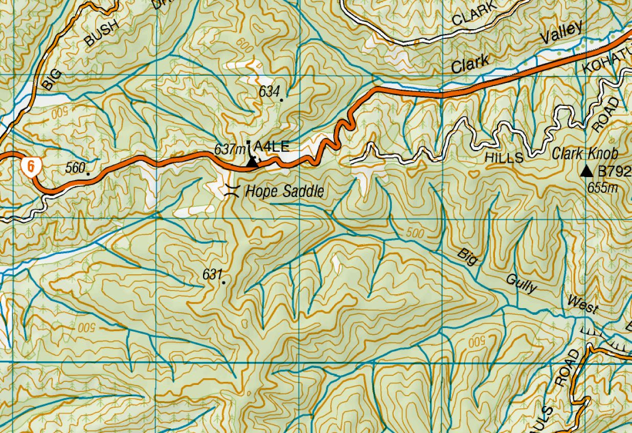
Hope Saddle Lookout is located on the top of one of the north-south facing ridges between Murchison and Nelson. It sits at an altitude of 637 meters which means it is the high point between the two places and one of the highest spots along the route of SH 6.
 |
| Map: Hope Saddle Lookout |
 |
| Start of the Hope Saddle Lookout Track |
From SH6 you turn off onto the marked sideroad to the Hope Saddle Lookout...it is a short road to a picnic area, toilets, track to the high point and car park. The high point is the location of the lookout with a flat hill located at the end of a 300 meter long track.
 |
| The track is 300 meters to the Hope Saddle Lookout |
The track is well marked and in excellent condition and though it climbs up to the hill top is is not very steep. The track is lined on both sides with regenerating Manuka forest so it is mostly shady and protected from the wind.
 |
| Nice track to the Hope Saddle Lookout |
On the top of the hill there is a trig point, information panels and a small viewing platform with a brass map of the surrounding peaks. There is a small clearing around these items and the tree line is far enough away that you have a near 360 view of the surrounding area.
 |
| Clearing at the Hope Saddle Lookout |
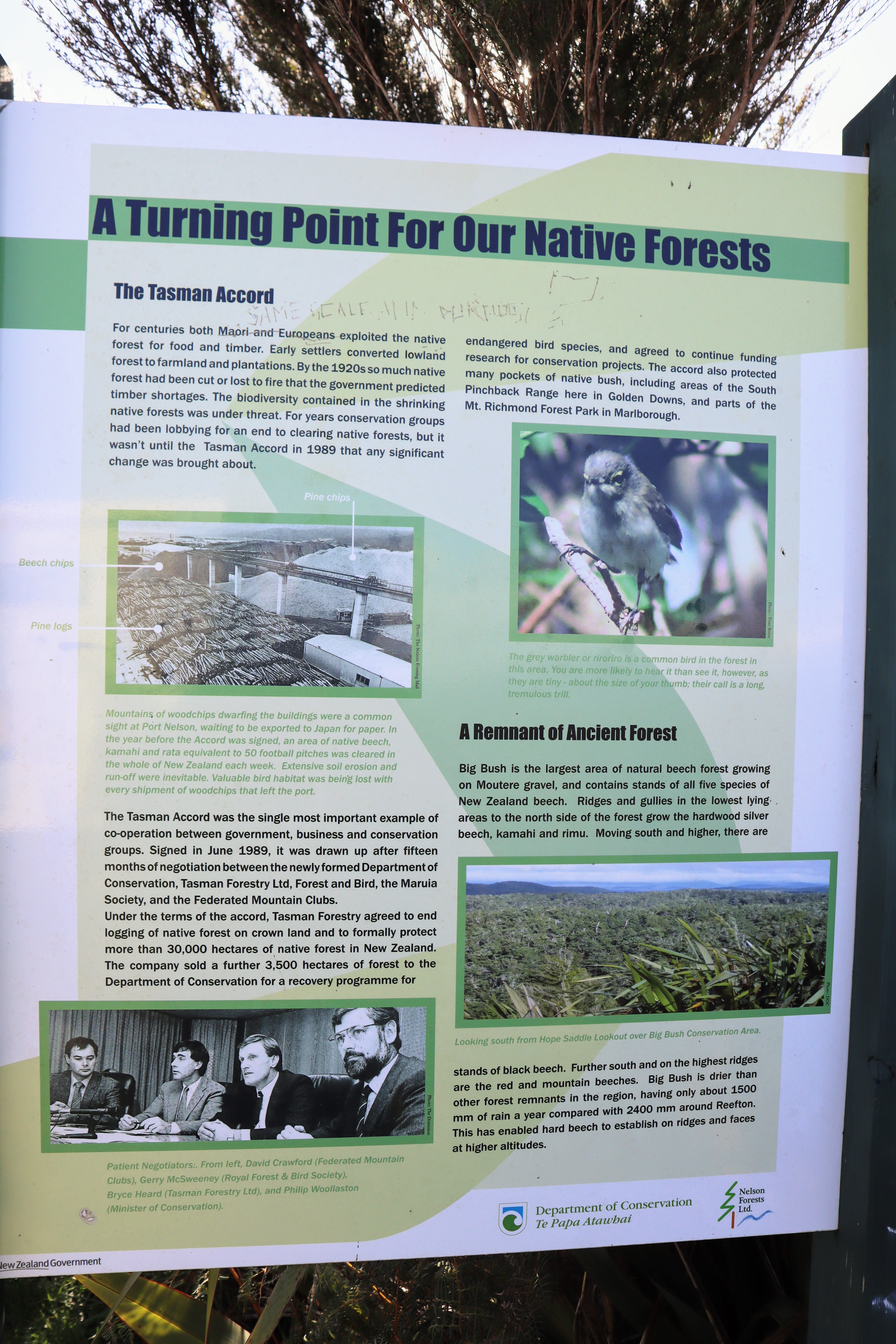
The two information panels at the Lookout have information about the Tasman Accords of the 1980's (which halted harvesting of native trees) and the hardship faced finding and building a route from Nelson to the West Coast through these hills.
 |
| Information panel at the Hope Saddle Lookout |
 |
| SH6 follows a historic route to Westport |
It is worth while making your way around the clearing at the Lookout to gain the best views of the surrounding area. I found that standing near the trig marker gives you the best views to the east and south while the platform was better for the west and north.
 |
| Platform and brass map at Hope Saddle Lookout |
This whole area of the Tasman District is heavily forested with only a small corridor of farmland along the bottom of the various valleys. To the west lie the Owen and Maring Ranges which rise to over 1800 meters. To the north is the Arthur Range with some peaks reaching 1700 meters including Mt Arthur and The Patriarch.
 |
| Maring Range from Hope Saddle Lookout |
 |
| Mt Owen from the Hope Saddle Lookout |
To the south lie the massive ranges around Nelson Lakes NP and right down the Buller Gap which is the area of flat land on either side of the Buller River. It was cloudy on the day but on a perfectly clear day you would be able to see right along the spine of the Southern alps from the Saddle.
 |
| Hope Saddle Lookout trig point (637 meters a.s.l) |
 |
| Looking down the Buller Gap from Hope Saddle Lookout |
To the north east you can see along and over the various ridgelines leading to Richmond and Nelson. The Richmond Ranges were clearly visible as were the exotic forest plantations stretching over the Golden Downs.
 |
| Cloud covers the mountains around Nelson Lakes NP |
I took the obligatory photo of me standing by the trig point....I have the mountains around Nelson Lakes NP behind me!
After about 10 minutes I headed back down to the car-park along the same track you take to reach the top.
 |
| Descending the Hope Saddle Lookout Track |
 |
| Road to the carpark at the Hope Saddle Lookout |
It takes about 5-7 minutes to walk along the track so it is not an arduous tramp by any means.
 |
| Near the end of the Hope Saddle Lookout Track |
The car park at the Hope Saddle Lookout is large enough for 10-15 vehicles and is sealed so you don't need to worry about getting stuck. There was a big group of what sounded like Dutch tourists at the Lookout with me...they had two campervans and a car so there were about 10 of them.
 |
| Hope Saddle Carpark with many Dutch tourists!!! |
You can see out to the area around Mt Owen with a great view of the peak...it was covered with snow after the recent series of storms we have had. This whole area is in the eastern part of Kahurangi National Park which runs along the roadside from near Murchison to the Motueka Valley.
 |
| Mt Owen from the Hope Saddle Lookout carpark |
There is a very basic picnic area next to the carpark with a small covered shelter, some picnic tables and a large grass covered clearing. There is a vault toilet located here but there is no potable water source so you must bring it with you. It would be a nice place to stop and break your journey if you were travelling from Nelson to the West Coast.
 |
| Hope Saddle Lookout picnic area |
 |
| Hope Saddle Lookout...picnic tables and toilet |
From the carpark it is possible to look down on to SH 6 between Murchison and Nelson. You can see several stretches of the road climbing over the surrounding ridge lines. They are surrounded by a mix of native and exotic forest as forestry is a huge part of the economy up around Nelson.
 |
| Hope and Maring Ranges from the Hope Saddle Lookout carpark |
 |
| Most of the local ridges run north to south...Hope Saddle Lookout carpark |
If you happen to find yourself driving this way you should really stop and have a look at the Hope Saddle Lookout. Walk up to the trig point and look around or simply stop and sit in the sun while you have a bite to eat. This is an attractive and most over looked spot...
Access:There is a short sideroad off SH6 at the top of the Hope Saddle. It is clearly marked with road signs on both sides about 400 meters from the turn off. Take care when driving back onto SH6 as it is winding and very busy.
Track Times:The track is only 300 meters long so 5-7 minutes walking time.
Miscellaneous:There is space for 10-15 cars, a toilet, picnic tables and a small covered shelter. No potable water at this location. This is a no camping area with hefty fines for Freedom Camping.