Showing posts with label Southern Alps. Show all posts

Monday, 21 November 2022

Lewis Pass National Reserve: Lewis Pass Tarn

Return to the tarn at Lewis Pass 

The first walk I finished on my recent trip to Nelson Lakes was actually the short walk to the tarn at Lewis Pass. I was passing by over Lewis Pas and stopped for a break here. I have been here many times in the past...it is always beautiful and the surroundings are stunning. 

View down the Lewis River Valley from Lewis Pass Tarn

Every visit to the Lewis Pass Tarn is different depending on the weather you encounter..it sets the scene for how you view your experience. 

Exploring the area around the Lewis Pass carpark:

I was on my way to Nelson Lakes NP for a couple of days and Lewis Pass is always a good spot to stop for a rest as it it is roughly 2-3 hours from Christchurch. It's good to get out and stretch your legs before tackling the downhill drive to Springs Junction. 

Carpark for the Lewis Pass Tarn/St James Walkway

Map: Lewis Pass and surrounds...

The carpark at Lewis Pass is just before you reach the highest point of the road on the eastern side of the mountains. There is space here for around a dozen cars and especially on fine days and weekends it will be full of trampers and voyageurs enjoying the surrounding mountains. 

Space for about 20 vehicles here at Lewis Pass

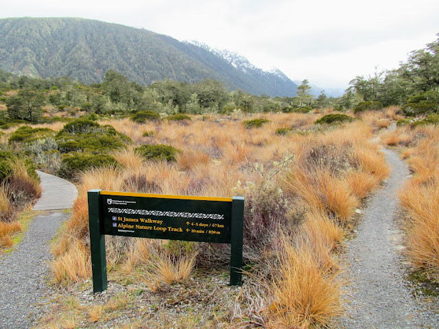
From the carpark there are a couple of tracks you can access...on the southern side of SH 73 is the track to the Lewis Pass Tops and the series of lovely tarns along the top of the range of mountains to the east of the Maruia River. On the carpark side of the highway there are tracks to the Lewis Pass Tarn, Lewis Pass Alpine Loop Walk and of course the St James Walkway.

View along the Maruia Valley to the Spencer Range

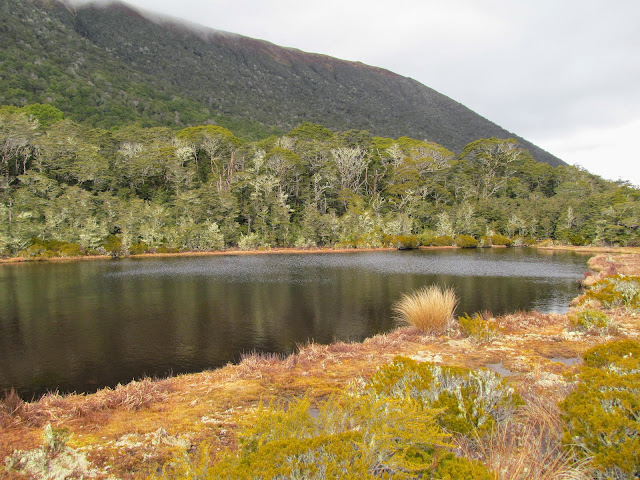
The tarn is moderately large and quite large waves can develop on the surface as the wind is often blowing across the pass with a bit of force. During colder weather I have seen the tarn completely frozen over though this only happens if there is a lot of snow laying on the ground at the pass.


The Libreto Range overlooks the Lewis Pass Tarn

Lewis Pass Tarn from the St James Walkway

You walk down the St James Walkway for about the first 400 meters of the track to where the track diverts along the Nature Walk. It is worth walking down to this end of the tarn just for the view back over the tarn and down the Lewis River Valley. 

View back over the Lewis Pass Tarn

The tarn is at around 900 meters a.s.l and it is one of the few alpine tarns here in New Zealand easily accessible from the road. Most of the others are atop mountain ranges and require you to walk a couple of hours to view them. 

Multiple tracks start at Lewis Pass

There is a day shelter, toilet and viewpoint at the eastern end of the tarn all along the same short side track from the carpark. The shelter is there for people walking off this end of the St James Walkway...it is open sided but it will keep the rain off you as you wait for a shuttle to collect you. 


Track to the Lewis Pass Day Shelter

Lewis Pass Day Shelter, Lewis Pass National Reserve

There is a watertank attached to the side of the shelter supplied from rainwater run off and along drop toilet just past the hut. You could easily make yourself reasonably comfortable here for a couple of hours...

Day shelter at Lewis Pass...water tank and toilet

The view from the lookout is across the tarn and down the Maruia River Valley to the Spencer Range. The Spencer Range has peaks above 2200 meters and includes mountains such as Gloriana, Una, Desa and the Fairie Queene. These were all names used in a Tennyson poem from the early 1800's. 


Lewis Pass Tarn from the lookout

There was still snow on some of the peak as we have had a late winter this year with  significant snow falls as late as October. It is starting to melt now but it will be an impedance for people crossing the high mountain passes through to the end of December. 


High points along the Spencer Range

To the north east of the tarn lies the Opera and Libretto Ranges and if you are here on a calm still day you can often take beautiful reflective images of the mountains on the surface of the tarn. 

Freyburg Range is to the west of Lewis Pass Tarn


The Opera Range is beyond the Lewis Pass Tarn

I was at the tarn for about an hour filming the tarn and also walking the Lewis Pass Nature Walk. I have vlogs on the way for both of these and they will be appearing on my You Tube channel in due course...

Quiet day at the Lewis Pass Tarn carpark

Lewis Pass is 400 meters west of the carpark

Lewis Pass is another 400 meters up the highway and it is one of the four ways you can drive from east to west over the Southern Alps. The others are Arthurs Pass, Haast Pass and Hope Pass. The West Coast is wetter than the east so when you travel one of these roads you will see a change in the vegetation with Beech forest and tussock lands dominating the east and dense Podocarp forest to the west. 

This is the northern terminus of the St James Walkway

I also walked along the Lewis Pass Nature Walk to get some material for a vlog about the track...I will cover that in a separate post!


Access: From SH 7 (Lewis Pass Highway) a short boardwalk track leads to the Lewis Pass Tarn lookout. You can access several other tracks from the carpark including the Lewis Tops Track, Alpine Nature Loop Track and the St James Walkway.
Track Times: It is two minutes to the Lewis Pass Tarn from the carpark (follow the signs). Other tracks are from 30 minutes to several days depending on length.
Miscellaneous: The Lewis Pass Tarn is in a high alpine area and as such is prone to extreme weather. There is a toilet and trampers shelter near the tarn available to all visitors. Severe avalanche risk on the Lewis Pass Tops & St James Walkway in winter/spring so only proceed if safe (check the Avalanche Advisory website)
YouTube: Lewis Pass Tarn

Monday, 16 May 2022

Tramping Literature: Uprising by Nic Low

 A Maori perspective on crossing the Southern Alps...

I enjoy reading books about the outdoors with particular interest in tramping, camping, climbing and outdoor skills and anything dealing with outdoor history. I recently read an excellent book by Kiwi author Nic Low entitled Uprising that I would like to recommend to you.

Uprising by Nic Low

Uprising is about a series of journeys Nic undertook around the South Island following the old Pounamu/Greenstone trails from the East Coast to the West Coast over the Southern Alps. There was a lively trade in pre European times between the two coasts with Pounamu/Greenstone ( a type of Jade) being one of the main trade items. 


About the author:

Nic Low is a writer of Ngai Tahu and European descent who was born in the South Island but now lives in Australia. He writes about wilderness, technology and Maori issues and has been widely published both in book form and articles in magazines and newspapers. 

The author Nic Low in his element...

Nic is a keen tramper, outdoor person and climber with a notable list of accomplishments. He has won several awards for his literary work and his style is engaging and very easy to read.


About the book: Uprising...

 Nic decided to write a book about the many traditional Maori pathways which exist from the east to west coasts of the South Island. There was a well established set of routes which the local Iwi called Ngai Tahu used to transit the Southern Alps. As you can imagine these routes were difficult and hazardous to use...and not to be undertaken lightly. 

Arthurs Pass was a traditional Maori route to the West Coast

Prior to European settlement one of the most prized materials in New Zealand was Pounamu...a type of local Jade.  Pounamu is a handsome, very hard rock and can be sharpened and shaped into many forms meaning it was useful for weapons, tools and decorative items. 

A Pounamu warclub or Mere

Pounamu is only found in the rivers on the West Coast mainly south of Hokitika. Trade in the material was strong and possession of the source of the rock a guarded secret. Pounamu was the main reason Maori crossed the Southern Alps.

Map: Pounamu deposits in the South Island

Pounamu/Greenstone was a valued commodity...

Journeys across the Alps were also undertaken to gather seasonal food, for war and to visit relatives on either coast. Far from being untouched virgin wilderness the area was named, known and owned long before Europeans arrived on the scene. 

Lake Brunner was one of many valued seasonal food sources

Nic's journey was informed by Ngai Tahu's traditional oral histories of the land they lived in and this was an important facet of the planning. This was combined with modern maps of the terrain and the experiences of others who had crossed these pathways before him. 

He crossed the Southern Alps more than a dozen times and tried to see the land as those first travelers must have seen it. The whole book is infused with the culture and history of the local Maori which is rare in books about the outdoors even in New Zealand. 


Hurunui/Harpers Pass was the main route to the West Coast

Covering many different areas of the Southern Alps the author crossed over some of the well known passes such as Arthurs Pass, Harpers Pass and Haast Pass and some lesser known like Harmon Pass, Copland Pass and Whitcombe Pass. Interestingly all of these passes had Maori names long before they were named after European explorers and settlers. 

In the Upper Waimakiriri Valley...the route to Harmon Pass

This was a book I could not put down...it was enthralling. I have talked to others who have read it and their sentiments were the same. It is an interesting, compelling and revealing look at a part of Maori culture very few people truly understand. I cannot recommend it to you more strongly. This should be an essential item on every trampers bookshelf.

Sunday, 26 September 2021

Lewis Pass National Reserve, Lewis Pass Tarn Walk: 21 September 2021

 Crossing from East to West at Lewis Pass....

The first track we finished on our recent camper van holiday to the West Coast was the short walk along the tarn at Lewis Pass. I have been here a couple of times in the past but Karen had never walked up to see the tarn and it is beautiful and in a stunning location. We decided to stop and have a look at the tarn even though we had only been driving for an hour at that point... 

Lewis Pass Tarn from the eastern end.....

Jon at Lewis Pass Tarn, Lewis Pass National Reserve

Several tracks start from this locale and there are picnic tables, toilets and a trampers shelter located here which can be used by all visitors. 


Track Junction for St James Walkway and Lewis Pass Nature Track

Our Britz camper van at Lewis Pass carpark

It was the first of several walks and tracks we covered over the week and was a great starting point to the holiday.


A short stop at Lewis Pass Tarn:

There is a carpark at Lewis Pass just before you reach the highest point of the road where you can stop for a rest after climbing up from either Springs Junction or the Lewis River Valley. There is space here for around a dozen cars and especially on fine days and weekends it will be full of trampers and voyageurs enjoying the surrounding mountains. 


First view of the Lewis Pass Tarn from the track...

There is boardwalk to the eastern end of Lewis Pass Tarn

From the carpark there are a couple of tracks you can access...on the southern side of SH 73 is the track to the Lewis Pass Tops and the series of lovely tarns along the top of the range of mountains to the east of the Maruia River. On the carpark side of the highway there are tracks to the Lewis Pass Tarn, Lewis Pass Alpine Loop Walk and of course the St James Walkway.


Moody setting at Lewis Pass Tarn with approach bad weather...

Map: Lewis Pass and surrounds...

I am going to stop here in mid October when I am enroute to a tramp in Abel Tasman NP and I am going to walk the Alpine Nature Loop Track. It skirts the tarn and then heads off to the left of the track and meanders through smaller tarns, swamp and gnarled Beech forest before heading back along the St James Walkway to the carpark. 

The Lewis Pass Tarn is back by the Opera Range

The tarn is moderately large and on a clear still day you will get reflections of the Opera Range on the surface. During colder weather I have seen the tarn completely frozen over though this only happens if there is a lot of snow laying on the ground at the pass. 


Heading down the start of the St James Walkway

Western end of Lewis Pass Tarn, Lewis Pass National Reserve

Karen and I walked down the St James Walkway for about the first 500 meters of the track to where the track starts to descend down to the Maruia River and Cannibal Gorge. There is a suspension bridge there where the track crosses the Maruia and if you have the time and inclination the two hour return trip is an excellent day tramp.


Goblin forest as you start down towards Cannibal Gorge

A DOC intentions kiosk at the start of the St James Walkway

St James Walkway drops down to the Maruia River

Cannibal Gorge suspension bridge in 2015

We had places to be so we didn't venture that far instead we turned around and started walking back to the camper parked near the tarn. It was super moody in the mountains as there was a rain front moving in so there were dark threatening clouds on the tops. It started to lightly rain as we got back to where we could see the van and this continued for the rest of the day. 


Heading back towards Lewis Pass Tarn...Mt Technical to right

The Libretto Range to the east of Lewis Pass Tarn

Lewis Pass itself is another 400 meters up the highway and it is one of the four ways you can drive from east to west over the Southern Alps. The West Coast is wetter than the east so when you travel one of these roads you will see a change in the vegetation with Beech forest and tussock lands dominating the east and dense Podocarp forest to the west. 


The carpark at Lewis Pass.....Lewis Pass National Reserve

View back down the Lewis River Valley from the carpark

It was a lovely way to start several days of walking and as always a great wee spot to take a break when driving across the Southern Alps. You have probably driven past the carpark numerous times over the years and never stopped but you should next time to take in the splendor of the surrounding country.


Access: From SH 7 (Lewis Pass Highway) a short boardwalk track leads to the Lewis Pass Tarn. You can access several other tracks from the carpark including the Lewis Tops Track, Alpine Nature Loop Track and the St James Walkway.
Track Times: It is two minutes to the Lewis Pass Tarn from the carpark (follow the signs). Other tracks are from 30 minutes to several days depending on length.
Miscellaneous: The Lewis Pass Tarn is in a high alpine area and as such is prone to extreme weather. There is a toilet and trampers shelter near the tarn available to all visitors. Severe avalanche risk on the Lewis Pass Tops & St James Walkway in Winter/Spring so only proceed if safe (check the Avalanche Advisory website).