...along the Crater Rim Walkway...
Way back in early February I went and walked another Port Hills section of the Christchurch 360 Trail on a warm and sunny day. This was a short section from the top of Kennedys Bush Track along the Crater Rim Walkway to the Sign of the Kiwi.
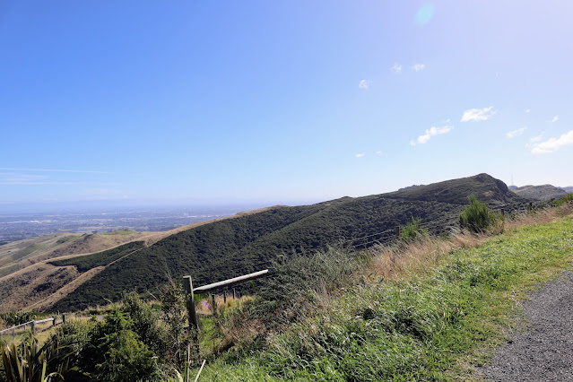 |
| Worsley's Spur from near Kennedys Bush Track |
One of the highlights of any section along the Port Hills are the magnificent views out over the Canterbury Plains. On a clear day you can see from the Kaikoura Peninsula right south to down near Oamaru.
 |
| Canterbury Plains from near Kennedys Bush Track |
In places you can also see down into Lyttelton Harbor and the green of the plains and the blue of the water in Lyttleton really speak to what Christchurch is all about.
 |
| Looking down Lyttleton Harbor from the track |
This section of the 360 Trail is what I would term Urban Wilderness...it is scrub, bush, rock and farmland but you can still see the sprawl of Christchurch close to hand. Not quite an urban area but certainly not typical New Zealand backcountry.
 |
| View to the south from the Summit road on the Port Hills |
Anyway...enough of that. Let's put our walking shoes on and traverse the trail between Kennedys Bush Track and Dyers Pass.
Kennedys Bush Track:
The start of this section is at the top of the Kennedys Bush Track up above Westmorland. I got Karen to drop me near this point and I then made my way home by foot. The previous 360 section starts down at Halswell Quarry and climbs up the hills to this point.
 |
| Map: Christchurch 360 Trail: Kennedys Bush/Sign of the Kiwi |
I walked that section way back in 2016 when I was working on completing the whole Christchurch 360 Trail.
 |
| Carpark at top of Kennedys Bush Track |
 |
| Entrance to Kennedys Bush Track on Summit Road |
There is a fence and stile at the top of Kennedys Bush Track and a small parking area next to the farmers access point to the track. If you are driving to this point ensure you leave enough space to let farm vehicles get past.
 |
| MTB riders and walkers at Kennedys Bush Track |
 |
| Great views out over the Canterbury Plains |
 |
| CCC sign at top of Kennedys Bush Track |
Directly across from the Kennedys Bush Track is a short connector track which takes you up to Mitchells Track which runs around to Dyers Pass. It is well sign posted with Christchurch 360 signs and obviously leads up hill to the main track.
 |
| Access to Mitchells Track from the Summit Road |
 |
| ...follow the Christchurch 360 Trail signs... |
The track is the standard mown grass that you will find right along the Port Hills and makes for easy walking. You are totally exposed up here so make sure you are ready for hot sunny weather and inclement conditions.
 |
| Climbing up to Mitchells Track from Kennedys Bush Track |
 |
| Mitchells Track comes into sight |
Eventually you will connect with the Mitchells Track...go left towards Dyers Pass. If you head to the right you will eventually arrive at the Sign of the Bellbird which is another of the rest stops built for the proposed Harry Ell Walkway along the Port Hills.
In the early 1900's there was a plan for a series of rest stops along the route of a proposed track from Evans Pass to Akaroa. Only three were built: Packhorse Hut, Sign of the Bellbird and Sign of the Kiwi but several others were planned. The Great War and a lack of money eventually stymied the plan...
 |
| Junction of connector track with the Mitchells Track |
There is some new native planting on the hills around this point. Most of the existing cover was burnt down in the 2016 Port Hills fires. The Canterbury Regional council are slowly replanting many areas along the tracks with natives. Eventually there will be a very nice strip of native bush right along the crestline of the Port Hills.
 |
| New native planting along Mitchells Track |
 |
| On Mitchells Track heading to Dyers Pass via Pt.490 |
 |
| Descending down from the hill near Sign of the Bellbird |
You follow the obvious track around the hills to the first of a series of carparks you will find along the track. It was pleasant and very easy walking through shoulder high gorse and broom.
 |
| Descending to the first carpark on Mitchells Track |
 |
| On Mitchells Track enroute to Sign of the Kiwi |
There were half a dozen vehicles parked here as a group was climbing on some nearby bluffs. I stopped for a water break before continuing on my way...
 |
| At the first carpark on Mitchells Track, Port Hills |
 |
| Climbers scale cliffs near Sign of the Bellbird |
There is another Christchurch 360 marker on the far side of the carpark and it heads up and over some low hills. There is native bush right up to the side of the track here and this is the only bit of this section with any cover from the sun.
 |
| Following Mitchells Track above Hoon Hay Reserve |
 |
| Rock and grass track near Hon Hay Reserve |
There are some spectacular views over Lyttleton from along the track. You can see right up the harbor and have excellent views down to Quail Island and the Head of the Bays.
 |
| View down to Lyttleton Harbor from Mitchells Track |
 |
| Closer view of Quail Island from Mitchells Track |
The week I was walking this track was the same the Sail GP event was happening so Lyttleton was full of yachts both competing and watching the yachts. There were a few people along the track sitting and watching through binoculars. Quail Island would have been the sweet spot as the yachts passed right by the island.
|
| Great view down Lyttleton Harbor from Mitchells Track |
 |
| Yachts on Lyttleton Harbor on Sail GP weekend |
You make your way along Mitchells Track to the carpark just below Pt.490 which is a high point up above Governors Bay. This peak is now a QEII covenanted reserve and is slowly reverting to native bush. There is now a protected bush enclave from Hoon Hay Valley over the hills to Governors Bay.
I wonder if QEII reserves will become KCIII reserves now Charles has taken the throne. They may retain the old name in the same way as the Duke of Edinburgh awards. It just doesn't make a huge amount of sense to change the name. Of course the Duke of Edinburgh is now Edward Windsor so it is not exactly the same.
It will be interesting to see...
 |
| View to Pt. 490 from Mitchells Track |
You soon arrive at another carpark and then start the short but steep climb up the old farm track on the western side of Pt. 490.
 |
| Another carpark along Mitchells Track near Pt. 490 |
 |
| Climbing up to the track around Pt. 490, Port Hills |
 |
| Continuation of Mitchells Track past Pt. 490 |
After first passing through some native bush you are back out in the open as you follow the path through some old farm paddocks. Pt. 490 is to your right along here and you can see how the native bush is slowly starting to colonise the hillside.
 |
| View back past Pt. 490 to Cass Peak |
 |
| On Mitchells Track on the north flank of Pt. 490 |
There are a lot of reserves along the Port Hills now and looking down into the valleys you pass you will often find regenerating forests. Hoon Hay Valley is typical of this with extensive native bush from near the Summit Road right down to the valley floor.
 |
| Bush in the Hoon Hay Valley, Port Hills |
 |
| First view of Pegasus Bay from Mitchells Track |
There is a stile over a fence past Pt. 490 and if you cross it you will find tracks up to the top of Pt. 490, down to Governors Bay and to a lookout point. There is a map here showing all of the bush tracks in the area so go have a look...
 |
| Stile to the tracks and lookout above Governors Bay |
 |
| Tracks to Governors Bay and up to Pt. 490, Port Hills |
 |
| Map of track network in Ohinetahi Reserve |
I went and had a look from the lookout and there is an excellent view of this end of Lyttleton Harbor and down to Governors Bay.
 |
| Governors Bay and Lyttleton from above Ohinetahi Reserve |
After a bit of time looking at the lovely scenery I jumped back over the fence and continued on my way. I headed along the track over a small hill and down to the point where the track crosses the Summit Road.
 |
| Heading back over the stile to Mitchells Track |
 |
| Distant view to Marley's Hill from Mitchells Track |
 |
| You cross Summit Road at this carpark |
After crossing the Summit Road you continue along a path down past some houses on a grassy verge off to the side of the road. Watch for traffic when crossing the road as it is often busy with cars and cyclists.
 |
| Summit Road crossing place near Worsleys Road, Port Hills |
 |
| Christchurch 360 sign along the Summit Road |
You continue across Worsley's Road and then along the eastern flank of Marley's Hill. Marley's Hill is the high point and top terminus for the Christchurch Adventure Park. There are a number of MTB tracks on the north side of the hill going down into Cracroft Valley.
 |
| Worsley's Road branches off the Summit Road |
 |
| Mitchells Track sidles above the Summit Road |
The track continues down the side of Marley's Hill just above the Summit Road. You continue along the track till you reach another crossing point about a kilometer down the hill.
 |
| Heading around the east side of Marley's Hill |
 |
| View to Lyttleton/Banks Peninsula from near Worsley Road |
 |
| On Mitchells Track near the MTB track, Marley's Hill |
 |
| Mitchells Track on east side of Marley's Hill |
You eventually reach a point where the track crosses back across the Summit Road...cross the road carefully and continue along the track on its right hand side.
 |
| Distant Sugarloaf and high point above Dyers Pass Road |
There are some excellent views of the Head of the Bays and Governors Bay from an area of flat ground near the road crossing. The tide was fully in so all of the bays had water in them. It is very picturesque...
 |
| Head of the Bays from Mitchells Track, Port Hills |
 |
| View towards Gebbies Pass at the head of Lyttleton |
One of the MTB tracks down Marley's Hill passes close to the Summit Road here so I stopped and watched the riders descending the hill with various levels of skill and temerity. It is steep and twisting so a certain amount of control is required to stop you from shooting off the track and injuring yourself.
 |
| MTB riders passing the crossing point on Summit Road |
 |
| Mitchells Track continues on the east side of Summit Road |
Mitchells Track is leading you down towards Coronation Hill which is the high point just behind the Sign of the Kiwi. There are multiple tracks here so follow the one closest to and just above the Summit Road. Other tracks here lead to Governors Bay and around the side of the hills.
 |
| Sugarloaf is one of the higher points on the Port Hills |
There is a good view from the track of the remnants of the forest in the Cracroft Valley. Most of the forest was wiped out in the Port Hills fire but some of the trees are slowly regenerating as they are exotic Pines which favor a periodic fire event.
 |
| View down the Cracroft Valley from the Port Hills |
There are views to the Sugarloaf for the rest of the track. The Sugarloaf is a high point on the Port Hills with the TVNZ transmitters on top. Sugarloaf is one of the most distinctive feature of the Port Hills and the antennae there can be seen as you drive into and around Christchurch. This is our Hollywood sign, Table Mountain or Christ the Redeemer.
 |
| Heading down towards Coronation Hill through ferns |
 |
| Coronation Hill with Sugarloaf in the distance |
 |
| Viewing point looking towards Lyttleton Harbor |
If you look closely you can see the spectator vessels lined up off Diamond Harbor to watch the Sail GP event. The competitors were racing up and down Lyttleton Harbor for most of the afternoon. There was much excitement about the event being held in Lyttleton but it just doesn't interest me...I am no sailor!!
 |
| Sail GP spectators yachts off Diamond Harbor |
The actual course of the Christchurch 360 Trail is around the eastern flank of Coronation Hill. There is a sign and Christchurch 360 trail markers to show you the way. I just continued to follow the main track down to the left of Coronation Hill as I was keen to finish the walk.
 |
| Signs lead you around the east side of Coronation Hill |
Either way will ultimately lead you to the Sign of the Kiwi so choose your own option...
 |
| On the west flank of Coronation Hill, Port Hills |
 |
| Dyers Pass Road winds down to Cashmere |
Mitchells Track ends at the driveway for the Sign of the Kiwi café. There is a sign located next to some steps which will take you down to the road. There is limited information on this sign regarding the Christchurch 360 Trail.
 |
| Approaching the end of Mitchells Track |
 |
| CCC sign near Sign of the Kiwi |
The track heads down onto the Summit Road and from here you are walking on the road heading towards Dyers Pass.
 |
| Start/end of Mitchells Track near Dyers Pass |
 |
| Walking down the Summit Road to Sign of the Kiwi |
From here you walk down the Summit Road to the carpark opposite the sign of the Kiwi. This is the end of the track and the end of this section of the Christchurch 360 Trail. From here you can arrange transport or continue down the Harry Ell track which starts close to the Sign of the Kiwi.
At the Sign of the Kiwi...
The end of this section is at the Sign of the Kiwi on Dyers Pass. This is the pass between the Cracroft Valley and Governors Bay and is one of the four ways to travel over the Port Hills. The others are Evans Pass, the Bridle Path and Gebbies Pass.
 |
| Sign of the Kiwi at Dyers Pass carpark |
 |
| Sign of the Kiwi café is open Monday-Sunday |
There is a decent café located at the Sign of the Kiwi and it sells coffee, snack's, ice-cream and cold drinks. There are a couple of tables and a number of benches outside that you can sit on. It makes a great meeting point for the various walkers, runners, riders and sundry folk who stop here.
During the week there is usually a park directly opposite the café but over the weekend you will find it hard to find a parking space near here. Most people park on the side of the road uphill of the pass.
 |
| There are toilets and water at the Sign of the Kiwi |
The next section of the Christchurch 360 Trail starts across Dyers Pass Road. From the track entrance you will be climbing up the Crater Rim Walkway as you make your way up to and past the carpark for the Sugar Loaf. Following the Crater Rim Walkway will take you to the Bridle Path, Mt Cavendish and ultimately right out to Evans Pass.
 |
| Continuation of the Christchurch 360 Trail below Sugarloaf |
This is a nice section of the Christchurch 360 Trail and the highlight is the views out over the Canterbury Plains and down into Lyttleton Harbor. On a clear, sunny day it is hard to beat for a view...
Access: From the top of Kennedys Bush Track cross the Summit Road and head along Crater Rim Walkway towards Dyers Pass. You stay on the same track all the way to the Sign of the Kiwi and the route is well sign posted and marked.
Track Times: From the top of Kennedys Bush Track it is roughly 2 hour to the Sign of the Kiwi.
Miscellaneous: This track is exposed to all weather so it can be blisteringly hot and cold, wet and windy. Come prepared for all eventualities. Cafe, water and public toilets at Sign of the Kiwi.
Next Track Section: Dyers Pass to Bridal Path or out to Evans Pass
Previous Section: Halswell Quarry to Summit Road on Kennedys Bush Track


