|
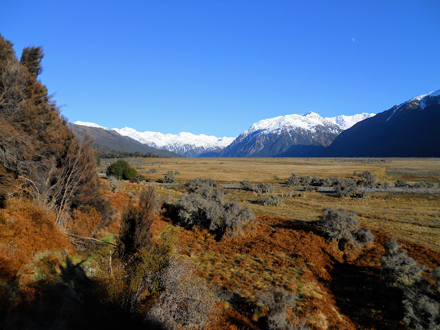
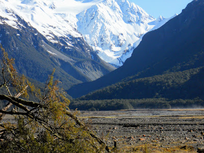
| Crow Valley, Mt Rolleston from Turkey Flat |
Heading to Anti Crow Hut
It is surprising but I have never been up to the head of the Waimakiriri before, even though it is considered by many as the spiritual home of Canterbury climbing and tramping. The old Carrington Hut was one of the first trampers hut built by the CTC way back in the 1890's.
Back in the 1960's-70-80's the upper valley would have been full of climbers and trampers who came up on the Friday night train. They would be making for places like Carrington Hut, Mt Rolleston, Waimakariri Falls the Three Passes tramp and the Upper Rakaia river.
It is much quieter these days.
 |
| Sunrise from Porters Pass on SH 73 |
 |
| SH73: On the road to Arthurs Pass |
My original idea was to cross the Waimakiriri from the car-park at Klondyke Corner and walk up to the hut using the
standard route to Carrington Hut. The river was high, there has been a lot of snow this year and the water levels are still too deep and swift to allow individual crossings of the river.
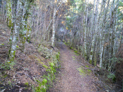
Instead I used O'Malleys Track which is the name for the flood track running along the bottom of Bealey Spur.
 |
| From SH 73 to Anti Crow Hut via Turkey Flat |
Don't park your car at this car park overnight, it is the worst spot in Arthurs Pass NP for car thefts & break-ins. It is fine for a day trip as you are back before dark, which is when most break ins occur.
 |
| O'Malleys Track car park, Arthurs Pass NP |
 |
| Start of O'Malleys Track to the Waimakariri Valley |
The track starts off by climbing up high to get above a gorge running down this side of Bealey Spur, total height gained would be 80 meters then you sidle the side of the spur for about 45 minutes - 2 kilometres.
 |
| O'Malleys Track: Initial climb to sidle track (about 80 meters) |
There are occasional views out across the river towards Klondyke Corner on the valley flats opposite.
 |
| Klondyke Corner from the O'Malleys Track |
Initially the track is benched with a nice camber and surface, this quickly degenerates into your standard DOC back country track. There is a bit of windfall on the track, no doubt damage caused by the heavy winter storms earlier this year.
 |
| O'Malleys Track: Initial sections are benched... |
 |
| Then turn into a mud scramble! |
You can just make out a couple of camper vans on the far bank of the river, this is the access point if you want to attempt a crossing of the Waimakariri River. It saves about an hour but is much more dangerous than just walking along the flood track. Literally dozens of people have drowned in the Upper Waimakariri...it is not to be trifled with.
 |
| Tourists camping at Klondyke Corner, from O'Malleys Track |
After about 45 minutes you get close to the end of the sidle, and start heading down to Turkey Flats.
 |
| Approaching Birch Nook on O'Malleys Track |
Below is the only significant side stream you cross on this track, doesn't look like much really. Then you notice the piles of drift wood debris around the trees near the river banks. I measured one, it was up to my knee so about 50 cm deep on the river bank which is 70-80 cm above the stream bed.
That's waist deep water on me, and I'm not short!
 |
| Only major stream that must be crossed, note flood debris! |
Once you get to the end of the flood track the upper valley opens up before you.
 |
| O'Malleys Track: Heading down onto Turkey Flat |
Turkey Flat is a large debris fan from Jordan Stream, it takes about an hour to walk across it mainly due to the gravel you are walking on for most of that time. It is big lumpy stuff brought down by the streams in the area. It is awkward to walk on and you keep wobbling around.
 |
| Mt Bealey across the Waimakiriri valley |
 |
| View back to Bealey Spur and O'Malleys Track |
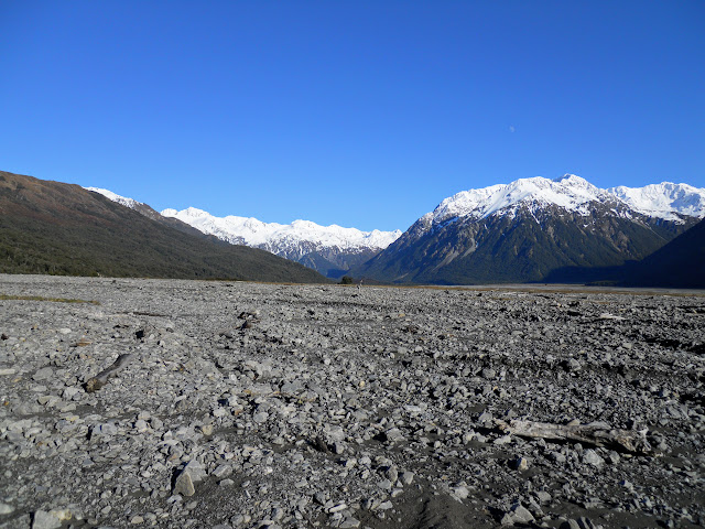
Jordan Stream is a vast expanse of gravel, the main river bed is about a kilometre across, totally bone dry. I would imagine that when a good olde Nor' Wester starts bucketing down it soon fills to the brim, there is no covering vegetation so it must get washed away regularly by all the water.
 |
| View up Jordan Stream from stream bed |
 |
| Looking West to Mt Stewart and headwaters from Jordan Stream |
The further you walk the better the views of the surrounding mountains, Crow Valley starts to open up as you get closer to the hut.
 |
| Waimakariri Valley: Anti Crow Hut is over the spur to left |
 |
| View of Mt Stewart, Crow Valley from Waimakariri Valley |
The final part of the route is a short track over a bush spur, when the river is low you can forgo the pleasures of the track and just walk up the dry river bed. Be aware there is a bit of a hairy down climb right at the end of the track, not high just difficult.
 |
| Anti Crow Hut: climbing over last spur |
 |
| Track heading down to Anti Crow Flat |
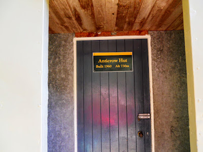
Anti Crow Hut is a classic ex NZFS six bunker, it is in a nice location sited in a bush finger with expansive views of the valley. I believe this is the second hut on the site, being built in 1960 to replace an even older hut. DOC have obviously been in to do some upkeep as the hut was looking in excellent condition.
 |
| Anti Crow Hut (1960) |
 |
| Anti Crow Hut: come on in folks..... |
It has a new coat of paint outside and is fairly tidy inside, 6 bunks but you could probably get another 4-6 people in on the flood if needed. Most visitors are people on day tramps, mountain runners and climbers/trampers on their way to/from
Carrington Hut and the Three Passes Route.
I was the first person to visit the hut since the 5th September.
 |
| Interior of Anti Crow Hut |
 |
| Anti Crow Hut: interior, opposite end of hut |
 |
| View east to Klondyke Corner from Anti Crow Hut |
There are some impressive views of the South face of Mt Rolleston (2271 meters) as well as the Crow Valley. I will eventually get around to visiting the Crow Valley Hut, it is a bit of a tricky trip as you need to cross the Waimakiriri a couple of times to get there.
 |
| Rolleston Glacier from near Anti Crow Hut |
 |
| Mt Rolleston (2271 meters), Arthurs Pass NP |
The hut looks good in its new coat of paint, I especially like the sheet of clearlite DOC have retrofitted to improve the light inside the hut. Makes it so much brighter and cheerful.
 |
| Close view of Anti Crow Hut |
There is a big flat area in front of the hut, if the hut was full you would have your choice of spots for tenting.
 |
| River flats in front of Anti Crow Hut |
 |
| Crow Valley, destination for future trip, Avalanche Peak to right |
I ate my lunch in the hut and then made my way back the way I had arrived. The wind picked up a little around 12 noon but it was still nice walking weather.
 |
| Waimakariri Valley: heading back towards Jordan Stream |
The hut is just on the other side of the bush spur coming in from the left, the track meanders for about 700-800 meters through the bush.
 |
| Anti Crow Hut is just the other side of this bush spur |
There is a really obvious ground trail in those places with vegetation, the route is also marked by snow poles as well.
 |
| Obvious ground trail across Turkey Flat |
 |
| Waimakariri Valley: gravel bash supreme! |
I don't normally listen to the MP3 while tramping but with that big gravel flat to cross again I needed the inspiration, it worked because it took me half the previous time to get back to the start of the flood track.
 |
| Jon bopping out crossing Jordan Stream |
 |
| More getting down...Waimakariri River Valley |
Jordan Stream....that's a whole lot of gravel to walk over, especially when viewed from a log in the middle of the stream bed.
 |
| View up the Waimakariri Valley from bed of Jordan Stream |
 |
| O'Malleys Track: reason for the sidle track: bluffs! |
As you can see the Waimakiriri comes right up against the side of Bealey Spur, the water was flowing deep and fast in this channel.
 |
| Nice river pool approaching Bealey Bridge |
This is the last climb before you start descending down to the car park near the Bealey Bridge. I agree with the guide books: this track needlessly goes up and down but it is a godsend for accessing the upper reaches of the Waimakariri river valley.
 |
| O'Malleys Track..scrappy track high above the Waimakariri River |
I will be coming back some time in the future to visit the Upper Waimakariri River, I'm keen to visit the massive 36 bunk Carrington Hut as well as the much more modest Waimakariri Falls Hut.
Access: From SH 73 at the Bealey Bridge, park at the O'Malleys Track car park and follow the flood track to Turkey Flat, follow the marked track towards the head of the Waimakariri Valley.
Track Times: 2-3 hours to Anti Crow Hut Hut, another 2 hours to Carrington Hut
Hut Details: Anti Crow Hut: standard, 6 bunks, wood burner, water tank, toilet: Carrington Hut: serviced (CTC owned, DOC administered), 36 bunks, radio, wood burner, water tanks, wood shed, toilets
Miscellaneous: Both the Waimakariri and Anti Crow Rivers are dangerous, numerous people have drowned in both, care needed when crossing. Jordan Stream prone to flooding in heavy rain.