Sunday 15 August 2021

From the vault: A Visit to the Kaimanawa Ranges back in the late 1980's

 ...looking back through time...

Here is the first of a new series of posts I will be writing about previous tramping trips I have undertaken. I have decided to call this From the Vault and I will be showcasing historic tramps I have previously covered in the blog. To start with lets take a look at a trip I did way back in 1987 when I first started my career in the New Zealand Army.


Mt Ruapehu from inside the Waiouru Training Area


A bit of background...I served in the New Zealand Army from 1987 to 1991 as a member of the Corp of Signals. I was posted to Waiouru ATG, Addington Barracks and Burnham Military Camp over that time. Waiouru used to be the main training camp for all new enlisted and commissioned soldiers as it has extensive areas of open tussock-land, mountains, volcanic desert, forest and rolling hills ideal for training. 


The Waiouru Army Training Area...tussock and hills!!!

While I was doing my basic soldier training we went for an exercise to the far back blocks of the Army Training Area along the border with the Kaimanawa Mountains. It is wild and seldom visited country up along the northern edge of the Training Area and few soldiers let alone civilians ever get to visit it.

 We criss-crossed between Kaimanawa Forest Park and the Waiouru ATA as we walked out to the Desert Road between Waiouru and Taupo.

The Desert Road near the northern edge of Waiouru Training Area


Anyway...here is a link to the article about one of the more remote places in New Zealand I have visited...the Kaimanawa Mountains


Wednesday 11 August 2021

Te Ahu Patiki...dawn of a new conservation park on Banks Peninsula

Securing the future of Te Ara Pataka...

 Another exciting new conservation project has just commenced on Banks Peninsula around Mt Herbert/Mt Bradley. A group of interested parties lead by the Rod Donald Trust have just brought a large parcel of land on the southern side of Lyttleton Harbor above the Orton Bradley Estate. The plan is turn this area into a new park with the interim name of Te Ahu Patiki.

Map: the Te Ahu Patiki Conservation Park

Te Ahu Patiki is a 500 ha parcel of land including the summits of both Mt Herbert and Mt Bradley two of the highest points on Banks Peninsula. The land was previously a part of Louden Farm's owned by Phillip King and Sarah Lovell-Smith. The two families are long term land owners on Banks Peninsula and have lived here for over 100 years. 


Signatories at the deed settlement ceremony for Te Ahu Patiki in 2021

The summit of Mt Herbert is within Te Ahu Patiki

The Rod Donald Trust in partnership with Orton Bradley Estate, the Department of Conservation and Te Hapu o Ngati Wheke started negotiations to purchased the land in July 2021 with the intention of creating a new conservation park. A crowd funding appeal was the final piece of the puzzle and the $400 000 raised enabled the partners to amass the $2 million dollars needed to acquire the land. 

Most of these hills are contained in Te Ahu Patiki

The partnership have a long term vision to restore native bush to most of this new park so that one day there will be a sizeable area of native forest around the two peaks. With the land owned by the Rod Donald Trust and other DOC reserves along Te Ara Pataka this will create a native forest corridor from near Hilltop Tavern to Packhorse Hut on Kaituna Pass. Together the reserves will cover over 1700 ha of land providing an ecological hotspot on Banks Peninsula. 

In Mt Sinclair Reserve, Te Ara Pataka in May 2020

The inclusion of the Orton Bradley Estate is a excellent action as it will ensure there is a sea to summit walking corridor from Lyttleton Harbor right up to the top of Mt Herbert. Orton Bradley Estate is a 600 ha reserve immediately below Te Ahu Patiki. It is a farm park with extensive walking tracks, camping areas and an outdoor education center. 

Looking up the Mt Herbert Walkway, Orton Bradley Estate

The Orton Bradley estate connects with Mt Herbert 

Protection of this land and securing permeant public access to Te Ara Pataka will go some way towards realizing the vision of early Christchurch conservationist Harry Ell. Harry Ell was the prime champion of a long distance trail from Christchurch to Akaroa in the 1900-1920's.  We have him to thank for the many tracks and reserves which dot the Port Hills which he advocated for as a City Councilor and MP.


Mt Bradley is contained within Te Ahu Patiki

Te Ara Pataka, the Crater Rim Walkway and Summit Walkway now form a continuous track network from Godley Head all the way to Hilltop. Plans are afoot to extend this the rest of the way to Akaroa finally making his dream a reality. 


You can walk from Awaroa/Godley Head's.....

...to Hilltop Tavern on public tracks!!!

The land will be protected in perpetuity with a QEII conservation covenant and it will be managed to facilitate natural regeneration of the native forest which once cloaked all of Banks Peninsula. Seed plants will be sourced from other areas of native forest on the Peninsula.


 Grazing stock will be removed from the land and an intensive planting scheme will be undertaken. Gradually the gorse which currently covers the land within the park will make way for native forest and native bush. 


The view back along Te Ara Pataka from Mt Herbert

Mt Bradley from near the Remarkable Dykes

I am really excited about this project...I am a fan of tramping on Banks Peninsula, the Port Hills and the Te Ara Pataka Track in particular. I have walked the full track three times now and other sections multiple times. I would love to see these hills covered in native bush once again....

At Packhorse Hut, Kaituna Pass...Mt Bradley to rear

View down to Port Levy from Te Ara Pataka, 2016


I look forward to seeing the hills gradually transform over the next couple of decades from the current open grasslands to a state more like they would have resembled before human interference. 


Jon on the summit of Mt Herbert in July 2020...

Definitely a watch this space moment...


Sunday 8 August 2021

O'Reillys Tree Top Walkway, Lamington National Park, Queensland: September 1994

 Day trip to Lamington National Park...

I have had a few things on and the weather is not playing ball so no tramping trips for a couple of weeks. Instead here is another of my historic walks...

Back in late September 1994 one of my close friends was getting married in Surfers Paradise in Australia and invited me along. His fiancés mother had moved there back in the mid 1980's and he had many Aussie mates from when he was at the Defense Academy. I had never been to Queensland at that stage so thought why the hell not...


Surfers Paradise on the Gold Coast of Australia

I went over for a week and stayed down on the Gold Coast in Surfers Paradise. I hired a car and did most of the usual touristy things both with the wedding party and alone...shopping, dinners out, Sea World/Warner Brothers, a day at the beach, an Aussie Octoberfest etc. etc. It was a lot of fun and Queensland is a place I have been back to several times since...


You can still see Surfers Paradise from places in the inland mountains...

After the wedding I had a couple of days free before heading back to New Zealand so I booked myself on a bus tour to the Lamington National Park inland from the Gold Coast. While there I went for a walk around the Tree Top Walk.


Day trip to O'Reillys Tree Top Walk:

Tree Top Walk (also known as O'Reillys Tree Top Walk) was a relatively new elevated walkway through the tropical forest of Lamington NP. It had been constructed in 1988 so it was only six years old at the time. It was one of the first skywalks or tree tops walks in the southern hemisphere and the first in Australia. 


Map: Lamington NP and the Gold Coast

The trip to Lamington NP is easy highway driving till you get to Canungra in the mountains to the west of the Gold Coast. From here you start a 30 km long trip down a narrow, winding road to the O'Reilly Eco-tourism Resort inside the National Park. You can stay here and explore the nearby Lamington NP or do a day visit from Brisbane or the Gold Coast.


The road into O'Reillys Eco Retreat, Lamington NP

The main draw card in the National Park are the bush tracks and the dozens of waterfalls it holds...they have been a tourist destination for nearly 100 years. There are some close to the access road while others take a bit of a walk to visit. 


One of the dozens of waterfalls in Lamington NP


The tour I was on was visiting these with a side trip to experience the Tree Top Walk.


On the Tree Top Walkway, Lamington NP:

The Tree Top Walk starts from the carpark at the O'Reilly Resort...it is a free walk maintained by the National Park which is unusual because all the others I have been on were private.  At first you are walking along the Booyong Walk but quickly branch off this along a separate track. The surrounding forest is sub tropical with a variety of flowering and fruit bearing trees with a thick understory of classic Australian bushes and shrubs. 

Start of the Booyong Walk to the Tree Top Walk

Typical tropical rainforest around the Tree Top Walk

The Walkway features a number of boardwalks, suspension bridges and viewing platforms from 15 to 30 meters above the forest floor. The total length of the track is only a couple of hundred meters but it is really interesting to get a tree top view of the forest canopy. 


Turn off to the Tree Top Walk


There are a series of warning messages near the start of the tree top walk...basically don't be stupid and jump up and down on the bridges, don't try climbing into the trees etc. There are safety barriers along this walk BUT if you acted the fool you could conceivably fall off something and hurt yourself. 


Safety messages at the start of the Tree Top Walk

The walk starts off at ground level on a series of low boardwalks but increases in height the further along the track you head. At the high point the main walk is 15-20 meters above the ground which doesn't sound like much until you are looking up at it from below. 

It was just after the Australian school holidays so it was moderately busy but not over the top. I caught the bus at 8 am so we were there about 10 in the morning before the crowds started rolling in. The Lamington NP is popular as it is close to Brisbane a city of over 2 million people so getting here early is the best idea. 


There are sections of raised boardwalk...Tree Top Walk

...and suspended tree top walkways at the Tree Top Walk

There are a series of bridge sections between the trees at a level with the lower side of the forest canopy. There were loads of Australian native birds flying around and because you are in a rainforest most of them were colorful. I saw many different types of Parrot, Cockatoos, Kookaburras, Rosellas and Lorikeets. 

Fig Parrots are one of the bird species in Lamington NP


At the far end of the walk way is a set of stairs connected to a couple of rudimentary viewing platforms. One of these sits at 24 meters and the other is 30 meters above the forest floor. The platforms are small so only a couple of people can stand on them at one time. 


Tree Top Walk: there are platforms at 24 and 30 meters


The ladder up to the viewing platforms are a jury rigged looking affair but they were solid and well connected to the trees so I don't see any safety issues. There is a wire safety barrier around you but you should not climb the stairs unless you are nimble enough to do so. 


Ladder to the 30 meter high lookout platform...Tree Top Walk

View out into Lamington NP from the lookout...

As you can see it is a rudimentary system but with a bit of care you shouldn't come to any harm...just don't act the goat while you are climbing those ladders. The tree they are connected to is an enormous native Fig Tree which grow naturally in the forest in Queensland. 

From the top of the lookout you can see far into the interior of Lamington NP with its thick forest canopy and mountains and plateaus off in the distance. I have read that the best time to view the forest is dawn or dusk as it gets a lovely golden hue from the sun. 


...looking down the lookout access ladder...

...the lookout is in an enormous Fig Tree...

The bridges are easy to walk over and are constructed of wire supports with a hanging wooden footway attached. The foot way is wide at perhaps 1.5 meters and the park service have installed nets along the side of the walk way to stop people falling off. 


Tree Top Walk...more suspension bridges...

There are a couple of places along the suspended walkway where you can see out and across the top of the forest. The surrounding area is covered in super dense forest so what you see is the flowing top of the canopy out to the horizon.  


Another viewpoint across the forest canopy....Tree Top Walk


It was very pleasant walking amongst the tall trees and as this was the first elevated walkway I had ever been on I was suitably impressed. 


Tree Top Walk: some sections are 15-20 meters above the ground

The photo below gives you a good idea of just how far above the ground 15 meters is...not dizzyingly high but enough for you to respect it. The forest is open with big gaps between the sun seeking trees but travelling along the forest floor would be difficult as the bush there is thick and luxuriant. 


Tree Top Walk...one of the higher sections...

The track has a loop at the end but you finish the track walking back along the first suspended section and then back along the Booyang Walk. It was getting close to eleven at this stage and it was already climbing into the high 20's Celsius so it was awesome to be in the cooler forest interior. 


Tree Top Walk...heading back towards the carpark...

There were a few ground dwelling birds in the forest including some of those Turkeys which are now endemic to the Australian bush around Brisbane. Turkeys are not native to Australia but escaped poultry birds have breed in huge numbers so that you now find them everywhere. The climate and conditions are obviously perfect for them Down Under...


Back at the start of the Tree Top Walk, Lamington NP

The Tree Top Walk was an interesting experience and was my first suspended walkway...I have been on several others since. A visit to Lamington NP should probably be on every visitors plans as it is not that difficult to access from Brisbane and the Gold Coast. There are lots of other walks you can try and I recommend you have a look at the Tree Top Walk while you are here...


Access: The Tree Top Walkway is located in Lamington National Forest in South East Queensland. From Surfers Paradise it is 1.5 hours drive or 90 kilometers to the park. It is slightly longer from Coolangatta and Brisbane at around 2 hours. 
Track Times: Tree Top Walkway is 300-400 meters on the bridges or 20 minutes
Miscellaneous: There is no public transport to Lamington NP so you need either your own vehicle or you can book a bus tour to the park. There is an eco resort here if you wanted to stay in the area with a picnic area, toilets, a restaurant and accommodation. There are a multitude of excellent bush walking tracks in the National Park as well as Lamington Falls. 

Wednesday 4 August 2021

Lyrebird Walking Track, Blue Mountains NP: NSW, Australia: March 2004

 Bush walking to the Pool of Siloam and Lyrebird Dell

One of the other walks I went on while in New South Wales was the Lyrebird Dell Walking Track in Blue Mountains NP. This was a longer walk down to one of the side valleys near Katoomba to a series of pools, water falls and cascades. 

A view of the Pool of Siloam, Blue Mountains NP

It is an actual Australian bush walk which takes approximately 1-2 hours depending on your fitness.


Hiking the Lyrebird Dell Round Walk:

The Lyrebird Dell Walk starts from either Gordon Falls Reserve or along the southern end of Lone Pine Avenue near Leura. It features a descent down to the valley floor and you will see bush, rain forest, waterfalls and some historic caves used by the local Aboriginals in times past. 


Gordon Falls Reserve is the start of the track

Gordon Falls and the Gordon Falls Reserve commemorate General Gordon of Khartoum who was killed during the siege of that city during the Anglo-Sudan War in the 1880's. Gordon served in the British Army in the Crimean War, Indian Mutiny and Opium Wars in China. He was the Egyptian Governor of Sudan at the time of his death and was a particular focus of anger as he represented the hated Egyptian Authorities to the Mahdists. 

General Charles Gordon of Khartoum


The Anglo-Sudan or Mahdist War (1881-1889) was the first overseas conflict Australia sent troops to fight in and it was also one of the first conflicts between Jihadists and the West. Australian soldiers served with troops from Britain, Italy, Canada, Egypt and India. Over 700 Australians (some of whom came from New Zealand) served in the war and there were 9 deaths all from disease.  

The war featured several British leaders who later became famous including a young Second Lieutenant Winston Churchill, Major's Haig, French and Hamilton, Colonel Kitchener and General Roberts all senior leaders in the Boer War and WWI. 

You could argue that it was the first war fought by the Commonwealth. 


We followed the Lyrebird Dell Round Walk

Follow the signs from Gordon Falls Reserve for Pool of Siloam Walking Track...it takes about 20-30 minutes to walk down to Gordons Creek and the Pool. The Pool of Siloam is a plunge pool at the base of a waterfall coming down off the Katoomba Escarpment near Leura. 


Map: Pool of Siloam and Lyrebird Dell Walking Track


 From the Gordon Falls Reserve you drop down a step set of stairs into the bush and gradually make your way down to the Pool of Siloam your first stop of the track. Take care on the stairs as they are steep and sections can be overgrown, muddy and slippery.  At the start you are surrounded by thick bush but this gradually gives way to typical Australian rainforest vegetation as you get closer to the bottom. 


On the descent down to the Pool of Siloam

When you get down near the end of the steps you will find yourself in a shady area of rain forest with many small streams, water runs and seeps along and across the track. Eventually you can see the area around the Pool of Siloam below you. There are a set of stepping stones across the stream outlet and a small sandy beach along the edge of the pool. 


Looking down on the Pool of Siloam stepping stones

There is a sandy beach at the Pool of Siloam

The Pool of Siloam is set in a small rock amphitheater with tall trees all around and there is a ribbon waterfall cascading down from above. For the historians out there the original Pool of Siloam is where Jesus is supposed to have healed the sick by baptizing them in its restorative waters. Those Victorians had a good streak of the religious ferment coursing through them...

When I visited in the early 2000's the pool was quite deep...maybe waist deep or so. I have read online that it has silted up a lot due to drought, bush fires and construction around Katoomba/Leura. All the exposed sand and dirt runs down into these valleys every time there is a big storm...man made erosion!!!

Pool of Siloam, Blue Mountains NP

There are plenty of logs and rocks to sit on while you watch the waterfall and the beach is a good safe area for children to explore and play on. It is worth spending some time here and just enjoying the sights and sounds of the surrounding forest. 

Stepping stones at the Pool of Siloam

There were plenty of birds around the pool and we saw Cockatoos, Rosella's, Kookabura's, Silvereyes and other native birds on the forest floor and amongst the foliage of the trees. The forest is interesting with massive Gum/Eucalypt Trees, Bottle Brushes, Banksia, Waratah and other strange and unusual plants. The colorful red flower of the Waratah is the NSW state symbol...

The symbol of NSW...the Waratah flower

If you are lucky you might see an actual Lyrebird scratching around in the undergrowth along this track. We saw a couple but at a distance as they are shy and retiring birds. They are one of a variety of scrub dwelling birds endemic to this area and are noted for their long and colorful tail plumage and mimicry of other birds song. They look a bit like a cross between a Chicken, Quail, Weka and Roadrunner... 


Typical Australian Lyrebird in the bush


From the Pool of Siloam you continue along the Lyrebird Dell Walking Track for approximately a kilometer to the Lyrebird Dell. This part of the track was damp with a number of smaller cascades, streams and rivulets visible along both sides of the track. It was cool and shady with mosses, ferns and lichen on most surfaces. Half way to the Dell you pass Gordons Cascade which is a lovely terrace with Gordons Creek flowing over it. 

Gordon's Cascade on the way to Lyrebird Dell

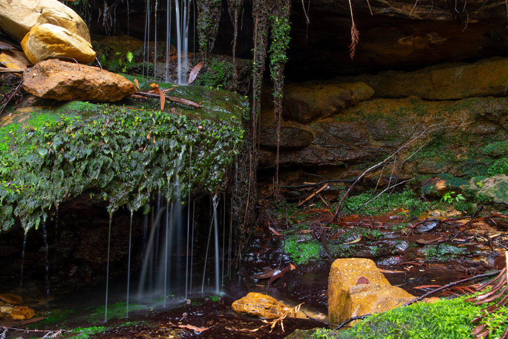
There are quite a few seeps along the track from Siloam Pool to the Lyrebird Dell with water running down the rock faces and the thick mosses growing on them. The forest was cool and shady...a change from the blazing sun and heat. 

It was the end of summer when we visited so the rest of NSW was dry as tinder..in fact we passed through a bush fire on our way to and from Canberra.  It was nice to be in a cool almost naturally air conditioned place if only for a short time. 


Water seep along the Lyrebird Dell Track

There are a couple of caves about 800 meters from the Pool of Siloam. They are closer to rock outcrops than caves but are still interesting to explore. Excavations around these over hangs found 12 000 year old stone fragments from tool making by the indigenous Aboriginal people. They had lived in this area for millennia and only really moved further inland after European settlement. It is easy to see why with the presence of shelter, game, running water and other resources. 


One of the small caves on the Lyrebird Dell Track

Another rock overhang on the Lyrebird Dell Track

Lyrebird Falls are not far past the two small caves and while the falls are not massive it is set in a very idyllic grotto surrounded by bush and with a plunge pool at the base of the falls. It was cool and damp at Lyrebird Falls and we sat on a log here and contemplated the falls for some time. 


Lyrebird Falls, Blue Mountains NP


There is a historic picnic area near the Lyrebird Falls which has been in this location since the 1930's. Back then groups would come on organised outings to the area to enjoy the clean air and cool forest surrounds. It must have been a bit of a journey back then with the primitive vehicles they would have used along what I imagine were rough and punishing roads.

The big cave it sits in was once used by Aboriginals as a place to live and is still considered sacred to them. It is easily the largest of the caves and overhangs along this track and you can see why they would have used it for shelter. It does seem a bit inappropriate to have picnic tables here BUT you cannot judge 1930's Aussies with 21st Century mores...


The picnic area near Lyrebird Dell Falls

From the Lyrebird Dell you continue on the Lyrebird Track for about another 500 meters before finding yourself back up on Lone Pine Avenue. From here you just walk along the road all the way back to Gordon Falls Reserve about another 500 meters away. 

You are back at your start point...

In the bush on the way back to Lone Pine Avenue, Lyrebird Dell Walk

Lone Pine Avenue heading to Gordon Falls Reserve, Leura

There are an ornate set of memorial gates at the entrance to Gordon Falls Reserve with the names of locals killed during the Boer War and WWI. At the time this would have been a very small and sleepy rural town so the fact there are over thirty dead from World War I must have been devastating to the local community. 

You see similar memorials in most small rural New Zealand towns..Akaroa has over twenty names on its memorial arch...probably most of the young men who lived there prior to the Great War. A real waste of potential as all wars are....


Entrance gate at the Gordon Falls Reserve, Leura


From Gordon Falls Reserve you should head by foot or vehicle down to the southern end of Lone Pine Avenue to the Gordon Falls Lookout. This is the only spot in the immediate area with an unobstructed view out to the rest of Blue Mountains National Park. From here you have a good view of Mt Solitary off in the distance, Jamison Valley and the huge cliffs around Leura...


Gordon Falls Outlook, Blue Mountains NP


You can also see the Gordon Falls way down below you...the falls drop from the top of the escarpment down into an amphitheater below and then run into Gordons Creek. It really reminded me of the falls you pass near Coal Creek on the Paparoa Great Walk here in New Zealand. They are a similar height and the cliffs look much the same with that sandstone and limestone...


View down to the Gordon Falls, Blue Mountain NP


I think it would be worthwhile visiting Gordon Falls just after a big storm as I believe the falls would act like a giant storm drain for the surrounding area. I bet they are quite spectacular with a lot of water rushing over them...

Mt Solitary and Jamison Valley from Gordon Falls Lookout

It was interesting to take a walk in the Australian bush...it is very different to New Zealand with a completely different range of tree species and animals. If I manage to make it back over the ditch to NSW and Sydney in the future I will make sure to go up to Katoomba for a couple of days and do some more walking there. 


Access: From Sydney take the Great Western Highway to Katoomba and Leura. At Leura follow Luera Mall and turn left onto Gordon Road. Follow Gordon Road to Lone Pine Avenue. Park at Gordon Falls Reserve or along Lone Pine Avenue and look for the track start.
Track Times: The Lyrebird Round Trip is 1.8 km or around 1.5 hours. Pool of Siloam Walking Track (30 minutes), Lyrebird Dell Walking Track (30 minutes), Lyrebird Dell to Gordon Falls Reserve (20-30 minutes)
Miscellaneous: There is a picnic area, toilets and playground at Gordon Falls Reserve. The track down to the Pool of Siloam is steep and can be muddy and slippery at times. There is a historic picnic area near the Lyrebird Dell. Gordon Falls Lookout is at the southern end of Lone Pine Avenue.