A wee stroll around Quail Island...
I often go for fitness walks along the Port Hills and have often thought it would be fun to re visit Otamahua/Quail Island in the middle of Lyttleton Harbour. The last time I was there was 1984 for a school trip. One day over the summer I thought I have to just do this, so I hopped onto the ferry and went to Quail Island.
Quail Island: access by boat only...
 |
| Quail Island from the top of Mt Herbert 2015 |
 |
| Quail Island as viewed from the Port Hills 2016 |
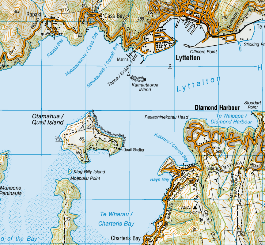
Quail Island is in the southern corner of Lyttleton harbour and has no direct access by land. It is the plug of the extinct Lyttleton volcano and has hosted over the years farming, whaling, animal/human quarantine, military and ship building roles.
 |
| Lyttleton, Diamond Harbour and Otamahua/Quail Island |
The ferry is quite cheap at $15 per child and $30 per adult. No bookings are required you just turn up to the ferry terminus at Lyttleton harbour and pay the people on the ferry. Over the summer the ferry sails at 10.20, 12.20 and 3.30. The trip takes about 10-15 minutes to reach the island.
Please note: there are no potable water sources on the island so make sure you take enough for the duration of your visit.
 |
| Access point for the Quail Island Ferry, Lyttleton Harbour |
 |
| On-board the Blackcat Ferry to Quail Island |
 |
| On-board the BlackCat Ferry to Quail Island |
You get some great view of the harbour from the ferry, you can see out to the Lyttleton Heads and the full expanse of both the Port Hills and Banks Peninsula.
 |
| Lyttleton Harbour from the Blackcat ferry to Quail Island |
 |
| Approaching Quail Island on Lyttleton Harbour |
Arrival at Otamahua/Quail Island
The ferry drops you off at the Quail Island jetty, this is a public jetty so can be used by both the public and government agencies. There is a circuit track right around the perimeter of the island called the Quail Island Track. It is 5.5 km's and takes 2.5 hours to walk around the island.
I took slightly longer as I stopped to visit the highest point of the island Pt. 86, Shipwreck Beach and other historic sites.
 |
| The jetty at Quail Island, note the day shelter in the background |
 |
| Blackcat Quail Island Ferry disembarking |
 |
| The tourist hordes...Quail Island Jetty |
 |
| Lyttleton from the Quail Island jetty |
 |
| DOC sign, Otamahua/Quail Island jetty |
 |
| Start of the Quail Island Circuit track |
 |
| DOC map of Quail Island |
Once on the island you can walk either direction to eventually arrive back at the jetty. I was on the 10.20 ferry and was leaving on the 3.30 pm ferry so I had all day to explore points of interest. I would suggest you do this as it gives you plenty of time to enjoy the experience.
 |
| Quail Island: the old quarantine stables |
 |
| Quail Island: Track to old lighthouse keepers cottage |
 |
| Quail Island: The lighthouse keepers cottage |
There are a lot of interpretive panels scattered around the island which give you a potted history of the island use over the years. There are also panels describing the native fauna and flora as the island is the site of a native forest regeneration programme.
 |
| Interpretative sign on the Quail Island Track |
A new DOC hut in the making...
A bit of exciting news...the old heritage centre on Quail Island is being converted into a standard 10-12 person DOC hut. The work has already started and is due to be completed some time in April/May of 2018.
My understanding is that the hut will go straight on the hut booking system as it is so close to Christchurch but that it will not be able to be booked for a large group. This is great news as it adds a really relaxed first hut option for newbie trampers and families.
 |
| Quail Island: the old heritage centre aka Quail Island Hut |
 |
| Quail Island: information about the conversion to a standard DOC hut |
As you can see DOC is in the process of adding some insulation and bunks to the inside of this old farm house, work has halted for the Christmas break.
The building looks really cool!
 |
| Quail Island: building materials in the new Quail Island Hut |
 |
| Quail Island: hut wardens quarters at new Quail Island Hut |
 |
| Quail Island Hut aka the old heritage centre |
Here is an interesting artefact...a whale bone outside the new hut. There was a small whaling operation on Quail Island back in the 1850's but this was short term as the whale population was quickly decimated.
 |
| Quail Island Hut...and old whale bone |
On the Quail Island Circuit track
Once past the old heritage centre you join the Quail Island Track which skirts the edges of the Island. I walked in a counter clockwise direction so that I could have lunch at the Swimmers Bay picnic area in the early afternoon.
 |
| Lyttleton from the Quail Island Track |
 |
| Quail Island:DOC track sign |
The track is very gentle and easy to follow...it is basically a wide grassy path cut through the long grass that covers the island. There are substantial areas of native planting, when this matures most of the island will be covered with a mix of grass, tussock, bush and dense podocarp forest.
 |
| Quail Island: the Quail Island Track |
 |
| Regenerating native bush on Quail Island |
 |
| Quail Island: area of regenerating native bush |
Wards Homestead was the original site of the first farm on the island, all that is left now are some foundations and an old cast iron Challenger stove.
 |
| Quail Island: Wards Homestead site |
 |
| Challenger stove at the old Wards Homestead site, Quail Island |
As you walk around the island there are some stunning views of the harbour and surrounding hills. It was an overcast day but because it was about 26 degrees Celsius it was very pleasant.
 |
| View towards Lyttleton heads from Quail Island Track |
 |
| Quail Island: volcanic outflow cliffs |
 |
| Quail Island: view of the circuit track around the island |
 |
| Moody view of Lyttleton Harbour from Quail Island |
 |
| The Port Hills from Quail Island |
 |
| Quail Island: the rugged coastline surrounding the island |
 |
| Diamond Harbour, Mt Herbert from the Quail Island Track |
The slight ridge to the right of the photo below is the highest point on the island Pt. 86. There are a number of tracks which reach this point none of which are shown on the topomap for the island.
 |
| Another area of regenerating bush on Quail Island |
I went for a bit of a side trip to Pt. 86 when I passed by one of the access paths. From the top you can see all of Quail Island, plus a 360 degree panoramic view of all of Lyttleton Harbour.
 |
| Quail Island: Highest point on the island- view of Lyttleton |
 |
| Quail Island: Highest point on the island- Governors Bay and Sugarloaf in distance |
 |
| Topomap of Otamahua/Quail Island note Pt. 86 |
 |
| Quail Island: Highest point on the island- view of Moepuku Point |
 |
| Quail Island: Highest point on the island- Moepuku Point and Mt Bradley |
 |
| Quail Island: Highest point on the island- Mt Herbert Massif |
 |
| Quail Island: Highest point on the island- Diamond Harbour |
Two oddities I spotted on my way to Shipwreck Beach were an old World War Two gun emplacement and a tap for the islands irrigation system. The island had awesome views of Lyttleton so I imagine the emplacement was there in case the port was ever invaded. It was probably a relay station for the 8" guns they had on Godley Heads and the smaller 4" ones on Rippa Island
Quail Island has no flowing water so it is very arid. DOC have a system of water tanks and hose connections all across he island to supply water to the regenerating bush. Once the bush is mature it will retain a certain amount of moisture naturally.
 |
| Quail Island: An old WW2 gun emplacement |
 |
| Quail Island: irrigation system for native bush |
The half way point of the Quail Island Track is near Shipwreck Beach.
 |
| Quail Island: Half way point of the circuit track |
 |
| Quail Island: Half way point of the circuit track, Sugarloaf in centre of photo |
Shipwreck Beach is an old graving point where derelict hulks were dumped in days gone by. As a result there are about half a dozen old wrecks there which you can clearly see in the water. Eventually these will corrode, break down and become a part of the beach sand.
 |
| Quail Island: Shipwreck Beach |
 |
| Quail Island: Shipwreck beach- interpretive panel |
 |
| Quail Island: Shipwreck beach- one of the ship hulks this is the Durra |
The people you can just see coming down to the beach in the photo below nearly walked over the bluff in the middle of the photo. There is no official track down to the beach so please take care if you decide to forge your own. For your own safety stay on the tracks as there are some big cliffs/bluffs you could fall off.
 |
| Quail Island: Shipwreck beach- view back up to the circuit track |
 |
| Quail Island: Shipwreck beach- another of the hulks, this is the Mullogh |
 |
| Jon at Shipwreck Beach, Quail Island |
Officially, DOC do not want you to walk down to the beach as it is a historic site. However there are a number of paths down the hills to the beach...if you visit (like I did) stay well away from the hulks.
Do not stand on the hulls like the people in the photo below!
 |
| Quail Island: Shipwreck beach- the indistinct track down to the beach |
I continued on from Shipwreck Beach and followed the track around the rest of the island to Swimmers Beach where I stopped for some lunch and a lay in the sun for about an hour and a half.
 |
| Quail Island: on the track to Swimmers Beach |
 |
| Moepuku point...closest point between the mainland and Quail Island |
As I moved around to the southern side of the island I encountered a lot of Quail running across the track and perched in the trees and bushes. These are not the native quail which originally inhabited the island but exotic quail. The native Quail quickly disappeared after settlement probably destroyed by introduced rats, mice and domestic cats.
 |
| Quail Island:young Quail chicks on the circuit track |
The quail are really tame, I had one male approach to within 2 metres of me. I imagine they often get fed by the people who visit the island.
 |
| Quail Island:view of a Quail from my rest spot on the track |
 |
| Quail Island:one of the male Quail who inhabit the island |
 |
| Quail Island:female Quail on branch of native bush |
Eventually you reach Skiers/Swimmers beaches which is the end of the circuit track. I had some lunch and lay out of the sun in the warm air for a while until it was time to head to the jetty for the journey home. There is a nice picnic area at Swimmers beach with picnic tables, toilets and shade. It is only a 10 minute walk to the Quail Island jetty from this beach.
 |
| Quail Island:heading down to Skiers Beach |
 |
| Quail Island: nice benched track near Skiers beach |
 |
| Quail Island:Skiers Beach- the tide is out...mudflats! |
 |
| Quail Island: a stone wall built by early convict labourers |
At one stage Quail Island was a leper colony: it only ever had a handful of inhabitants but was a total necessity as leprosy is highly contagious and was incurable up to the advent of penicillin. There are still some foundations left from the huts the lepers lived in near Skiers Beach. There is also a recreation of a leper cottage which is worth a visit.
 |
| Site of the Quarantine station on Quail Island |
 |
| Old foundations for the quarantine barracks on Quail Island |
Swimmers Beach picnic area
There are a pair of beaches at the end of the track, both are rocky and muddy but there are mature shade trees and picnic tables to sit at while having your lunch. I saw a number of people walking/swimming on the beach but they got very muddy with the tide out so bear this in mind.
 |
| Quail Island: Swimmers Beach picnic area- note rope swing |
The small building you can see in the centre of the photo below is the recreation of the old leper cottage I mentioned previously.there is a short track to this hut from near the handmade stone wall...
 |
| Quail Island: Skiers Beach from Swimmers Beach, note recreation of leper cottage |
 |
| Low tide at Swimmers Beach |
 |
| Quail Island: Swimmers beach at low tide |
 |
| Quail Island: Swimmers beach, old stock jetty and new heritage centre |
Swimmers beach is highly tidal, when the tide is in the water reaches almost to the top of the seawall, but when out there are extensive expanses of mudflats/shell banks to explore.
I saw three idiots in boats come shooting into the bay only to suddenly come to a jarring halt as they beached themselves on one of the many sand banks. It is really shallow at low tide!
 |
| Quail Island: Pied Oyster catchers (?) looking for some dinner at Swimmers beach |
 |
| The Mt Herbert/Mt Bradley Massif from Quail Island |
I ate my lunch at one of the picnic tables before finding a nice spot out of the wind to sit in the sun for about an hour. As you can see I had my usual pate, crackers and drink with a nougat bar for dessert.
I loves me some of that canned Hanaff French pate...good quality and delicious!
 |
| My tasty tramping lunch: pate, crackers, nougat bar and isotonic drink |
Here is a shot of one of my previous tramping locations, Mt Bradley on Banks Peninsula. Mt Bradley is the third highest point on Banks Peninsula at around 900 metres a.s.l. All of the land below the top of the mountain is part of the Orton Bradley Estate.
 |
| Close up of the Mt Bradley tablelands from Quail Island |
 |
| Mt Herbert as viewed from Swimmers Beach |
With the conversion of the old heritage centre to a DOC hut, the Trust which governs the island are shifting the information centre to an old immigrant barracks down at Swimmers Beach.
They have already moved some of the displays, my understanding is that the building is due for a refurbishment some time over the next year. This is a historic building from the 1850's so I imagine very little can be changed of the original structure.
 |
| Inside the new Quail Island Heritage Centre |
 |
| Relief model in the new Quail Island Heritage Centre |
 |
| Quail Island:Interpretative panel in the Quail Island heritage centre |
 |
| Map of historic sites and tracks on Quail Island |
 |
| Heading along Swimmers beach to the ferry jetty |
The toilets at Swimmers Beach are at the Diamond Harbour end of the new heritage centre building.
 |
| DOC boat/gear shed on Quail Island |
Later in the afternoon I moved to a nice bench seat down at the far end of Swimmers Beach next to the DOC boat shed. It is a nice spot with shade and well protected from the wind.
 |
| Jon near the Quail Island DOC boat shed |
From Swimmers Beach it is a short 10 minute walk back to the main jetty passing the old stock wharf and the start of the circuit track en-route.
 |
| Heading towards the old stock jetty, Quail Island |
 |
| Quail Island: the old stock jetty |
 |
| Quail Island:close-up of the dilapidated stock jetty |
 |
| Quail Island: on the track back to the jetty from Swimmers Beach |
 |
| The Quail Island boat jetty |
There is a basic but nice day shelter just up the hill from the jetty, it would provide welcome shelter from the elements if the weather turned bad while you were on the island. There are benches inside with a clear view of the jetty so you would be sure to see the ferry arriving.
 |
| Quail Island day shelter- exterior |
 |
| Inside the Quail Island day shelter...plenty of seating! |
 |
| Quail Island day shelter |
You would be well protected from the elements in the shelter regardless of the wind direction as it is surrounded by mature pine trees.
 |
| Quail Island: The jetty from the day shelter |
This was my first tramp for several months and it was a very pleasant experience. The track around the island is easy to follow and never too strenuous. It took me about three hours to circumnavigate the island but that was walking very slowly and going off on tangents to visit points of interest.
I was on the Island from about 10.40 till 3.30 in the afternoon, but if you ran around the island or walked very quickly you could complete the circuit in less than an hour and a half. I totally recommend a visit to the island take your kids and a picnic lunch...go for a stroll and sit on Swimmers beach and enjoy the view.
Cheers.
Access: Water taxi from Lyttleton, the trip takes 15 minutes ($15 child, $30 adult)
Track Times: 5.5 km's or 2-3 hours from jetty to jetty
Hut Details: Quail Island Hut: (building Jan 2018) it will have 10-12 bunks, wood burner, water tank, wood
shed, toilets
Miscellaneous:
The hut when finished will be on the DOC booking system, must be booked for overnight visit.There are presently no potable water sources on the island so take plenty of water