How to tramp in the wet weather and still have fun...
Despite the current Covid 19 situation we need to start thinking beyond the lock down period and start planning our outdoor adventures for when we are able to tramp once again. This is looking more likely the lower down the Covid levels we move.
 |
| Pororari River Track at Punakaiki...possibly my first post lock down tramp!!! |
 |
| Heavy rain sets in at Lake Daniell, Lewis Pass Scenic Reserve |
With many more of us likely to be out tramping over winter (because we missed the summer season due to Covid 19...) we need to think about how we can tramp in the rain and still enjoy ourselves.
Your attitude to rain counts...
Winter/Spring tramping means getting wet (...and also cold..) so we need to be mentally prepared for the weather we receive. There are many positives to walking in rain...it is cooler than on a hot day, drinking water is easier to find, there are less people/less bugs and I find a forest comes alive during rain in a way it will not when it is dry. Everything is sparkling, clean and fresh after rain.
I really enjoy the look, feel & smell of a wet forest and the squelch of wet ground underfoot. If you have ever tramped in rain you will know what I mean
I really enjoy the look, feel & smell of a wet forest and the squelch of wet ground underfoot. If you have ever tramped in rain you will know what I mean
 |
| Wet conditions on the Routeburn Track in December 2019... |
There is no getting around the fact that if you are walking in the rain you are going to get wet!! Rain may fall on you from both the sky and from any overhanging trees...if it is raining the track willhave puddles so your feet will also get wet. If you are wearing your wet weather gear perspiration is going to wet you from inside your rain layers.
 |
| Wet track conditions on the way to Lake Daniells, Lewis Pass |
You have to see the positives in this and maintain a positive attitude to being wet if you want your tramp to be a success. As a person once said "...you can be cold, wet and miserable or you can just be cold and wet..." I would practice being out in the rain by doing some short walks in rain close to home...get to see what it feels like to be out in rain and that it can be a positive experience.
 |
| It may be wet but it is also beautiful... |
What you have to do is adapt to the wetness and try to minimise its impact on the enjoyment of your tramping trip.
Tramping clothing for wet conditions
Tramping in the rain requires specific clothing....rain layers, gaiters and extra warm clothing...you will need all of these if you want to be comfortable while walking in cold and wet weather.
There are some things you should never wear in rain...jeans, linen/cotton t-shirts and cotton socks. All of these take a long time to dry and can sap heat from your body as they dry. Wearing wet cotton clothing can potentially cause chaffing, chills, cold strain injuries and possibly hypothermia in extreme cases.
 |
| Walking in the rain on the Lakehead Track, Nelson Lakes NP |
There are some things you should never wear in rain...jeans, linen/cotton t-shirts and cotton socks. All of these take a long time to dry and can sap heat from your body as they dry. Wearing wet cotton clothing can potentially cause chaffing, chills, cold strain injuries and possibly hypothermia in extreme cases.
 |
| Jeans are not recommended for tramping... |
I usually tramp in shorts with knee length gaiters so most of my body is covered...only my knees are exposed. This is a personal preference as I find pants too constricting when I am out in the backcountry. If you must wear pants make sure they are a quick drying, durable synthetic type preferably with zip off legs. These can often be cleaned and dried overnight ready for the next days travel.
 |
| ...wear shorts or synthetic hiking pants instead!!! |
 |
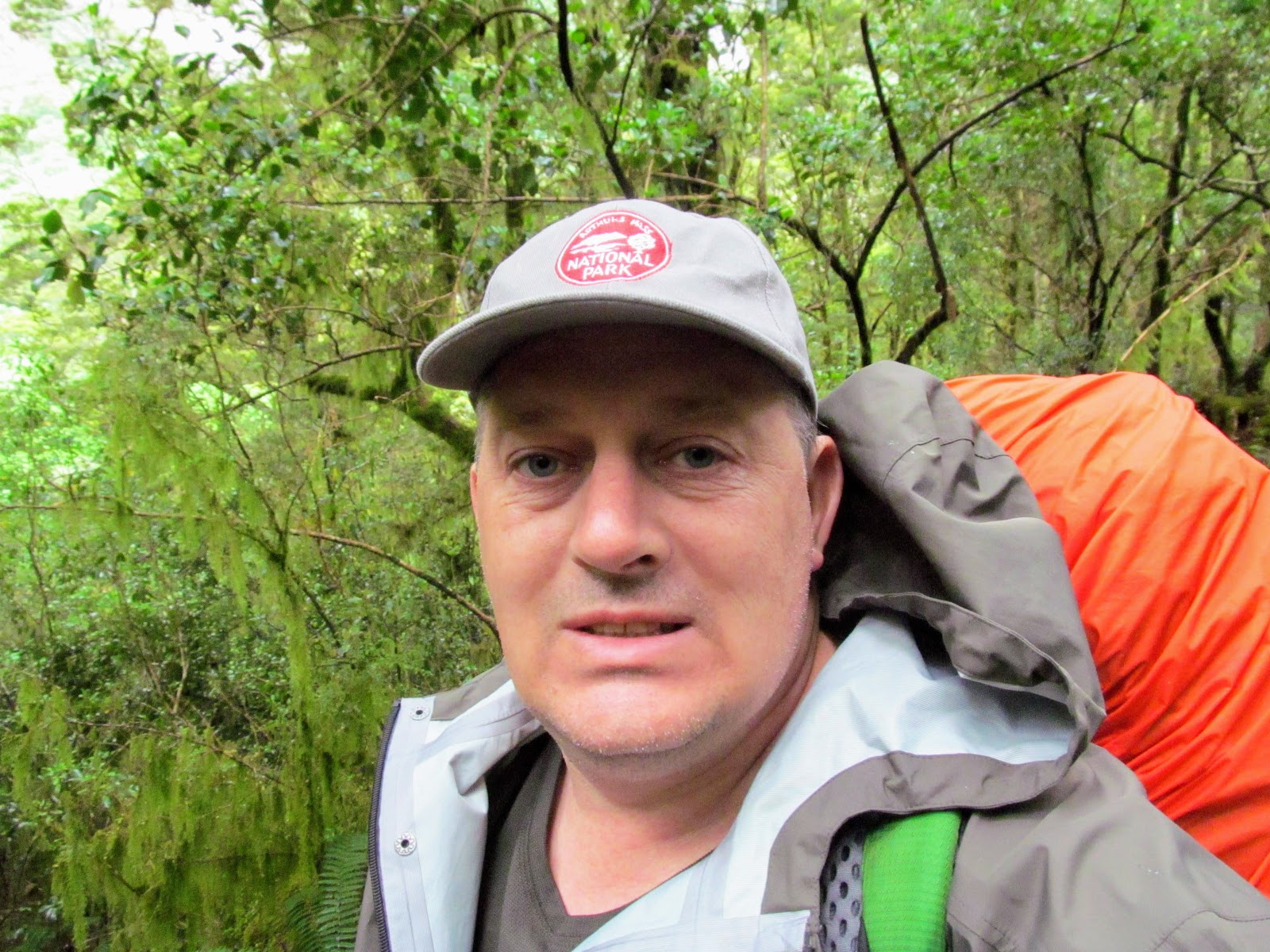
| Jon tramps in shorts, a synthetic shirt and long gaiters... |
It is essential (especially in wet New Zealand conditions) that you have a sturdy, fit for purpose 2.5-3 layer rain jacket with an adjustable peaked hood and rain proof zips. The large hood is large enough to go over a hat or head covering. Rain proof zips stop water ingress in heavy rain and opening them allows you to regulate your body temperature. Try to find a jacket with a waterproof flap over any zips for added protection.
The jacket should be slightly loose to allow mid layers to be worn under it and to allow a degree of air flow. I prefer a classic Kiwi style down to the waist model to ensure any rain runs off the end of my lower garments.
 |
| Stony Creek jacket...waterproof zip and a rain flap... |
The jacket should be slightly loose to allow mid layers to be worn under it and to allow a degree of air flow. I prefer a classic Kiwi style down to the waist model to ensure any rain runs off the end of my lower garments.
 |
| My wet weather gear: long jacket, wet weather pants and Goretex mittens |
I normally tramp in shorts but wind+rain is your enemy when dressed like this. A stiff breeze will quickly cool you to a dangerous level if you do not cover your legs in wet windy weather which is common on ridges and at higher elevations. If you are tramping along ridge-lines or on the tops it is essential that you carry a pair of wet weather trousers. They help to limit wind caused heat loss through your legs.
Rain pants are also useful if you are in a wide open valley (think South Island tussock covered-i.e the St James/Waimakiriri/Godley/Ahuriri/Greenstone etc.) with little vegetation as they form natural conduits for strong wind.
 |
| Wet and windy conditions in the Tararua Ranges.... |
Make sure they are durable..I have literally had a pair of cheap over-trousers blown to shreds by strong winds when out tramping on the tops...
If you are spending most of your time in the bush or on forested valley floors you can normally go without rain trousers...wind is not such a factor here. I would still use a commercial rain kilt or modified rubbish bag kilt to keep the shorts dry
 |
| The remains of my wet weather pants after stormy tops travel...munted!!! |
If you are spending most of your time in the bush or on forested valley floors you can normally go without rain trousers...wind is not such a factor here. I would still use a commercial rain kilt or modified rubbish bag kilt to keep the shorts dry
 |
| Mixed group of trampers wearing various rain gear.... |
Your feet will get wet from rain running down your legs and from the wet track. Boots are better than shoes in rain and a pair of gaiters can assist with keeping your feet dry. Make sure you have clean, dry socks to put on once you reach your destination and reserve them for this purpose only. Be prepared to have wet feet and plan accordingly.
 |
| Boots & gaiters are excellent in wet, muddy conditions... |
Make sure you always carry your wet weather gear whenever you go tramping because our weather can dramatically change in just a few hours. It may increase the weight of your pack but it can easily be the difference between life and death.
Other gear you will need to tramp in the rain
There is some other gear you need for tramping in the rain...some is used to keep you dry and some is to keep your gear dry. Here is a list of rain equipment I carry;
Good wet weather gear...both jacket and over trousers
Knee length gaiters to stop water running into your footwear
Polypropylene gloves to keep my hands warm
Gortex over-mittens to keep my gloved hands dry
A water proof map cover...I use a ziplock bag
A water proof pack cover and a plastic pack liner
A separate waterproof cover for your sleeping bag
A standard truckers/baller cap
 |
| A ball cap keeps rain off you face and provides sun protection.... |
It is important to keep the contents of your pack dry so put a plastic liner bag inside your pack and use a pack cover to minimise water getting inside. Your pack contents are your lifeline...keep them dry at all times. It is especially important to protect your sleeping bag...wrap it in its own plastic bag or keep it in a waterproof cover. Make sure you have a change of clothes if you are on an overnight trip. It is warmer and more comfortable to have something dry to wear at the end of a wet day.
 |
| A plastic pack liner will keep your gear dry... |
You will need to read your map so place it in some form of waterproof cover so it can still be used in the rain. It can also be useful to carry a waterproof pack cover...commercial version or a plastic rubbish bag can suffice if it is well secured. While they will not keep your pack completely dry they do decrease the amount of rain water your pack will absorb.
Why carry an extra kilo of rain soaked pack if you do not need to?
Why carry an extra kilo of rain soaked pack if you do not need to?
 |
| ...and a pack cover will help keep your pack drier.... |
A baseball cap is really useful in rain...it keeps the rain out of your eyes with its wide brim and keeps the wide hood of your jacket from falling over your eyes. If it is raining but warm a wide brim hat is better as you will probably want your hood down for better ventilation.
Check the weather before you go
This really needs little explanation...always check the weather conditions before you go out on any walk/tramp/MTB ride. There are many sites and places to find up to date weather information for your intended tramping route...my go to is Met Service for both general and the Ventusky website more specific information on wind , rain and snow.
 |
| The Met Service web-page is your best place for weather information... |
 |
| Ventusky is awesome for in depth weather predictions... |
During late Autumn to early Spring it is fine to head outdoors in fine and moderate weather conditions but you need to know if any severe weather is expected in your intended location. Because of our temperate oceanic weather patterns we can have extreme cold/wet/windy conditions right through the year.
Even with the best skills and gear no-one should be attempting a tramp in extreme weather...it is just too dangerous. The margin between success and failure is knife thin when bad weather threatens. Save yourself, your family and SAR a lot of grief by only tramping to your skill limits over the winter months.
Even with the best skills and gear no-one should be attempting a tramp in extreme weather...it is just too dangerous. The margin between success and failure is knife thin when bad weather threatens. Save yourself, your family and SAR a lot of grief by only tramping to your skill limits over the winter months.
 |
| Early summer snow fall in the central South Island |
Ensure that you know the expected weather conditions before you leave home!!!
Regulate your body temperature
Just because it is raining does not mean that you must stay indoors...you simply need to wear the right clothing layers...especially a good breathable rain shell. These are always one of the most expensive items a tramper requires and usually come in one of a variety of technical synthetic materials.
Remember that no material made to stop you getting wet is completely breathable...condensation will build up making you wet from the inside. Even with fantastic breathable fabrics like Goretex, Omni Dry and E-Vent you are still going to get hot if you are exerting yourself...walking up hills, walking long distances or if you are carrying a heavy load...
 |
| Goretex is one of many three layer materials... |
| The various layers in a breathable material....this is Gortex |
Remember that no material made to stop you getting wet is completely breathable...condensation will build up making you wet from the inside. Even with fantastic breathable fabrics like Goretex, Omni Dry and E-Vent you are still going to get hot if you are exerting yourself...walking up hills, walking long distances or if you are carrying a heavy load...
 |
| Full wet weather gear on a rainy tramp on Te Ara Pataka, Banks Peninsula |
To minimise overheating while wearing a rain jacket you need to pay close attention to your layering..thinner moisture absorbing base layers with a thin insulating layer only if it is very cold. This is topped by your wet weather or shell layer. Take layers on and off as required to regulate body temperature, too cold- add a layer...too hot- take a layer off.. Open zips at the collar, front, sleeves and arm pits if you have them to vent heat...or completely remove the rain layer if possible.
Give that body heat a means of escape....
Give that body heat a means of escape....
 |
| Open zips and hood down for best ventilation... |
Hydrate well and make sure you are eating food to both maintain energy and keep your body producing heat. It is especially important to keep drinking when you are walking in the rain as the natural inclination is to drink less. I have a drink every time I stop...this soon becomes a unconscious habit.
 |
| Rest stop on the Rakuira Track with intermittent drizzle... |
Make sure you still have short regular breaks to rest your body but limit the amount of time at a halt to minimise getting too cold. Take shelter under trees, caves or a man made structure while resting if you can.
Hypothermia: the silent killer!!!
Hypothermia is one of the most dangerous health concerns when tramping...it is an over cooling of the body's core temperature which can lead to lethargy, irrational thought patterns, physical collapse and ultimately death. It is not as prevalent as it used to be due to advances in tramping clothing BUT there are still several deaths a year from hypothermia.
It can happen to anyone..I have personally had very mild hypothermia a couple of times over the years...you often don't realise you have hypothermia when it is happening to you. This is because one of the symptoms is dis-associative behavior i.e. you are acting out of character but do not understand that you are.
On my recent tramp on the Routeburn Track last December we had several people in the mid stages of hypothermia at Howdon Hut. It was perfect weather for it...cold, windy, heavy rain and people woefully ill prepared to be out in those conditions.
Luckily some of us old timer trampers recognized the symptoms and took action to assist the people affected. I had my PLB out at one stage as one woman was looking really unwell but she recovered with warm clothes, some food and a couple of hours of rest.
 |
| Hypothermia is a silent killer here in New Zealand... |
It can happen to anyone..I have personally had very mild hypothermia a couple of times over the years...you often don't realise you have hypothermia when it is happening to you. This is because one of the symptoms is dis-associative behavior i.e. you are acting out of character but do not understand that you are.
 |
| Cold, wet and windy conditions contribute to hypothermia... |
 |
| Awful weather on the Routeburn Track in December 2019... |
Luckily some of us old timer trampers recognized the symptoms and took action to assist the people affected. I had my PLB out at one stage as one woman was looking really unwell but she recovered with warm clothes, some food and a couple of hours of rest.
 |
| Wet conditions I encountered in the Greenstone Valley in December 2019 |
You need to know the signs of hypothermia and how to deal with it effectively both for your sake and for those around you. There is some information about hypothermia in every Hut Intentions book...this is a good start but read some general tramping manuals or books on outdoor medicine, look for authoritative online information and keep yourself and your tramping buddies safe.
Terrain dangers in the rain
There are some specific terrain features to watch in wet conditions these are camping locations, river crossings, slip hazards and avalanches.
Camp selection: Do not ever camp in a slot canyon, arroyo, wadi or steep narrow ravine. All of these are susceptible to flash flooding which can be extremely dangerous. It may not be raining where you are but 10 kilometers away it is teeming down and a flood can swiftly and easily over whelm you. I would also never camp close to a river unless I was on a raised bank or well above the water.
 |
| Narrow canyons are dangerous places in rain....flash floods can occur!!! |
River crossings: Crossing a river is dangerous at the best of times but especially dangerous in wet condition's. It doesn't take much for a river to flood especially here in New Zealand. Do not attempt to cross a flooded river...if it is running faster than walking pace, cloudy, has bow waves in front of rocks, you cannot see the bottom or is carrying debris DO NOT ENTER IT!!! Find shelter and wait for it to subside.
 |
| A flooded and dangerous Alfred River, Lewis Pass Scenic Reserve |
Slip hazards: Hillsides are prone to slippage in heavy rain...water permeates the top soil and loosens the bond between it and the sub strata. Slips can be small or large but all of them are dangerous. A good example are the recent slips in Fiordland as a result of heavy rain in February 2020. Several tracks were destroyed by slips/floods and Howdon Hut was damaged by a large slip. The government have recently allocated $13 million to fix the damage in the area...
There is not much you can do about new slips but stay well clear of any established slip zone in heavy rain as the water can dislodge loose material.
There is not much you can do about new slips but stay well clear of any established slip zone in heavy rain as the water can dislodge loose material.
 |
| Howdon Hut, Fiordland...hit by a massive slip in February 2020 |
Avalanches: Avalanches are more likely to occur in heavy rain as the water softens the snow pack and lubricates its forward motion. Stay clear of known avalanche zones during and after heavy rain and be especially careful if crossing avalanche chutes when it is raining.
 |
| Take care around avalanche zones after rain and then snow.... |
Do not enter any area known for avalanches if heavy rain has been followed by heavy snow as the avalanche risk will be much higher.
Hut/Tent life in the wet
Under the Current Covid 19 Level 2 rules all of the DOC huts are restricted to 10 people or less regardless of their size. This means you are going to be doing a lot of tenting trips for the foreseeable future. Rain can making tenting challenging but it is still totally possible...you simply need to practice your camping skills so that if you have to spend time in a tent you will still be comfortable.
 |
| Inside my tent on the Queen Charlotte Track in 2016 |
Practice so you can quickly erect your tent under all weather condition's...I set mine up every so often to make sure I am familiar with the process. Look for a good tent site on either a slight mound or gently sloping ground for best drainage. Do not set a tent in a natural bowl or depression as this will often fill with water in heavy rain.
Always check for over head dangers...so called "widow makers" ...loose branches that may fall on your tent in windy conditions. These may dislodge in the night and injure you. Try to pick a location with protection from the wind perhaps behind a handy boulder, earth berm or group of bushes.
 |
| A decent tent site....slightly sloping, protected from wind and an absence of overhead dangers... |
Always check for over head dangers...so called "widow makers" ...loose branches that may fall on your tent in windy conditions. These may dislodge in the night and injure you. Try to pick a location with protection from the wind perhaps behind a handy boulder, earth berm or group of bushes.
 |
| Another good tent site, Bay of Many Coves, Queen Charlotte Track |
If you are lucky you will have a cooking shelter at your campsite...these are great as they stop you from getting cold and wet while preparing meals. You will often find this type of shelter on DOC Great Walks, private trails and at commercial campgrounds.
 |
| Camp shelters make meal preparation more pleasant...Moari Bay campsite, Rakuira |
If you are buying a new tent look for one that can be pitched outer first...the tent fly is pitched and then you attach the inner. These types will minimise how wet your inner tent gets during erection but always pack a sponge or bandanna to wipe up any wet patches after you have pitched your tent. Try to buy a tent with a large vestibule so you can leave all your wet gear outside...this will minimise condensation inside.
 |
| Store wet gear in the tent vestibule..... |
Huts are much nicer in rain as you are indoors and often have a fire to dry your gear and warm yourself. Good etiquette is to leave all wet gear outside- boots, gaiters, pack covers and rain wear. Do not leave it outside in Kea country as they love to shred all of these things. Make space for extra people in the hut if it is raining, use firewood sparingly and if possible replace all the firewood you use so the next people have dry wood when they arrive.
 |
| My wet gear in the veranda of Lakehead Hut, Nelson Lakes NP |
 |
| Nothing like a dry, warm hut.....a good book, fire ablaze and brew to hand!!! |
Finally I would just like to reiterate that having a positive attitude can make all the difference to your experience. Hey...it might not be primo conditions for tramping BUT you could always be at work.
Remember ANY day tramping is better than sitting at your desk for 8 hours.....
Remember ANY day tramping is better than sitting at your desk for 8 hours.....