On the path of the Canterbury pioneers....
This was my last tramp for 2019...a fitting final walk on the Port Hills from Heathcote Valley to Lyttelton using the Bridal Path. The historic Bridal Path was the track used by the early pioneer settlers to get from Lyttelton Harbour to their new home in Christchurch.
 |
| Christchurch Gondola Terminal, Heathcote Valley |
Karen had three days off after Christmas Day so we were looking for something to get us outside walking after the excesses of Christmas Day. We rode the Gondola up to the terminus on Mt Cavendish and then walked down to Lyttelton on the Bridal Path. Really this is all training for our trip down to Stewart Island/Rakuria in late January when we are going to tramp the Rakuria Great Walk.
 |
| View of Heathcote and the Canterbury Plains from the Gondola, Port Hills |
 |
| Port of Lyttelton and Banks Peninsula from the Bridal Path |
We were not alone on this tracks...many other people were taking the opportunity offered by the fine weather to get out and about so there were tourists, walkers, runners, MTB riders and trampers out and about enjoying the sunshine.
 |
| Norwich Street in the Port of Lyttelton |
From Lyttelton we caught the No. 28 bus back to the car through the Lyttelton road tunnel in effect making this a circuit.
Heathcote Valley to the Upper Gondola Terminus
It was too hot to walk right over the Bridle Path so we rode the Gondola to the top terminus and then walked down the Crater Rim Walkway to the apex of the Bridle Path. The Gondola had been closed for the previous three days so it was super busy with throngs of tourists.
 |
| Passengers enter the gondola cars, Heathcote Valley |
Karen and I have an annual pass which gives you unlimited rides on both the Christchurch tram and gondola for $90 dollars. A one time adult fare for the gondola is $45 so this is an excellent deal. So far we have used them three times so we have already made our money back on the cost.....
 |
| Map: Heathcote Valley to Lyttelton via the Gondola and Bridal Path |
It was a slightly overcast day but still 25 degrees so it was a perfect day to be out enjoying the joys of walking on the Port Hills. As I have said previously we are incredibly lucky to have the Port Hills on our door offering a wealth of walking, running and riding tracks for people to use. It is one of the things that make Christchurch such a wonderful place to live.
 |
| The Gondola Terminal in Heathcote Valley |
The Port Hills have started to dry out as is customary at this time of the year...given our history of fires on the hills we can but hope to avoid the fire devastation currently the norm over in Australia.
 |
| On the Gondola heading for the Mt Cavendish Terminus |
 |
| Karen in the Gondola Car, Mt Cavendish |
 |
| Heathcote Valley, Port Hills and the Canterbury Plains |
There are superlative views of the Canterbury Plains from on the Gondola and on the day it was clear enough to see right out to the Southern Alps and right along Pegasus Bay to Kaikoura.
 |
| The Gondola car climbs to the top of Mt Cavendish |
 |
| Rock outcrops as seen from the gondola, Port hills |
 |
| Summit Road and view to Birdlings Flat from the Gondola |
We arrived at the Gondola around lunchtime so we stopped for a bite to eat and a cleansing beverage. The cafe at the terminus sells Kronenbourg (Vitamin K.....) which is my favorite French beer so of course we had to partake. They have a wide and delicious selection of drinks, meals, cabinet food and snacks so have a look if you are visiting.
Afterwards we went for a walk around the terminus building before descending to the ground floor and the door to the Crater Rim Walkway which starts right from the terminus building. Below are some photos from the terminus which show just how good the views are from the Gondola...it is well worth the ticket price to see this view for yourself.
 |
| Looking at Mt Pleasant from the Gondola terminus |
 |
| Canterbury Plains from the Gondola Terminus |
 |
| View of Pegasus Bay from the Gondola Terminus |
 |
| Viewing platform around the Christchurch Gondola terminus |
 |
| View right out to Kaikoura from the Gondola Terminus |
 |
| Port of Lyttelton and Quail Island from the Gondola Terminus |
We started down the track heading in the direction of the Pioneer Women's Memorial at the apex of the Bridal Path between Heathcote and Lyttelton.
The Gondola to the Summit Road
As I said the Crater Rim Walkway starts right outside the door of the Gondola terminus and walkers can follow it from this point right out to Gebbies Pass or out to the coast around Godley Head, Taylor's Mistake & Sumner.
 |
| Start of the Crater Rim Walkway at Gondola Terminus |
 |
| Sign for the Crater Rim Walkway, Port Hills Christchurch |
 |
| Karen & the Cavendish Bluffs from near the Gondola, Port Hills |
 |
| Christchurch Gondola Terminus, Mt Cavendish |
The Crater Rim Walkway is also part of the Christchurch 360 Track which I have been walking for the last couple of years. This is a 120 km track which encircles the outer areas of Christchurch and can be walked, run and cycled as you see fit.
 |
| On the Crater Rim Walkway, Port Hills |
I am almost finished the track...I only have the section between Godley Head and Sumner and from Spencer Park to the Waimakiriri to go. It has been a multi year project and I am pleased it is finally coming to a close. Have a look on this site for some of the
posts about Christchurch 360 sections I have completed....
 |
| Sign for the Christchurch 360 Track part of the Crater Rim Walkway |
Once on the Crater Rim Walkway we set off for the Memorial...it is roughly two kilometers from the Gondola Terminus to the Memorial along a winding rocky path. There are superb views from along this section of Lyttelton, the Canterbury Plains, the area around Head of the Bays and over to Mt Herbert and Banks Peninsula.
 |
| Crater Rim Walkway : on the way to the Bridal Path |
 |
| Mt Pleasant bluffs from the Crater Rim Walkway |
The track quality is good...mostly easy to follow and well marked but there are some rough areas and steep sections to be prepared. We passed many walkers and runners who had the same idea as us and were out for an afternoon constitutional while the weather was still fine.
 |
| Lyttelton and Purau Bay, Crater Rim Walkway |
 |
| A Crater Rim Walkway trail marker |
 |
| Summit Road heading towards the Bridal Path |
 |
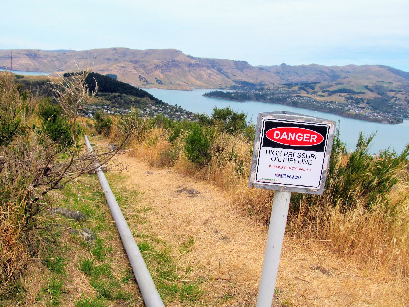
| The LPG pipeline across the Port Hills to Lyttelton |
 |
| Mt Cavendish and the Gondola Terminus from near the Bridal Path |
After about 30 minutes walking the Pioneer Woman's Memorial comes into view...it takes the form of a open-sided shelter right on the apex of the Bridal Path as it crosses the Summit Road. In colonial times this was the only land access to Christchurch from Lyttelton Harbor so every new settler would have walked over here at some stage.
It must have been hard work carrying all your possessions as well as herding your 13 children and 5 servants while your men folk stand around talking trash and smoking their pipes...those hardy pioneer women deserve to be memorialised!!!
 |
| Pioneer Women's Memorial on the Bridal Path apex |
 |
| The Pioneer Women's Memorial, Bridal Path, Port Hills |
There is a plaque inside which tells you what the shelter was meant to commemorate as well as seating for about six people. It is a good spot to get out of the wind and sun for a water/snack break and this is what we did.
 |
| View of Pegasus Bay from the Pioneer Women's Memorial, Bridal Path |
 |
| Plaque in the Pioneers Women's Memorial, Bridal Path |
 |
| View of Lyttelton from the Pioneer Women's Memorial, Bridal Path |
We sat down and had a rest before continuing on our way down the Lyttelton side of the Bridal Path.
From the Summit Road to Lyttelton
We didn't stay too long at the Memorial as it was starting to get windy and there was a bit of a chill in the air. The start of the Lyttelton portion of the Bridal Path starts right next to the Memorial and takes another 30-40 minutes to walk down to the bus stop on Norwich Street.
 |
| Lyttelton & Mt Herbert from the Bridal Path, Port Hills |
 |
| Bridal Path, Lyttelton side, Port Hills |
There are a series of old machine gun posts along the track...these were built back in thew 1940's when the threat of invasion by the Japanese Empire was high. The Port Hills are pepper potted with these type of defense works...they would have caused problems if the Japanese had ever invaded. Given the lack of military manpower and the wide open nature of Pegasus Bay the Japanese could have landed without opposition anywhere along the coast so it was a bit of a waste of time really....
 |
| Old pill box on the Bridal Path, Lyttlton side |
 |
| Another pilbox on the Bridal Path, Lyttelton side |
 |
| Interior of the pill box on the Bridal Path, Lyttelton side |
The track down to Lyttelton is a lot nicer than the Heathcote side of the Bridal Path...it is just as steep in places but the track is better maintained and it is not covered with that deadly small round gravel they use on the other side of the hills.
 |
| Bridal Path, Lyttelton side...heading for Lyttelton |
There are great views of Lyttelton Harbour from up here...you can see all the way from the ocean at the mouth of the harbour clear to the head of the harbor....there are photo opportunities every where you look....
 |
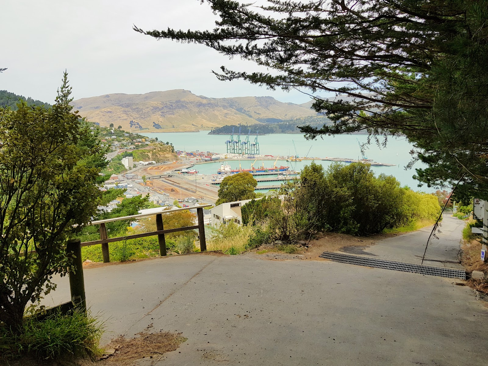
| Lyttelton oil terminus from the Bridal Path, Lyttelton side |
 |
| Port of Lyttelton from the Bridal Path, Lytelton side |
As you can see the track slowly winds down a ridge-line from the Apex to Bridal Path Road at the end of this section of track. It jumps from side to side of the ridge to take best advantage of the terrain as it descends. Make sure you have a hat and sun screen because there is absolutely zero cover from the sun except for a small stand of trees right near the Lyttelton end of the track.
 |
| Steep gravel track, Bridal Path, Lyttelton side |
 |
| View back to apex of Bridal Path, from the Lytelton side |
 |
| Drainage ditch on the Bridal Path, Lyttelton side |
 |
| The Bridal Path, Lyttelton side follows a ridge down to the port |
There are a number of seats and benches along the track.....Karen and I stopped at a particularly nice one half way down the Lyttelton side of the Bridal Path. This one was made of stone and has an excellent view down onto the Port of Lyttelton, Mt Herbert and Purau Bay on the opposite side of the harbor.
 |
| Memorial seat on the Bridal Path, Lyttelton side |
 |
| Great views of Lyttelton...Bridal Path, Lyttelton side |
At various places along the track there are good views up to the Mt Cavendish bluffs and the Gondola terminus propped up on the crest of the Port Hills. The valley under the terminus is a QEII covenanted area of bush and is slowly regenerating with native trees. This is just one of many private and public reserves along the Port Hills which are helping to restore the bush cover that once graced these hills.
 |
| Gondola terminus & bush seen from the Bridal Path, Lyttelton side |
 |
| View back to apex of the Bridal Path, Lyttelton side |
We slowly descended to the end of the track along the gradually improving surface eventually hitting the only shade on this side of the track...a stand of pines and Macrocarpa trees along the bottom. You arrive at last at the end of the gravel track and the start/end point on Bridal Path Road in Lyttelton.
 |
| Nearly at the end of the Bridal Path, Lyttelton side |
 |
| Bridal Path, Lyttelton side....the only shade!!! |
 |
| Start/End of the Bridal Path, Lyttelton side |
 |
| Bridal Path, Lyttelton side...rock fall warning |
There are a number of track markers and some information about the Bridal Path at the end of the track. There is also a memorial to commemorate the 150th anniversary of the arrival of the first settler ships to Lyttelton. The memorial is one of the original piles from the first wharf built at Lyttelton and has a plaque attached explaining its significance.
 |
| Centennial memorial next to the Bridal Path, Lyttelton side |
 |
| Seat at the start/finish of the Bridal Path in Lyttelton |
Arriving at Bridal Path Road is not the end of your journey...if you intend to use the No. 28 bus to get back to Heathcote Valley you need to walk right down to the edge of the port on Norwich Road. You walk down Bridal Path Road to Cunningham Terrace and then descend a set of stairs down to Simeon Quay and the port.
 |
| Map: Port of Lyttelton Streets |
 |
| Bridal Path, Lyttelton side: road walk to the Port begins |
 |
| Bridal Path Road is the start of the road walk |
 |
| Sign for the Bridal Path on Bridal Path Road, Lyttelton |
 |
| Continue to the left down Bridal Path Road....to the Port of Lyttelton |
All of the roads on this side of the Port Hills are steep so it is a bit of a job walking down to the Port....we both had sore thighs by the time we got down to the main road.
 |
| A very steep Bridal Path Road in Lyttelton |
There was a South Korean icebreaker called the
RV Araon in the Port obviously preparing for a trip down to Antarctica...they were loading a helicopter and stores onto the ship and we watched them for awhile from our position on Cunningham Terrace. South Korea is one of the Antarctic Treaty nations and has a summer base called
Jang Bogo at Terra Nova Bay.
Lyttelton has always been a major Antarctic port and many Polar expeditions have set forth from here including Captains Scott and Shackleton, the US Deep Freeze Program and the 1957 Trans Polar Expedition. The New Zealand & US Navies often use Lyttelton as a starting point for their ship based supply runs south usually in late December early January when the seasonal ice has melted.
 |
| South Korean Ice breaker docked at Lyttelton |
At the intersection of Bridal Path Road and Cunningham Terrace is a set of stairs that will take you down to Governors Bay Road...watch for traffic at the bottom of the stairs as they finish right on a busy road with no visibility.
 |
| Nearly at the intersection of Bridal Path road and Cunningham Terrace |
 |
| Stairs leading down to Governors Bay Road in Lyttelton |
 |
| Stairs leading down to Governors Bay road in Lyttelton |
 |
| ...you can just make out the stairs down to Governors Bay Road..... |
You turn left at the bottom of the stairs and walk past the road tunnel portal to the bus stop about 300 meters down Norwich Road. There is a cafe and restaurant called Fisherman's Wharf right next to the bus stop so if you have the inclination and the time this is a good spot to get a bite to eat or a drink after your walk.
 |
| On Norwich Street in Lyttelton township |
 |
| The portal for the Lyttelton road tunnel, Norwich Street, Lyttelton |
 |
| Gondola Terminus clearly visible from Norwich Street in Lyttelton |
If you catch the No. 28 bus it will take you through the Road Tunnel and right back to the car park outside the Gondola terminal in Heathcote Valley. The bus runs past roughly every 30 minutes so this is an easy option for getting back to your car.
 |
| No. 28 bus stop to take you back to Heathcote Valley, Norwich Street, Lyttelton |
This is a nice wee trip...mostly downhill... and well worth the effort for the great views of Canterbury you get along the course of the track. The use of the bus allows for a easy return trip back to your car but if you felt particularly energetic you could always walk back over the hills from Lyttelton which is something I will be doing in the near future.
BTW...who was Lyttelton named after?
The Port of Lyttelton was named after George Lyttelton...the 4th Baron Lyttelton a notable colonial administrator and local landowner. Here is the entry for the
4th Baron Lyttelton on Wikipaedia:
The settlement of
Lyttelton, New Zealand was named after the family, from which
Lyttelton district took its name. A railway line in New Zealand was named
Lyttelton Line, and a port
Lyttelton Harbour. Lord Lyttelton's descendant, the
10th Viscount Cobham,
KG, GCMG, GCVO, TD, PC, DL (1909–1977) was the
ninth Governor-General of New Zealand and also had a successful cricketing career.
Access: The Christchurch Gondola can be accessed from the terminal at the head of the Heathcote Valley, next to the Lyttelton Tunnel entrance. Track end is on Governors Bay Road/Norwich Street in Lyttelton. Take the No. 28 bus to get back to the start of the track in Heathcote Valley.
Track Times: 10 minutes for the Gondola ride, 30 minutes to the apex of the Bridal Path and then another 30-40 minutes to the track end in Lyttelton.
Miscellaneous: The track is steep, rough and rocky with very slippery stones on the surface. Please take care at all times and try to control your descent speed. There are several rock fall zones and drop off points so keep small children close. There is a cafe, toilets and gift shop at the Gondola top station and a cafe next to the bus stop on Norwich Street