On the Abel Tasman Coastal Track...continued...
Welcome back to the third and last day of my recent trip into the Abel Tasman National Park. I spent three days walking from Onetahuti Beach back to Marahau along the Abel Tasman Coast Track which is one of the 11 Great Walk tracks.
 |
| Sunrise at Anchorage Beach, Abel Tasman NP |
Day three started at
Anchorage Hut...I stayed in the hut overnight and the last day would see me walking along the track back to Marahau. I was up early as people trying to catch the tidal crossing to Torrent Bay at 6 am were stomping around and woke me up. I was in no great rush so I went down to the beach and watched the sun come up...
 |
| Anchorage Hut on the morning of day three... |
 |
| The road-stead at Anchorage...only one boat remains... |
After the sun rose I went back to the hut..had some quick breakfast and packed up my gear ready to leave. I left the hut at approximately 8 am and had 4 hours and 13 km's ahead of me as I made my way back to my car parked at the Aquataxi car park in Marahau.
Day 2: Anchorage to Marahau, 12.7 km 4-4.5 hours
It was another cracker of a day on the last day of my tramp...blue skies, clear with little cloud, no wind..perfect conditions for a walk. It was cold overnight with a slight frost but I soon warmed up once I started the climb up and out of Anchorage to get back on the main track.
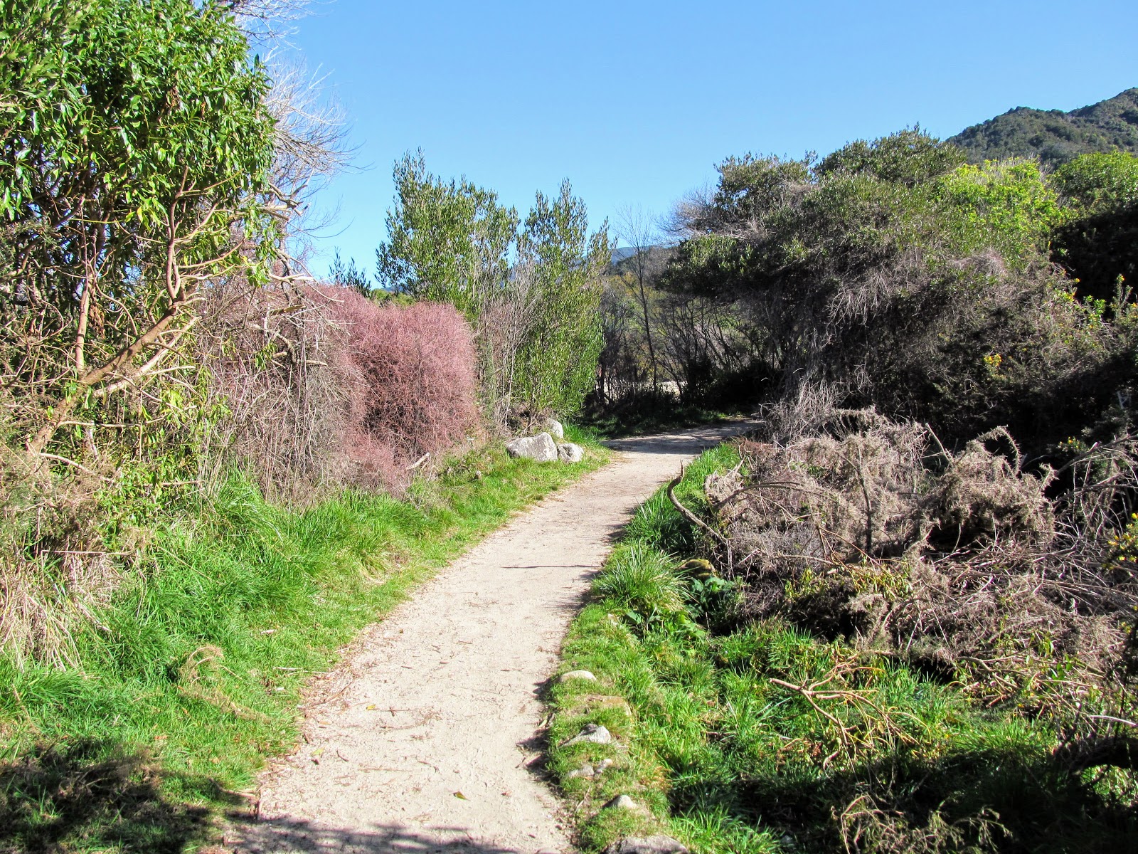
The first part of the day is back down the beach for about 500 meters to the Anchorage Access Track which starts right off the beach...
 |
| Heading along Anchorage Beach on the morning of day three... |
 |
| Last view of the southern end of Anchorage Beech...day three... |
 |
| The low saddle from Anchorage to Torrent Bay, Abel Tasman Coastal Track |
The last day of this trip consists of the climb from Anchorage up to the main Abel Tasman Coast Track which takes you from sea level to 200 meters asl. After this it is a gently sidle along the coast for about 3 hours to Marahau. The track gradually descends down to the coast just past Tinline Campsite and then follows the Marahau Estuary around to a set of causeways at the tracks end.
 |
| Map: Abel Tasman NP: Anchorage to Marahau |
There was a lovely golden light over the lake and hills at the back of Anchorage Beach. A magnificent view when you are just starting out on a long days travel...and a good omen of a fair weather day ahead.
 |
| Heading inland to reconnect with the Abel Tasman Coastal Track |
 |
| Goodbye Anchorage...see you again soon... |
 |
| The sun lights up the hills above Anchorage, Abel Tasman NP |
 |
| Tidal lake behind Anchorage Beach, Abel Tasman Coastal Track |
Walking up the Anchorage Access Track to the main track is not easy so I will not minimise the effort required to do so. It is about 2.5 kilometer's all up and the first kilometer is steep but after that it does level out quite a bit.
 |
| Anchorage Access Track: climbing back up to the main track |
 |
| Climbing into the sunlight on the Anchorage Access Track |
The views of the surrounding area get better and better as you climb and this was enhanced by the sun rising up over the surrounding hills. Eventually you can see over the hills to Torrent Bay and the tidal crossing across the estuary there...
 |
| View from the Anchorage Access Track of Pt.100, Anchorage, Torrent Bay |
 |
| View back down the Anchorage Access Track to Anchorage |
When you get up to the lookout near Pt. 87 on the Anchorage Access Track you can see over the ridge to Watering Cove, Adele Island and the Astrolabe Roadstead. There were 4-5 yachts moored off the western side of the island...this is the most protected anchorage around the island.
Abel Tasman, D'Urville and Captain Cook all moored in this area during their voyages of discovery as it was such a ideal location. There were abundant fish stocks, fresh water and birds in the surrounding bush as well as large trees suitable for masts and cross arms.
 |
| Adele Island from the Anchorage Access Track |
 |
| View north from the Anchorage Access Track to North Head and beyond |
 |
| My silhouette on the ridges along the Anchorage Access Track |
 |
| Mt Evans and Inland mountains from the Anchorage Access Track |
 |
| Goodbye Torrent Bay...see you again... |
Past Pt. 87 the track levels out as it heads along the top of a ridge-line inland to the Abel Tasman Coast Track. You could see both the Bryant and Richmond Ranges to the south and the whole coastline both north and south of Anchorage.
 |
| Adele Island, Fisherman Island and the distant Richmond Range from Anchorage Access Track |
 |
| Adele Island, Richmond and Bryant Ranges from Anchorage Access Track |
The forest changes to tall Manuka/Kanuka as you get close to the junction with the main track. I passed the DOC Ranger along here...we exchanged a few words. He was on his way to Anchorage to start his five day stint along the track.
He was a different chap from the one who used to work up here...about my age and quite fit looking. The Abel Tasman must be one of the choicest postings within DOC..I bet there is a lot of competition for it.
 |
| Anchorage Access Track: clay track heading to the main route |
 |
| Junction of Anchorage Access Track and Abel Tasman Coastal Track |
I got to the track junction with the
Abel Tasman Coast Track after 40 minutes...I stopped for a drink and then set off along the track in the direction of Marahau....
 |
| Onto the Abel Tasman Coastal Track from Anchorage |
 |
| Awesome flat track heading to Marahau...Abel Tasman NP |
DOC are undertaking a Wilding Pine eradication program up here...seeds get blown into the park from the exotic forests which surround it and start to overwhelm the native trees. It would be hard work managing it as this area is all hills, gully's and rough terrain.
 |
| There is a wilding pine control program underway in Abel Tasman NP |
There is a side track about 10 minutes down the main track which leads to Holyoake's Clearing and the Inland Track. It takes about 2 hours to get to the clearing where someone once tried to make a living by farming to little success. There is a small 2 person bivy there after which it is another 2.5 hours to Castle Rocks Hut in the interior of the park.
 |
| Junction of Abel Tasman Coastal Track and Inland Track |
 |
| The Inland Track is less manicured than the Coast Track... |
One of the main features of this last day of the Abel Tasman Coast Track is all of the bridges you cross. I knew there were a lot of them but I actually counted them on this trip and was surprised to see there are 50 bridges from Anchorage to Marahau.
It is actually 51 if you count the now defunct bridge at Anchorage Beach....the river behind the beach has eaten away the land around the bridge so it is sitting in the middle of a sand hill about 5 feet off the ground and quite useless. So goes the follies of man...
 |
| The Anchorage Beach bridge to nowhere...Anchorage, Abel Tasman NP |
That is a lot of bridges...keep an eye out for them over this post...
 |
| Abel Tasman Coastal Track: bridge 1 of 50 on day three... |
They terrain along this section of the track consists of either open Manuka/Kanuka forest (usually on the headlands) and dense semi tropical bush in the gullies in between. There was a marked temperature difference when entering the gully's...they would have been a good 5-10 degrees colder than the open forest. This was usually due to the waterways running down the gully's to the sea...it moderates the local climate.
 |
| Dense semi tropical forest along the Abel Tasman Coastal Track |
 |
| Sun dappled headland on the Abel Tasman Coastal Track |
The track construction is interesting along the Abel Tasman Coast Track, there is a defined benching to the track with the inland walls cut from the clay soil that underlies the forest. The surface gradually gathers a layer of moss and small ferns till it resembles the photo below. It looks like it has been there for a long time but it is probably less than 20 years old...
 |
| The cutting surface along the Abel Tasman Coastal Track |
 |
| Nicely benched track...Abel Tasman Coastal Track |
I got to the turn off to Observation Beach at around 9.20 am...this is roughly a 1/3 of the way to Marahau. It would take you about 20 minutes to walk down to Observation Beach if you were camping there for the night and the same to climb back up the next day.
 |
| Abel Tasman Coastal Track: track sign at the turn off for Observation Beach |
 |
| Jon on the Abel Tasman Coastal Track |
 |
| Rimu grove near Cyathea Cove, Abel Tasman Coastal Track |
One of the other features of this day are the excellent views of the bays, beaches and offshore islands along this part of the coast. Every now and then a window will open in the forest canopy and give you a view of some attractive aspect...
 |
| Looking down on Adele Island from the Abel Tasman Coastal Track |
I counted the bridges along the coast in tens...here is number 10 of 50....
 |
| Abel Tasman Coastal Track: bridge 10 of 50 on day three... |
 |
| Most of these side creeks are dry on the Abel Tasman Coastal Track |
 |
| Abel Tasman Coastal Track: Yellow Point comes into view... |
I stopped at the Yellow Point track junction and headed down the track to the view point at the end of this peninsula. The track is about 250 meters long and takes you to a lookout with limited views up and down the coast. Im not sure it is really worth the effort but I had decided to take some of these side tracks to see what I was missing.
 |
| At the Abel Tasman Coastal Track-Yellow Point Track Junction |
 |
| Heading down the Yellow Point Track |
 |
| On the Yellow Point Track to the lookout |
There is a particularly good view of the Adele Island roadstead from near the end of the Yellow Point Track. There were 4-5 boats moored there..all of them were sailing vessels of one type or another. You can also see down to
Akersten Bay campsite which is often used by sea kayakers heading along the coast.
 |
| Adele Island and Astrolabe Roadstead from the Yellow Point Track |
 |
| Looking down to Akersten Bay from the Yellow Point Track |
After five minutes I headed back up the track to the junction with the main track and had a 10 minute break. There are a couple of semi dry spots you can sit at and enjoy a drink or snack. There must be a colony of Tui in the area as I could hear them calling out to each other....
There is also a side track from here down to Akersten Beach.
 |
| On the Yellow Point Track heading back to the main track |
 |
| My Atmos 50 pack at the Yellow Point Track junction |
 |
| Back on the Abel Tasman Coastal Track past Yellow Point |
Just past Yellow Point is Stillwell Bay...this is one of the few places along the coast that still has a private residence on it. There is a house and jetty here and a private track leads down to both from the route of the main track. Stillwell Bay is one of the few beaches without a campsite along this whole coastline.
This is one of those exceptions to the rule about no private land ownership within a national park...it was freehold land before the park was set up in the 1940's. If it ever goes up for sale it will probably be worth a couple of million dollars.
 |
| You can just make out Apple Tree Bay, Abel Tasman Coastal Track |
There are a multitude of pest traps set up in the park...mostly DOC 200's to combat possums, stouts and rats but also a lot of those new gas operated multi use traps. Project Janzoon and DOC do most of the trapping but there are others who also run trap lines.
All in a bid to increase the bird life within the forests.
 |
| There are multitudes of pest traps along the Abel Tasman Coastal Track |
There is a long attractive looking ribbon beach at Stillwell Bay which can be used by the public and is often visited by the sea kayakers. Stay away from the holiday home though please as it is a private residence.
 |
| Fisherman Island and Astrolabe Roadstead, Abel Tasman Coastal Track |
 |
| Stillwell Bay ribbon beach from the Abel Tasman Coastal Track |
 |
| Another angle on Stillwell Bay from the Abel Tasman Coastal Track |
Most of the bridges along the track are crossing creeks and streams but some of them are just there to bridge gullies blocking the route. Often the track is just wide enough for one person with a steep hill to your right and a drop off to the sea on your left.
 |
| Abel Tasman Coastal Track: bridge 20 of 50 on day three |
Lesson Creek is one of the larger waterways along this part of the Abel Tasman Coast Track. Not much water running the day I passed it but I have been along here after a night of rain and a torrent of water was passing beneath the bridge.
 |
| Lesson Creek from the bridge, Abel Tasman Coastal Track |
 |
| Standing on Lesson Creek bridge, Abel Tasman Coastal Track |
 |
| There is a waterfall just past the Lesson Creek bridge |
Adele Island and the Astrolabe Roadstead dominate the views between Yellow Point and Coquille Bay. The island is about a kilometer off shore and the space between it and the coast provides an excellent anchorage for ships. It was well used by the early explorers...Abel Tasman, d'Urville and Cook all spent time here.
 |
| Adele Island and Astrolabe Roadstead from above Stillwell Bay |
There are a lot of bluffs along this section of the coast so rerouting the track around them would be problematic. The track builders have carved into the rock of the hills to provide space for the track.
 |
| Abel Tasman Coastal Track: Manuka forest marks the areas of past forestry/farming... |
The presence of water means gully's are densely packed with bush...large podocarp trees like Totara, Rata and Rimu, tree ferns, small trees, flax and grasses. They are small oasis among generally dry open Manuka/Kanuka forest...
 |
| Abel Tasman Coastal Track: bridge 25 of 50... |
 |
| The side-stream above Stillwell Bay, Abel Tasman Coastal Track |
 |
| Large Totora Tree near Stillwell Bay, Abel Tasman Coastal Track |
The narrowest part of the track is between Stillwell Bay and Appletree Bay with fences at strategic points to stop you falling off the big bluffs which fall to the ocean.
 |
| Excellent view of Fisherman Island from the Abel Tasman Coastal Track |
 |
| There is a big bluff on the left of the fence...Abel Tasman Coastal Track |
There is an area of open forest just before you turn into Appletree Bay...this type of forest is dominated by one type of tree. It is bereft of under-story as the leaves from the trees are probably mildly alkaloid and they inhibit the growth of other plants under them. I have seen scattered patches of this type of forest right along the coast of the park.
I am still trying to identify this type of tree...I think it might be Mahoe or Whau both of which grow in the park. Please drop me a line and let me know what species it is if you are a botanist of good repute.
 |
| Abel Tasman Coastal Track: Open forest on the way to Appletree Bay |
 |
| A large Totora growing on a rock near Appletree Bay |
I have always wanted to camp at Appletree Bay campsite...it looks very nice with the small lagoon on the land side and the open ocean on the other. At some time long in the past someone planted some exotic trees here including some Norfolk Pines.
There is a toilet, picnic tables and tap water from a nearby stream...boil before use!!!
 |
| Abel Tasman Coastal Track: first view of Appletree Bay campsite |
 |
| Side track to Appletree Bay from Abel Tasman Coastal Track |
 |
| A panoramic photo of Appletree Bay, Abel Tasman NP |
 |
| The pines at Appletree Bay campsite, Abel Tasman Coastal Track |
Simonet Creek is the waterway which provides drinking water for the Appletree Bay campsite. It is one of the larger creeks along the coast and has a set of cascades both above and below the bridge. These are quite picturesque during or after rain as they drain a large area inland from the coast and often fill with water when it is wet.
 |
| Crossing the bridges at Simonet Creek,Abel Tasman Coastal Track |
 |
| Looking down Simonet Creek from the Simonet Creek bridge |
You can just see some of the pine trees planted down on Appletree Bay in the photo below through one of the frequent windows in the thick bush. They would provide much needed protection from the sun on the otherwise wide open beach.
 |
| Appletree Bay Campsite is on the sandbar in front of Simonet Creek |
 |
| There is a new sandbar near Adele Island...only visible at low tide!!! |
 |
| Abel Tasman Coastal Track: bridge 30 of 50 on day three |
 |
| I liked the shape of this bush along the Abel Tasman Coastal Track |
As you round the rocky Guilbert Point you get your first views of the coastline around Sandy Bay and Marahau. You can also see down to the lovely looking Coquille Bay with its golden sandy beach...
 |
| Abel Tasman Coastal Track: rounding Guilbert Point on the way to Marahau |
 |
| First view of Coquille Beach from the Abel Tasman Coastal Track |
 |
| Tokongawha Point and a distant Kaiteriteri from the Abel Tasman Coastal Track |
Between Appletree Bay and Coquille Beach I saw a coupe of areas where the ground just off the track had been churned over as if a plough had passed through. This is the work of feral pigs...they root around in soft soil looking for roots and insects to eat. I have seen similar churned up areas in Nelson Lakes NP, Kahurangi NP, Mt Sumner FP and on the Queen Charlotte Track.
Come on hunters of Nelson...someone is missing out on some prime pork on the hoof here...
 |
| Abel Tasman Coastal Track: pigs have been turning over the ground... |
 |
| More pig sign along the Abel Tasman Coastal Track |
Here is bridge number 35 of 50 on my way along the Coast Track...this stream flows down to Coquille Bay at its northern end. Not a raging torrent but still running despite the dry conditions the area has experienced recently...
 |
| The creek feeding down to Coquille Bay...bridge number 35 of 50 |
 |
| The side creek feeding down to Coquille Bay, Abel Tasman Coastal Track |
Both the distant Bryant and Richmond Ranges are visible from the track for most of the last day. These are the two mountain ranges which separate the Nelson-Tasman area from Marlborough. You can basically see the mountains from Nelson Lakes to the outer Marlborough Sounds and d'Urville Island.
I have plans to walk some or all of the Richmond Range as part of my Te Araroa Trail sections for the 2020/2021 season. I have been up Dun Mountain near Nelson but I have never tramped the Northern Bryant Range as there are bugger all tracks through there.
 |
| The distant Bryant Range from the Abel Tasman Coastal Track |
Coquille Beach looks like a very nice place to spend a day...it is only an hour and a half from Marahau on the Abel Tasman Coast Track. There are Aquataxi boats to the beach in summer so check out their schedules. You could walk in for a day at the beach and then catch the boat back to Marahau..or vice versa.
Not every trip into the Abel Tasman has to be a massive multi-day mission...
 |
| Coquille Bay from the Abel Tasman Coastal Track |
 |
| On the Abel Tasman Coastal Track above Coquille Bay |
 |
| Last view of Fisherman Island and Guilbert Point |
Halfway between Coquille Beach and Tinline Campsite is the junction of the Abel Tasman Coast Track and the Inland Track. The
Inland Track is not like the easy walking along the coast...it is tiger country. Rugged terrain, overgrown tracks, big hill climbs, dense forest and older & more basic huts. Good Kiwi style tramping in other words.
I have been trying to get up here for years...maybe 2020/2021 will be the season. The closest I came was back in 2018 when
I walked to Awapoto Hut at the northern end of the track. Unfortunately I aggravated an old ankle injury by falling over a bloody tree root and had to bail out.
I'm going to get there...one day!!!
 |
| The Abel Tasman Coastal Track and Inland Track junction at Tinline Bay |
 |
| Abel Tasman Coastal Track: only 2.3 kms left to Marahau... |
 |
| First clear view of Marahau from the Abel Tasman Coastal Track |
The
Tinline campsite is 300 meters (10 minutes) down the Abel Tasman Coast Track from the Inland Track junction. It is a huge spacious area with plenty of tent spots for avid campers. The campsite has toilets, water on tap (boil before use), picnic tables and enough space for about 20+ tents.
The area is named after a tin mine that once operated in the upper reaches of Tinline Creek. It must have been one of the few places in New Zealand where there are tin deposits...it is not a common element here.
 |
| Arrival at the Tinline Campsite, Abel Tasman Coastal Track |
 |
| Plenty of space for tents at Tinline Campsite, Abel Tasman NP |
I stopped here for 20 minutes to have some lunch and to take a break after walking for nearly two hours. There are plenty of shady spots to sit, eat, contemplate life and the impending end to another great tramping trip.
There were a multitude of Fantails around the clearing...I saw more than a dozen here and as I looked up the surrounding hills I could see dozens more flitting about. I don't think I have seen so many in one place before...
There is a short nature walk at the top end of the camp site...it heads up the side of Tinline Creek and then loops back to the open camping flats.
 |
| Lunch at Tinline campsite: crackers, cheese and salami sticks |
 |
| It was hot so time for the sun hat....Abel Tasman Coastal Track |
 |
| The Abel Tasman Coastal Track heading to Anchorage |
From Tinline Campsite it is about 2 kilometer's to the end of the track at Marahau. Most of this is flat travel through coastal bush with the occasional short up and down to get past ridges which come right down to the coast.
You are on the last hour of your tramp once you cross Tinline Bridge and start walking along the coast...
 |
| At Tinline campsite heading back onto the Abel Tasman Coastal Track |
 |
| The bridge over Tinline Stream, Abel Tasman Coastal Track |
 |
| The flat track between Tinline campsite and Marahau... |
You get occasional glimpses of Marahau as you walk along the coast...it is on the far side of the tidal estuary that stretches across Sandy Bay. It was lovely and cool walking along in the shade of the trees which line both sides of the track...
 |
| Tinline Bay from the Abel Tasman Coastal Track |
 |
| Abel Tasman Coastal Track: some of the Tinline section is in thin forest |
 |
| Looking out to Tinline Bay Bryant Range from the Abel Tasman Coastal Track |
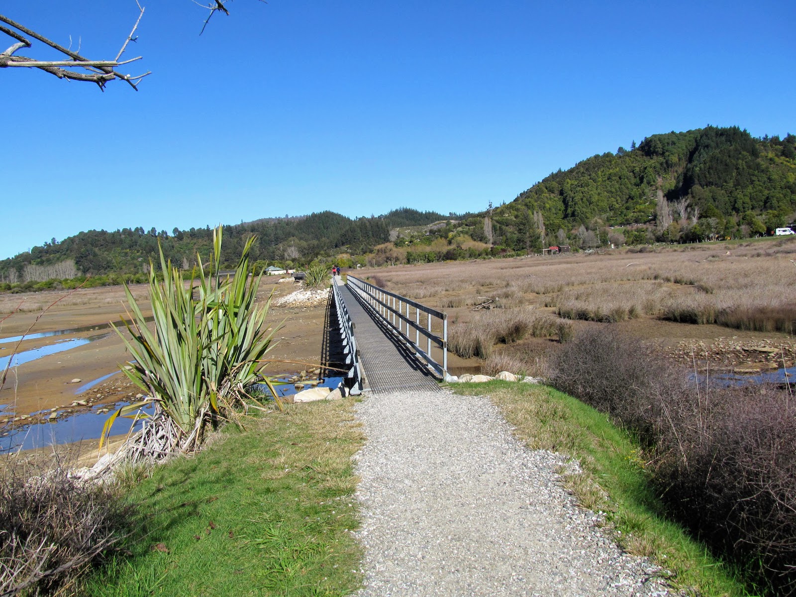
You get your first view of the end of the track about 20 minutes walking from the causeway across Sandy Bay. Before the causeway was built this was a tidal crossing which could only be crossed at low tide but this section of the track is now an all weather...all tide track.
 |
| The end of the Abel Tasman Coastal Track is in sight... |
 |
| Abel Tasman Coastal Track: bridge 45 of 50 on day three... |
There was a lot of young Kanuka planted along the sides of the track...they are only a couple of meters high but they will be monsters one day
 |
| Lowland coastal forest between Tinline and Marahau...Kanuka trees |
You know you are near the end of the Coast Track when you come to a section of well maintained gravel track five minutes from the causeway. There is a sign here which marks the edge of Abel Tasman National Park...everything on this side of the causeway is park land.
 |
| Better quality track as you approach the Marahau Estuary causeway... |
 |
| The official start/end of the Abel Tasman Coastal Track at Marahau |
I reached the end of the track just after 12 noon after walking for four hours from Anchorage. Once you walk past the official end to the Coast Track you just have the walk over the Marahau Causeway and along the road to your car.
 |
| The end of the Abel Tasman Coastal Track at Marahau |
 |
| Low tide at Marahau Estuary, Abel Tasman Coastal Track |
 |
| Fisherman Island as seen from the Marahau Causeway |
The causeway has five bridge sections and crosses the western end of the tidal estuary at Sandy Bay. You will be crossing bridges 46-50 on this section of the Coast Track...a fitting end given bridges are the main feature of this end of the walk.
I stopped along here and talked to an older couple from Richmond...she was pushing her husband along the track in a wheelchair.They were returning to visit the location of past adventures...they came to the park with their kids every year back in the 1970's & 1980's. We had a good chat about how the park was progressing and what new features had been added since their days.
That is the future for all of us I suppose eventually there will come a time when the legs just wont propel you along the tracks anymore.
Not yet though...not yet...
 |
| Abel Tasman Coastal Track: bridge no. 46 on day three... |
 |
| ...bridge 47 on the Abel Tasman Coastal Track.... |
 |
| ...bridge 48.... |
 |
| ...bridge 49... |
 |
| ...and finally bridge 50, on the last day of the Abel Tasman Coast Track.... |
I finally walked off the track just after 12.20...three days and 30 odd kilometers after setting out. They have built a new Maori gateway at the entrance to the track...I like it a lot. This area was a historic location for Maori settlement and food gathering so it is appropriate to mark this in some way.
 |
| The Maori gateway at Marahau, Abel Tasman Coastal Track |
The end to another excellent adventure in Abel Tasman National Park...I will be back soon as I have many other adventures to complete in the park. I would like to finish that Inland Track journey and I have long wanted to do a summer camping trip to the park.
 |
| Doc sign at the Marahau start of the Abel Tasman Coast Track |
I have also recently found out about an off piste route from Canaan Downs to the top of Mt Evans. Canaan Downs is also the best approach to Wainui Hut so you can see there is still plenty of tramping to do in the park.
Back in Marahau...end of the trail:
From the end of the track it is about 1 kilometre or 20 minutes walk back to the Aquataxi car-park at Marahau to collect the car. I stopped for five minutes to take some photos of the entrance to the national park and then set off down Marahau-Sandy Bay Road in the direction of the Aquataxi Center.
 |
| Looking back into Abel Tasman NP from Marahau |
 |
| Toilet block at the Marahau end of the Abel Tasman Great Walk |
DOC have re arranged the entrance to the national park with a new shelter at the end of the track, new toilets and some native planting and Maori inspired statutes to mark the location. It is a much nicer introduction to the park than the old covered shelter.
 |
| Looking up to Rata Hill and the Inland Track, Abel Tasman NP |
There is a cafe located at the entrance to the national park...not open over winter unfortunately!!!
 |
| The cafe at the end of the Abel Tasman Great Walk |
There is a walkway alongside the Marahau-Sandy Bay Road which will take you safely back into Marahau. Watch when you are crossing the bridge over the Marahau River as there is a blind corner on the Marahau side and cars come powering over the bridge leaving you little space on the roadway.
 |
| On Sandy Bay-Marahau Road heading to the car at Marahau |
I usually stay in Motueka when visiting Abel Tasman NP as it is a larger town with more facilities... bars, motels/hotels, restaurants, cafes, grocery shops etc. However, there are a number of different accommodation options in Marahau itself ranging from expensive Air BnB's right through to dormitory style rooms in backpacker hostels.
 |
| Kaiteriteri also had accommodation options close to Abel Tasman NP |
One of the nicer providers is
Abel Tasman Lodge which is the best middle of the range option this close to the park. It is not cheap but I read a magazine article about it last year and it looks very nice...go on...spoil yourself!!!
 |
| One of the accommodation providers at Marahau, Abel Tasman |
 |
| Abel Tasman Lodge at Marahau, Nelson-Tasman region |
FYI: there is a set of public toilets and a rubbish disposal station down by the Outdoor Education Centre opposite Makatu Holdings land at the Marahau shorefront. This is the only place to find public toilets in Marahau so make use before heading off. The next closest are in either Kaiteriteri or right back in Motueka.
 |
| Public toilets on Sandy Bay-Marahau Rd, Marahau |
I see that the old campground fronting Marahau Beach is still undeveloped...a joint Maori/Chinese group own the land and want to build a multi million dollar resort here but they cannot get planning permission from DOC, the regional council or central government. None of them think it has anything to offer the local community which I would tend to agree with.
You can use the beach as it is crown land but you aren't allowed up beyond the edge of the beach.
 |
| Warning sign at the old campgrounds at Marahau |
 |
| The lovely beach at the old campgrounds at Marahau |
 |
| Another view of the beach at Marahau from a visit in 2017 |
The tide was fully in so you can see the difference in water depth...the tidal range is 5+ meters in the Abel Tasman. At low tide you could walk nearly 700 meters across the sand flats to reach the edge of the ocean. It really is quite spectacular...
The yellow film on the water is pine tree pollen from the extensive exotic forests just inland from the coast. My car had so much on it that a big yellow cloud blew off the rear when I started driving away from Marahau.
 |
| View towards Tokongawha Point, Marahau |
 |
| Looking back to the Abel Tasman NP from the Marahau Seafront |
 |
| Outer Marlborough Sounds and d'Urville Island from Marahau |
I took some photos of the Aquataxi HQ on Franklin Road as I walked past on the way to the car-park. They had a boat sitting ready to go...probably the afternoon pick ups from further up the coast as they only have outgoing trips at 09.30 and 11.00.
 |
| The Marahau Center at Marahau...again from 2017 |
 |
| The Marahau Aquataxi collection point on Franklin Road |
BTW: Aquataxi run a shuttle service to Motueka, Kaiteriteri and Nelson...it is free to the first two destinations but costs $15 per person to get to Nelson. They run early in the morning and late in the afternoon to coincide with the taxi schedule. Check out their website for more information...
 |
| Aquataxi run a shuttle service to Motueka, Richmond and Nelson |
I finally made it back to the Silver Surfer at around 12.25 so it was roughly 4.5 hours walking from Anchorage to Marahau. Really it was 4 hours as I had a long lunch break at Tinline Campsite and I could really have just kept walking.
It was good to see the Surfer safe and sound at Marahau...this is a fairly secure parking spot but you can never be sure. I was pleased to sit down when I got to the car as it was starting to heat up. I had stashed a full 1.5 liter bottle of water in the car and it was still cold from the previous nights frost....lovely and refreshing.
 |
| The Silver Surfer at the Aquataxi parking lot at Marahau |
Python fans out there will know this awesome pose...
 |
| ...BASICALLY...I believe in...BASHING..two boots...TOGETHER...!!! |
So that was the end of my 6th (...or 7th...) trip into Abel Tasman National Park...I will be back in the future as I have planned a mission to walk the Inland Track set for October or November of this year. I haven't decided which end to start from as both have positive and negative points.
I had a good time although it would have been more fun if Karen was able to come with me (she could not get time off work). The weather was perfect for this time of the year and while it was moderately busy there were no huge crowds like you get over the summer.
Another excellent tramp in one of my favorite places in New Zealand....
Access: Water taxi from Kaiteriteri or Marahau, the trip takes one hour from Marahau, 1.5 from Kaiteriteri
Track Times: 13 kilometers or 4-4.5 hours Anchorage Hut to Marahau
Hut Details: Anchorage Hut: serviced, 34 bunks, wood burner, filtered water tank, wood shed, flush toilets; There are DOC camp sites at various points along the coast with spots for 5-70 tents, check the DOC website for details
Miscellaneous: Huts/campsites are on the DOC Great Walk booking system, must be booked for overnight visit. Hut warden in residence from 1st October to 30th April each year. Tidal crossing at Onetahuti Bay and Torrent Bay on this trip. There is a 2 hour, 5 km high tide track around Torrent Bay Estuary if the tide has come in.


No comments:
Post a Comment