Crossing from East to West at Lewis Pass....
The first track we finished on our recent camper van holiday to the West Coast was the short walk along the tarn at Lewis Pass. I have been here a couple of times in the past but Karen had never walked up to see the tarn and it is beautiful and in a stunning location. We decided to stop and have a look at the tarn even though we had only been driving for an hour at that point...
 |
| Lewis Pass Tarn from the eastern end..... |
 |
| Jon at Lewis Pass Tarn, Lewis Pass National Reserve |
Several tracks start from this locale and there are picnic tables, toilets and a trampers shelter located here which can be used by all visitors.
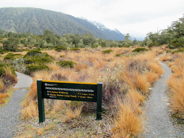 |
| Track Junction for St James Walkway and Lewis Pass Nature Track |
 |
| Our Britz camper van at Lewis Pass carpark |
It was the first of several walks and tracks we covered over the week and was a great starting point to the holiday.
A short stop at Lewis Pass Tarn:
There is a carpark at Lewis Pass just before you reach the highest point of the road where you can stop for a rest after climbing up from either Springs Junction or the Lewis River Valley. There is space here for around a dozen cars and especially on fine days and weekends it will be full of trampers and voyageurs enjoying the surrounding mountains.
 |
| First view of the Lewis Pass Tarn from the track... |
 |
| There is boardwalk to the eastern end of Lewis Pass Tarn |
From the carpark there are a couple of tracks you can access...on the southern side of SH 73 is the track to the Lewis Pass Tops and the series of lovely tarns along the top of the range of mountains to the east of the Maruia River. On the carpark side of the highway there are tracks to the Lewis Pass Tarn, Lewis Pass Alpine Loop Walk and of course the St James Walkway.
 |
| Moody setting at Lewis Pass Tarn with approach bad weather... |
 |
| Map: Lewis Pass and surrounds... |
I am going to stop here in mid October when I am enroute to a tramp in Abel Tasman NP and I am going to walk the Alpine Nature Loop Track. It skirts the tarn and then heads off to the left of the track and meanders through smaller tarns, swamp and gnarled Beech forest before heading back along the St James Walkway to the carpark.
 |
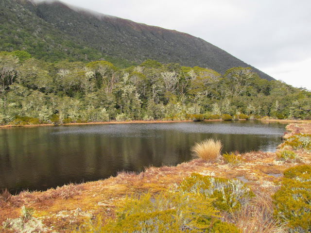
| The Lewis Pass Tarn is back by the Opera Range |
The tarn is moderately large and on a clear still day you will get reflections of the Opera Range on the surface. During colder weather I have seen the tarn completely frozen over though this only happens if there is a lot of snow laying on the ground at the pass.
 |
| Heading down the start of the St James Walkway |
 |
| Western end of Lewis Pass Tarn, Lewis Pass National Reserve |
Karen and I walked down the St James Walkway for about the first 500 meters of the track to where the track starts to descend down to the Maruia River and Cannibal Gorge. There is a suspension bridge there where the track crosses the Maruia and if you have the time and inclination the two hour return trip is an excellent day tramp.
 |
| Goblin forest as you start down towards Cannibal Gorge |
 |
| A DOC intentions kiosk at the start of the St James Walkway |
 |
| St James Walkway drops down to the Maruia River |
 |
| Cannibal Gorge suspension bridge in 2015 |
We had places to be so we didn't venture that far instead we turned around and started walking back to the camper parked near the tarn. It was super moody in the mountains as there was a rain front moving in so there were dark threatening clouds on the tops. It started to lightly rain as we got back to where we could see the van and this continued for the rest of the day.
 |
| Heading back towards Lewis Pass Tarn...Mt Technical to right |
 |
| The Libretto Range to the east of Lewis Pass Tarn |
Lewis Pass itself is another 400 meters up the highway and it is one of the four ways you can drive from east to west over the Southern Alps. The West Coast is wetter than the east so when you travel one of these roads you will see a change in the vegetation with Beech forest and tussock lands dominating the east and dense Podocarp forest to the west.
 |
| The carpark at Lewis Pass.....Lewis Pass National Reserve |
 |
| View back down the Lewis River Valley from the carpark |
It was a lovely way to start several days of walking and as always a great wee spot to take a break when driving across the Southern Alps. You have probably driven past the carpark numerous times over the years and never stopped but you should next time to take in the splendor of the surrounding country.
Access: From SH 7 (Lewis Pass Highway) a short boardwalk track leads to the Lewis Pass Tarn. You can access several other tracks from the carpark including the Lewis Tops Track, Alpine Nature Loop Track and the St James Walkway.
Track Times: It is two minutes to the Lewis Pass Tarn from the carpark (follow the signs). Other tracks are from 30 minutes to several days depending on length.
Miscellaneous: The Lewis Pass Tarn is in a high alpine area and as such is prone to extreme weather. There is a toilet and trampers shelter near the tarn available to all visitors. Severe avalanche risk on the Lewis Pass Tops & St James Walkway in Winter/Spring so only proceed if safe (check the Avalanche Advisory website).


No comments:
Post a Comment