At the famous Pancake Rocks in Punakaiki..
One of the main tourist highlights in Punakaiki are the famous Pancake Rocks on the coast at Dolomite Point. The Rocks look like..well a big stack of pancakes! They are ancient seabed which has been upthrust along the coast near here as the Australian Plate crashes into the Pacific Plate and forces up mountains and hills.
 |
| Dolomite Point and the Pancake Rocks from our accommodation... |
The Pancake Rocks normally receive over one million visitors a year with probably 3/4 of that number crammed into the period from November to April. That is a damn lot of people to have to deal with which is one of the reasons I have not been here for a long time.
I would rather be where the crowds are not!!!
I would rather be where the crowds are not!!!
 |
| Entrance to the Pancake Rocks Track at Punakaiki, West Coast |
With the exclusion of tourists from the country for probably the next year or two we have a golden opportunity to visit all those iconic spots that we Kiwis do not get to visit because they are over run with tourists. Mt Cook, Rotorua, Queenstown, Tongariro, Wanaka, the Southern Glaciers and the Great Walks are just some of the places we can go without huge crowds.
We should all make a concerted effort to visit these places both to support our local economy and to enrich ourselves mentally/spiritually/physically.
We should all make a concerted effort to visit these places both to support our local economy and to enrich ourselves mentally/spiritually/physically.
 |
| SH6 runs right past the entrance to the Pancake Rocks Track, Punakaiki |
Karen and I had a great weekend at Punakaiki...everything about the trip was good...great company, beautiful weather, nice accommodation, bugger all people about...what is not to like about that.
 |
| Sign on the entrance to Pancake Rocks Track, Punakaiki |
So here is a taste of what the Pancake Rocks has to offer you if you decide to visit...
The Pancake Rocks Track, Punakaiki
We arrived at Punakaiki around 3 pm after travelling over to the West Coast via Arthur's Pass & Greymouth. We decided to head down to the Pancake Rocks later in the afternoon...we were not certain what kind of weather we were going to get over the next couple of days so decided to jump in just in case it was miserable.
 |
| On the start of the Pancake Rocks Track |
The Pancake Rocks Track is located on Dolomite Point opposite the DOC centre on SH 6 about a kilometer south of Punakaiki settlement. It is clearly marked and obvious as it starts right from the highway and there is a ton of parking here. The track is hard seal along its length and easy to walk but be aware there are some stairs at the furthest point of the headland so it is not wheelchair friendly right along its path.
 |
| Some Nikau Palms along the Pancake Rocks Track |
We got to the track as dusk was coming on at around 4.30 p.m...because the sun is setting over the western horizon it was still relatively light. The setting sun cast a beautiful orange-gold light over everything but by the time we walked off the track about 40 minutes later it was really getting dark.
 |
| Nikau Palms are endemic along the coast at Punakaiki |
One of the features of the area are the Nikau Palm trees...yes they are an actual palm tree...only found on the upper West coast of the South Island, Golden Bay and places on Banks Peninsula. They really define the forests around Punakaiki as they are growing in profusion..there are whole groves of them at Truman's Track and up the Punakaiki & Pororairi Rivers.
 |
| DOC information panel along the Pancake Rocks Track |
There are actually some lights along this track so you could come down here in the dark if you wanted too. I would bring a torch as the parts of the track through the forest were really dark after the sun set.
 |
| View out to the Tasman Sea from along the Pancake Rocks Track |
 |
| One of the viewing areas on the Pancake Rocks Track |
 |
| Looking down into one of the coves, Pancake Rocks Track |
 |
| The Pancake Rocks are an ancient seabed.... |
The strip of coastal forest between the headland and SH 6 is really dense and full of the typical species of trees and bushes you would find near the coast. Im not sure if this is old growth or replanting...there are some really big Nikau Palms but everything else looks a immature.
The track around the reserve is sealed the whole way so it is plain easy walking when visiting the Pancake Rocks. They need a hard track surface as so many people visit the location, a gravel track would soon degrade. They have done a lot of work since I was last here in 1995..back then it was a bit rough and ready but tourist numbers have surged in the intervening years.
 |
| View back towards SH6 on the Pancake Rocks Track |
The sun was beautiful setting over the western horizon...it was worth the trip just to see this....
 |
| The sun sets over the Tasman Sea...Punakaiki |
 |
| The Pancake Rocks Track is sealed along its length... |
The Pancake Rocks are on the southern side of the reserve...they look out onto the Tasman Sea and south down the coast to the mouth of the Punakaiki River, southern Paparoa Range and all the way down the coast to the bottom of the South Island.
If you have a clear day you can clearly see Mt Aoraki/Cook, Mt Tasman and Mt Haast shining about +200 km's away. We managed to see them the next day when we visited in clear conditions.
 |
| View south along the coast from the Pancake Rocks Track |
 |
| Yeah....they look like a stack of pancakes..... |
 |
| Distant Paparoa Range visible from the Pancake Rocks |
This whole area is ancient seabed which has been forced up by the collision of the Pacific and Australian Plates. Because it is mostly limestone it has been easily eroded by sea, rain and wind action into the huge bluffs, coves, rock formations, caves and deep incised river valleys that charatorise the area now.
 |
| Dusk gathers over the ocean along the Pancake Rocks Track |
 |
| One of the link bridges on the Pancake Rocks Track |
The sea washes against and ultimately under-mines the coastal cliffs which collapse to form the coves and tidal surge pools on Dolomite Point. High pressure water also invades cracks in the rock and eventually erode large holes which become blowholes. As the waves crash into the bottom it forces jets of water spray out of them. The Chimney Pot is a good example of the blowholes you will see at the Pancake Rocks.
 |
| At the Chimney Pot at the Pancake Rocks, Punakaiki |
 |
| View down into the Tidal Surge Pool at Pancake Rocks |
When you get out to the end of the point there are some funky looking stairs which have been carved out of the multi layered rock. You can get a really good look at how this rock is layered...it is basically coarse sand compacted under the weight of the layers above it.
 |
| Pancake Rocks Track: a set of stairs carved from the limestone... |
I wouldn't want to fall into the Tidal Surge Pool...it looked like a agitated washing machine in there...sure to dead you in short order. The track is well fenced but I would still keep an eye on small children as there are places they can squeeze around fences.
Don't be like the utterly idiotic woman I saw posing for a selfie on an exposed rock with a huge drop on three sides. She climbed over a fence to get there past a sign that read "Extreme Danger. Do not cross this fence"
Don't be like the utterly idiotic woman I saw posing for a selfie on an exposed rock with a huge drop on three sides. She climbed over a fence to get there past a sign that read "Extreme Danger. Do not cross this fence"
All it would have taken was a slip, rock fall or a big gust of wind...but alas no...
" Mamma...you just killed that mam...
Stupid woman on a ledge...
Selfie picture...now she's dead...
Mamma...your'e a savage one...
Natural selection all the way....
Mamma ohhh ohhh ohh ohh...I really like your style
You know the way... to clean...the Gene pool..."
Mother nature decided to hold that strike-back...more is the pity!!!
 |
| Looking at the eastern side of the Surge Pool, Pancake Rocks |
 |
| Steps leading back up to the road, Pancake Rocks Track |
The sky setting out to the west is truly spectacular...if you have a clear afternoon when you visit you must come down and watch the sun setting. I love the marble like effect of the oranges mingling with the grey/purple clouds to produce all those color effects.
 |
| Wanning light at the Pancake rocks, Punakaiki |
 |
| Looking towards Punakaiki from the Pancake Rocks Track |
It was getting really dark as we walked off the track...the minimal lights along the route had come on but you really need a torch when walking through the forest section as it is very dark there.
Visiting the Pancake Rocks in daylight...
As I said at the top of this post we actually visited the Pancake Rocks Track twice while in Punakaiki, the first just on dusk and the other time in the middle of the afternoon. The contrast between the two times of the day makes multiple visits worthwhile....on dusk you have the sun setting over the Tasman Sea which gives the coastline a lovely golden-orange hue.
 |
| The Dolomite Point looks different in daylight... |
 |
| View back to the Coastal Range from the Pancake Rocks Track |
 |
| Pancake Rocks Track: view along one of the coves... |
 |
| You can just make out Mt Cook/Mt Tasman/Mt Haast from the Pancake Rocks |
Visiting during the day draws out the the deep blue color of the sea and its contrast with the verdant green of the forest which covers the coastal range of hills. You can certainly see the layering of the rocks much better...they are multi hued....tan, orange, grey, white and black.
 |
| Information panels at a Pancake Rocks Track viewpoint |
 |
| View south along the coast from the Pancake Rocks Track |
You could see much further up and down the coastline...the snow covered tops of the Mt Cook-Mt Tasman area stand out shining to the far south. You can also see many of the other high mountains of the Southern Alps down around Fox Glacier.
To the north you can see several headlands which jut out into the Tasman Sea including Cape Foulwind 50 odd kilometers to the north. This is a remote rugged coastline...transport must have been atrocious before the road was built. The Inland Packtrack was one way to avoid the coast...it loops from near Punakaiki inland and comes out near the Fox River 30 kilometers to the north.
 |
| Cape Foulwind is just visible to the north of Punakaiki, West Coast |
 |
| Rock spires off the coast of the Pancake Rocks, Punakaiki |
It was a much calmer day and while the ocean around here is never perfectly flat it was certainly noticeable. Punakaiki could be see shinning in the afternoon light off to the north of Dolomite Point...you could see the limestone cliffs, the village and the mouth of the Pororairi River clearly. There is a good information panel about 3/4 of the way around the track which explains how coastal uplift and river erosion has shaped this coastline.
 |
| Pancake Rocks: view towards Punakaiki and the mouth of the Pororairi River |
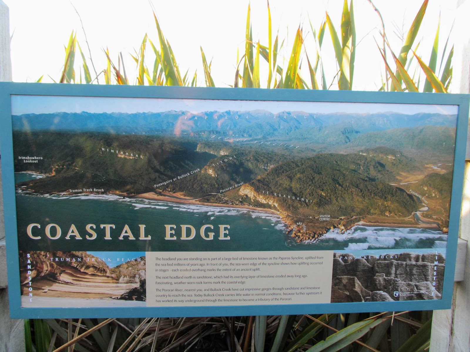 |
| Explanation of coastal uplift on the Pancake Rocks Track |
 |
| Recent rockfall at Dolomite Point, Punakaiki |
The forest at the back of the Pancake Rocks is super dense and a perfect example of lowland and coastal forest. While the track through it is not long it is wonderful to see all of the various types of trees and bushes you get on the Coast especially those funky Nikau Palms. DOC have done a magnificent job of providing access while still preserving a natural looking forest here...well done.
 |
| On the Pancake Rocks Track back to SH6..... |
The moon was up on the day we visited the Pancake Rocks, so....
"....By the dark of the moon, I planted
But there came an early snow
Been a hoot owl howling outside my window now
'Bout six nights in a row
She's coming for me I know
And on Wildfire were both gonna go...."
..is the song that always runs through my mind when I see the moon during the day.
But there came an early snow
Been a hoot owl howling outside my window now
'Bout six nights in a row
She's coming for me I know
And on Wildfire were both gonna go...."
..is the song that always runs through my mind when I see the moon during the day.
 |
| ...the moon rises over Punakaiki.... |
We all have a golden opportunity over the next two years to get out and enjoy our country without the distracting hub-bub of mass tourism. Personally, I am going to try to visit Lake Tekapo, Mt Cook, the Marlborough Sounds and Milford while it is quiet.
 |
| Covid-19 = less damn crowds at tourism hotspots!!! |
I would like to encourage all of you to go and visit some of those local spots you have always wanted to visit but have not. Don't go to Australia or the Islands...stay home and keep your tourism dollars local. Keep a Kiwi in a job.
If you have ever wanted to visit the West Coast and Punakaiki in particular...just do it...you will not regret a trip south.
If you have ever wanted to visit the West Coast and Punakaiki in particular...just do it...you will not regret a trip south.
Access: The start of the Pancake Rocks Track is directly opposite the Paparoa DOC office on SH 6 just before Punakaiki. It is well sign posted and obvious.
Track Times: From the start of the track it takes approximately 30-40 minutes (about 1 kilometer) to complete the circuit...the track can be walked in either direction.
Miscellaneous: There are several large car parks here as the site receives over 1 million visitors a year. DO NOT leave valuables in sight as this car-park is targeted by thieves. The track is sealed along its length but there is a section of steep stairs half way around. There are toilets, a cafe, gift shop and the local DOC office at the entrance to the track. 


